Florida, Georgia, Carolinas, and Northeast States Face Sharp January Pattern Flip With Mid-Month Warm Surge
FLORIDA — A significant atmospheric pattern shift is setting up across the eastern United States beginning mid-next week, bringing a noticeable warmup to several states that have spent much of late December under persistent cold. Forecast data shows this flip taking shape around January 8–9 and lasting through approximately January 11, temporarily disrupting the winter pattern across the Southeast and Northeast.
Weather models indicate that Florida stands to experience the most dramatic change, with temperatures potentially rising well above seasonal averages. After a colder-than-normal December, the state could see afternoon highs climbing into the 80–85 degree range for several days, signaling a brief return to spring-like conditions.
Why the Pattern Is Changing
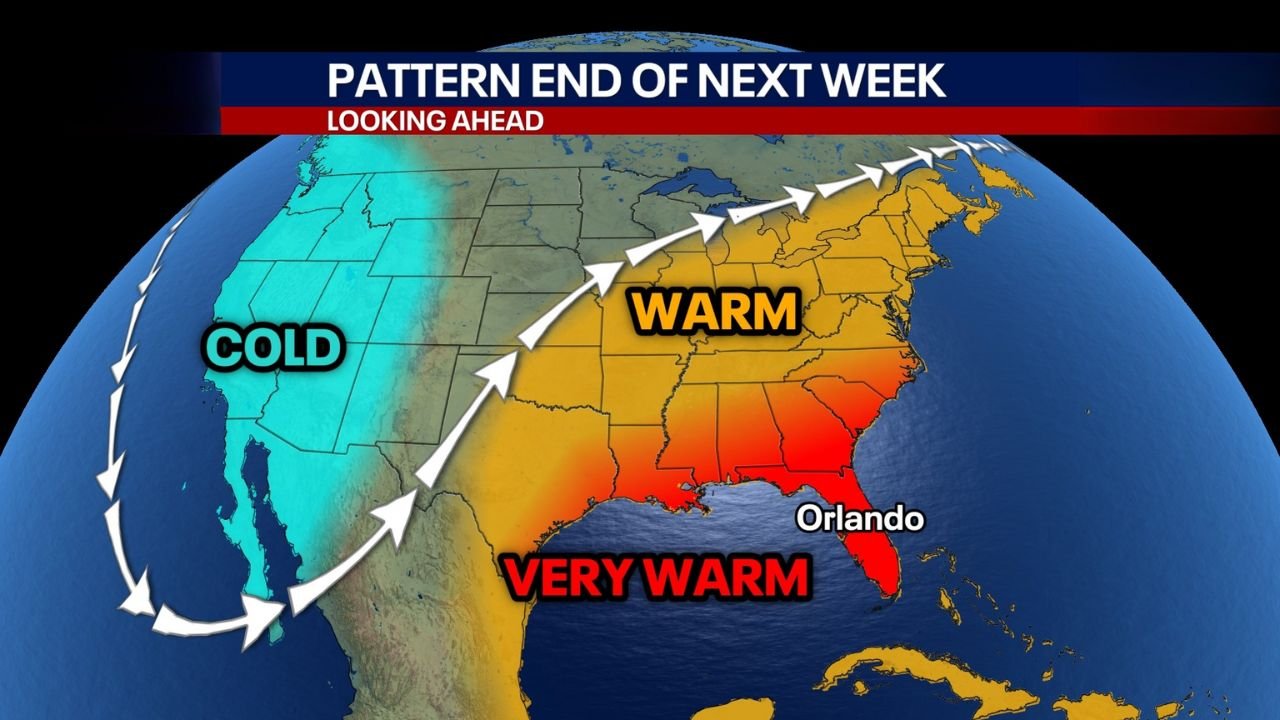
The shift is being driven by a large-scale realignment of the jet stream. Colder air that has dominated the eastern half of the country is forecast to retreat westward, allowing warmer air to surge north from the Gulf of Mexico and the southern Atlantic. This change places much of the Southeast and Mid-Atlantic on the warm side of the pattern while colder air remains locked across the western states.
Forecast graphics show a pronounced warm ridge expanding from Florida and Georgia northward through the Carolinas and into Northeast states, replacing the entrenched cold that has lingered since early winter.
Short-Term Winter Still Holding On
Despite the upcoming warmup, winter is not finished in the near term. In the days leading up to the pattern flip, Maryland and Pennsylvania remain in play for intermittent snow showers, with light accumulations possible overnight and during early morning hours. Forecast guidance continues to suggest mostly minor impacts, but flurries and brief coatings remain possible.
Light snow chances may also linger into Saturday night, depending on how quickly moisture and colder air interact before the warmer air mass takes over.
Warm Surge Will Be Temporary
Meteorologists stress that this warmer stretch does not signal an early end to winter. Longer-range outlooks suggest colder air could reload shortly after January 10–11, reintroducing more typical January conditions across the eastern U.S.
For now, the mid-January warm spell appears to be a pause in winter, not a full reversal — especially for northern states that have already seen sustained cold and snow.
What This Means Going Forward
Residents across Florida, Georgia, the Carolinas, and Northeast states should expect a noticeable temperature contrast over the next two weeks — colder conditions first, followed by a rapid warmup, then a likely return to winter later in January. Such pattern volatility is typical during mid-winter transition periods and often precedes more active weather later in the season.
Stay connected with ChicagoMusicGuide.com for continued weather updates, regional impacts, and detailed breakdowns as this evolving January pattern unfolds.