New York and Pennsylvania Buried by Historic Lake-Effect Snow as Lake Erie and Lake Ontario Produce Multi-Foot Totals
NEW YORK, PENNSYLVANIA – A relentless lake-effect snow event has delivered historic snowfall totals across parts of western and upstate New York and northwestern Pennsylvania, with some communities recording more than three feet of snow off Lake Erie and over five feet in the highest elevations east of Lake Ontario. The event stands out as one of the most intense lake-effect snow stretches of the season, driven by prolonged cold air flowing across unfrozen Great Lakes.
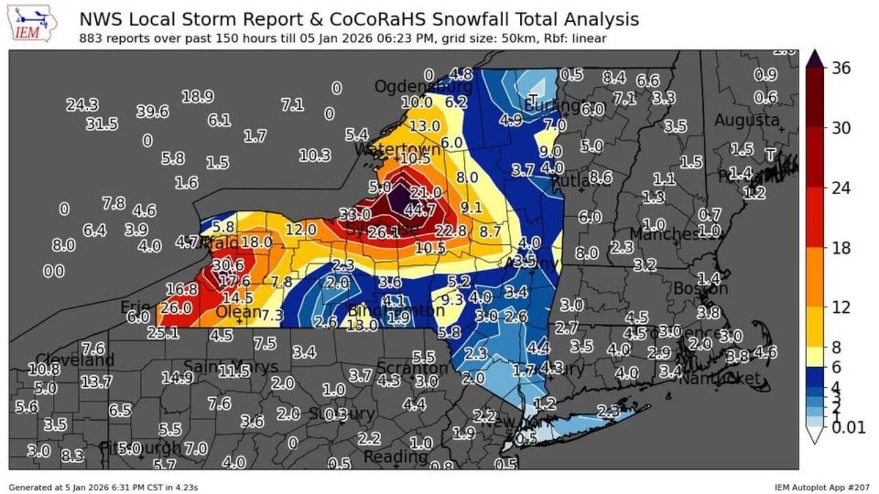
According to compiled National Weather Service Local Storm Reports and CoCoRaHS snowfall analysis, the heaviest impacts were tightly focused in classic lake-effect corridors, where persistent snow bands repeatedly moved over the same locations for several days.
Lake Erie Snow Bands Hammer Western New York and Northwestern Pennsylvania
The most extreme snowfall off Lake Erie targeted western New York, particularly the Boston Hills and Colden area south of Buffalo, where snowfall totals exceeded 40 inches, with some localized measurements approaching or surpassing three feet. These totals align with the darkest bands shown on the snowfall analysis map, indicating prolonged band placement rather than brief bursts.
Nearby communities across Erie County and southern Niagara County also picked up significant accumulations, while portions of northwestern Pennsylvania, including areas near Erie, saw notable but more variable totals as bands shifted south and weakened farther inland.
This sharp gradient highlights the highly localized nature of lake-effect snow, where a shift of just a few miles can mean the difference between manageable snowfall and near-paralyzing conditions.
Tug Hill Plateau Buried Under Extreme Snowfall From Lake Ontario
Even more dramatic totals were observed east of Lake Ontario, where the Tug Hill Plateau lived up to its reputation as one of the snowiest regions in the eastern United States. Snowfall analysis shows totals exceeding 60 inches, with several high-elevation locations approaching or surpassing five feet during this single lake-effect episode.
Communities downwind of Lake Ontario experienced continuous snowfall as cold northwest flow remained locked in place, allowing snow bands to regenerate repeatedly over the same terrain. The elevation of the Tug Hill region significantly enhanced snowfall rates, compounding already intense lake-effect processes.
In contrast, areas farther east into central and eastern New York saw sharply reduced totals as bands weakened and moisture was depleted.
Why This Event Was So Severe
This event’s severity can be traced to a long-duration cold air mass, minimal ice cover on the Great Lakes, and steady wind direction, all of which favored persistent lake-effect snow banding. Instead of brief squalls, the snow accumulated steadily over multiple days, allowing totals to climb to extreme levels.
Unlike synoptic winter storms that spread snow over wide areas, this lake-effect setup focused impacts into narrow corridors, leading to major travel disruptions, snow removal challenges, and dangerous conditions in the hardest-hit communities.
What This Means Going Forward
While lake-effect snow is common in this region, events of this magnitude highlight the importance of monitoring band placement, not just overall snowfall forecasts. Even modest shifts in wind direction can dramatically change which towns are impacted.
With cold air remaining present across the Great Lakes region, additional lake-effect snow remains possible later in the season, though totals will depend heavily on lake temperatures and ice coverage.
Have you experienced extreme lake-effect snow this season, or are you living in one of the hardest-hit areas? Share your photos, totals, and stories in the comments and stay connected with ChicagoMusicGuide.com for continued weather coverage and regional updates.