Great Lakes Ice Cover Rises Above Average as Lake Erie Nears 30% Freeze Across Ohio, Pennsylvania, and New York
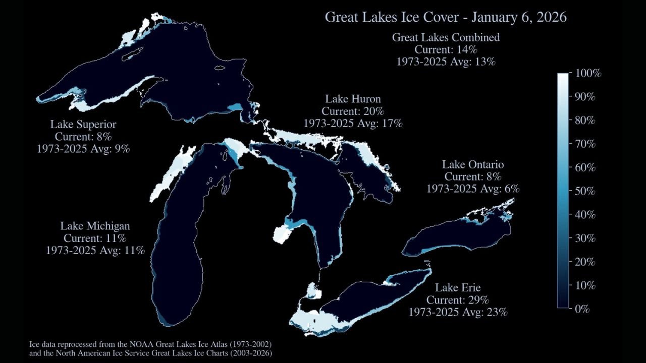
GREAT LAKES REGION — Ice coverage across the Great Lakes has increased steadily heading into early January, with new data from January 6, 2026 showing combined ice cover at 14%, slightly above the long-term seasonal average and signaling a colder-than-normal start to winter for parts of the Midwest and Great Lakes states.
The latest measurements highlight significant freezing on Lake Erie, while other lakes remain closer to seasonal norms as winter patterns continue to evolve across the region.
Ice Coverage Across the Great Lakes on January 6, 2026
According to the latest ice analysis, the five Great Lakes show uneven but notable ice development, driven by recent cold snaps and lake-effect conditions.
- Lake Erie: 29% ice cover (well above its long-term January average of 23%)
- Lake Huron: 20% ice cover (above its historical average of 17%)
- Lake Michigan: 11% ice cover (matching its long-term average)
- Lake Superior: 8% ice cover (slightly below its 9% average)
- Lake Ontario: 8% ice cover (above its 6% average)
When combined, the Great Lakes stand at 14% ice coverage, edging past the 1973–2025 average of 13% for this point in the winter season.
Why Lake Erie Is Freezing Faster Than the Others
Lake Erie’s sharp increase in ice coverage is not unusual but is especially important this early in January. As the shallowest of the Great Lakes, Erie cools and freezes more quickly during sustained cold weather.
This year’s pattern of repeated Arctic air intrusions, especially across Ohio, Pennsylvania, New York, and southern Ontario, has accelerated ice growth. Shoreline ice has expanded rapidly, and interior ice is beginning to consolidate—raising the potential for further rapid freezing if cold conditions persist.
What This Means for Midwest and Great Lakes Weather
Higher ice coverage can reduce lake-effect snowfall potential later in the season, particularly for areas downwind of Lake Erie and Lake Huron. However, during the transition phase—when lakes are only partially frozen—localized lake-effect snow bands can still intensify, especially during cold air outbreaks.
For states like Illinois, Indiana, Michigan, Ohio, Pennsylvania, and New York, this evolving ice pattern plays a major role in:
- Winter storm intensity
- Snowbelt snowfall totals
- Shoreline wind and wave conditions
- Long-term winter temperature moderation
How This Compares to Recent Winters
Compared to several recent winters marked by below-average ice coverage, early January 2026 is starting slightly colder and more seasonally consistent. While not extreme, the current numbers suggest winter is establishing itself more firmly than in many recent years, especially across the eastern Great Lakes.
If colder air continues to revisit the region through mid-to-late January, ice growth could accelerate quickly, particularly on Lake Erie and Lake Huron.
What to Watch Next
Meteorologists will be closely watching:
- The persistence of Arctic air masses
- Wind patterns that can break or consolidate ice
- Potential impacts on lake-effect snow later this month
A shift toward milder conditions could slow ice growth, while another strong cold wave could push overall Great Lakes ice coverage well above average before mid-winter.
If you enjoy detailed Midwest and Great Lakes weather breakdowns like this, stay connected with ChicagoMusicGuide.com and share your thoughts—how is winter shaping up where you live?