Mississippi, Alabama, and Georgia Face Elevated Tornado Threat as Nadocast Flags Concentrated Risk Zone
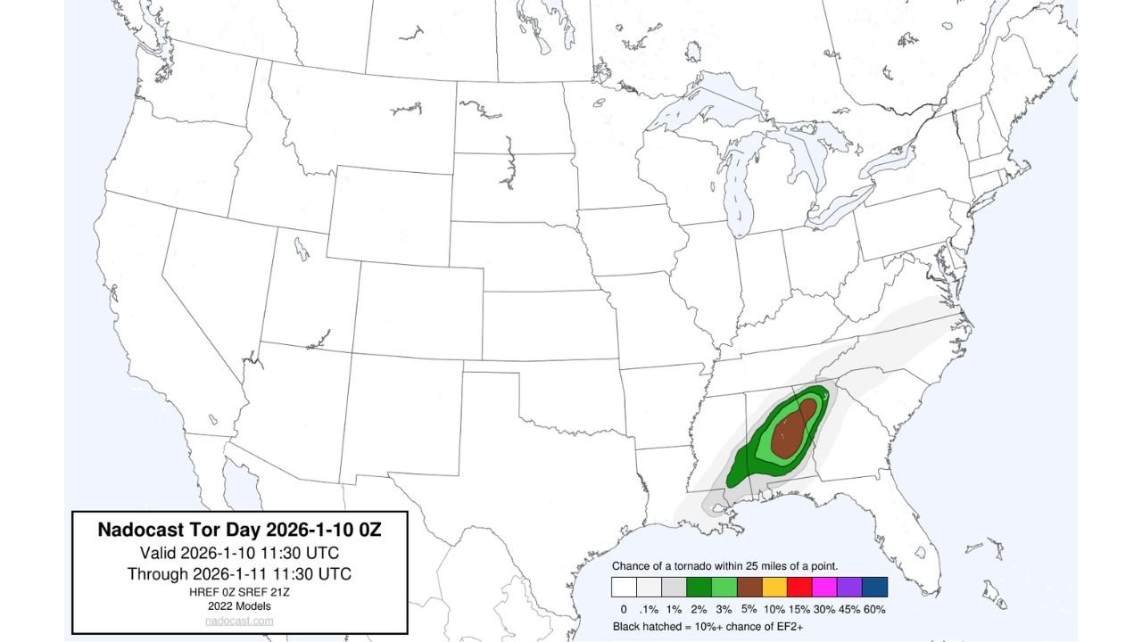
SOUTHEASTERN UNITED STATES — Updated Nadocast Day 1 tornado probability data valid from January 10 through early January 11 highlights a concentrated zone of elevated tornado potential across portions of the Deep South, signaling a weather setup that could support strong to potentially significant tornadoes if storms develop as projected. The forecast window spans from 11:30 UTC on January 10 to 11:30 UTC on January 11, capturing a critical overnight and early-morning period for severe weather development.
The shaded probability contours indicate a focused corridor where atmospheric conditions may align for rotating storms. While this is a model-based projection rather than an official warning, the signal is strong enough to warrant attention from residents, emergency planners, and anyone with travel or outdoor plans across the region.
Nadocast Probability Map Shows Focused Tornado Corridor
The Nadocast tornado probability maps, generated using updated 2022-era modeling, depict a pronounced risk area centered over parts of Mississippi, Alabama, and Georgia, with lower-end probabilities extending into surrounding states. The highest-shaded core represents locations where the chance of a tornado occurring within 25 miles of a point is notably elevated compared to surrounding areas.
Dark green to brown shading on the map corresponds to probabilities ranging from roughly 3% to 5%, which may appear modest at first glance but are meteorologically meaningful when tightly clustered. Historically, such concentrated signals often coincide with environments capable of producing supercell thunderstorms, particularly when instability, wind shear, and low-level moisture overlap.
The presence of black-hatched markings, indicating a 10% or greater chance of EF2+ tornadoes, underscores the potential for stronger tornadoes should storms fully organize. While these hatched areas are limited in spatial extent, they often serve as early indicators of where forecasters will be watching most closely.
Timing and Atmospheric Setup Raise Overnight Concerns
The valid period of the forecast emphasizes late evening through overnight hours, a time when tornadoes can be especially dangerous due to reduced visibility and lower public awareness. Nocturnal tornado events historically carry a higher risk of injury and damage, as warnings may be harder to receive and response times can be slower.
This setup typically suggests a strong low-level jet, increasing wind shear after sunset, combined with sufficient instability lingering into the night. When these ingredients align, storms can maintain rotation even without daytime heating.
Although exact storm coverage and intensity will depend on mesoscale details closer to the event, the modeled environment supports at least isolated tornado potential, with a non-zero risk of stronger, longer-track tornadoes in the most favored zones.
How Nadocast Differs From Traditional Outlooks
Unlike categorical outlooks, Nadocast focuses on point-based probabilities, offering a more granular look at where tornado risk may be maximized. It does not replace official forecasts but often provides early insight into evolving severe weather patterns.
The data shown incorporates HREF 0Z and SREF 21Z ensemble guidance, blending multiple model solutions to highlight consensus risk areas. This approach can sometimes identify localized corridors of concern before broader outlooks are updated.
It is important for readers to understand that probability does not equal certainty. A highlighted area does not guarantee tornadoes will occur everywhere within it, but it does indicate where conditions are most supportive if storms develop.
What Residents Across the Southeast Should Watch For
As this forecast window approaches, residents in the highlighted states should remain alert for official updates, especially any Severe Weather Outlooks, Watches, or Warnings issued closer to the event. Key signals to monitor include:
- Increasing mention of tornado potential in local forecasts
- Development of discrete thunderstorms ahead of a main line
- Strengthening winds overnight
- Watches issued during evening hours
Preparedness is especially critical overnight. Ensuring weather alerts are enabled, identifying a safe shelter location, and reviewing emergency plans can make a significant difference if storms intensify rapidly.
As the Southeast U.S. enters this potential severe weather window, the Nadocast data serves as an early reminder that winter-season tornado threats remain a reality. Weather conditions can evolve quickly, and staying informed is key. For continued coverage of developing weather patterns, regional impacts, and major forecast updates affecting communities across the country, visit ChicagoMusicGuide.com.