Pennsylvania, Ohio, and New York Face Late-Week Light Snow as Lake-Effect Bands Replace Earlier Storm Hype
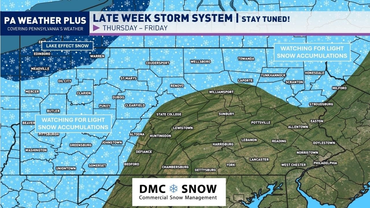
PENNSYLVANIA — A late-week winter system moving across the Great Lakes and Northeast is now expected to bring light snow and lake-effect activity across Pennsylvania, with additional impacts extending into Ohio and New York, according to updated forecast guidance. Earlier projections showing a more disruptive snowstorm have steadily weakened, shifting expectations toward minor, localized winter impacts rather than a widespread event.
Why the Storm Threat Has Been Scaled Back
Updated model data shows the upper-level system taking on a positively tilted structure, which limits its ability to consolidate moisture and produce heavy snowfall. Instead of a compact storm capable of widespread accumulation, the system is becoming elongated and weaker, spreading energy out over a larger area.
This evolution explains why snowfall projections that circulated several days ago have not held up. Forecast confidence has now increased that no major synoptic snowstorm will develop across the Mid-Atlantic or interior Northeast from this setup.
Lake-Effect Snow Takes Center Stage
Cold air pouring across Lake Erie and Lake Ontario will still be sufficient to generate lake-effect snow bands, particularly late Thursday into Friday. The highest short-term snowfall potential is focused on northwestern Pennsylvania, portions of northern Ohio, and western and central New York.
Lake-effect snow is notoriously uneven. Some locations may see quick bursts of accumulation, while nearby areas receive little or nothing at all. These narrow bands can briefly reduce visibility and create slick travel conditions despite otherwise quiet weather nearby.
Where Impacts Are Most Likely
Most communities across central and eastern Pennsylvania should expect light accumulations at most, with snow showers remaining intermittent. However, northwestern Pennsylvania, including areas closer to Lake Erie, remains the most likely region to see locally higher totals.
Forecasters are also monitoring the potential for snow squalls, especially Thursday afternoon and evening. These fast-moving bursts of snow can rapidly deteriorate road conditions and have historically contributed to multi-vehicle accidents across Pennsylvania during past winter events.
What Still Carries Some Uncertainty
While confidence is high that impacts will remain limited, exact placement of lake-effect bands remains uncertain. Small shifts in wind direction can significantly change where snow accumulates, even within short distances.
This uncertainty reinforces the need for short-range updates, especially for drivers and anyone traveling during the late-week period.
Why Early Snow Maps Missed the Mark
The early snowfall maps that gained traction online relied heavily on long-range single-model output, particularly runs that assumed ideal storm development. As newer data resolved the atmosphere more accurately, those high-impact scenarios faded.
This system serves as another reminder that snowfall projections shared five or more days in advance—especially without ensemble support—often overstate risk and fail to verify.
As winter weather patterns remain active across the region, staying informed with reliable, impact-focused forecasts is essential. For continued weather updates, travel-impact breakdowns, and forecasts that matter to live events and regional schedules, follow ongoing coverage at ChicagoMusicGuide.com.