Pennsylvania, New Jersey, and Delaware Brace for Rain-to-Snow Changeover and Lake-Effect Bursts Wednesday Night Into Thursday
HARRISBURG, PENNSYLVANIA — A midweek winter setup is lining up for parts of Pennsylvania, with rain expected to change over to accumulating snow Wednesday night into Thursday morning, followed by additional lake-effect snow and snow squalls that may linger into Thursday afternoon. While the heaviest impacts look focused on the western and northern portions of Pennsylvania, the broader region—including parts of New Jersey and Delaware—is being advised to stay winter-ready as colder air moves in behind the system.
The forecast messaging emphasizes a classic transition event: wet conditions first, then a colder push that flips precipitation to snow during the overnight and early-morning hours—often the worst timing for road conditions and early commutes.
Timing Breakdown: When Rain Changes to Snow and When Impacts Peak
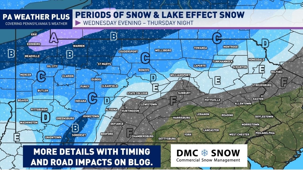
The timeline shown highlights Wednesday evening through Thursday night as the primary window for winter weather across the state. The most important period for accumulating snow is expected Wednesday night into Thursday morning, when colder air deepens and precipitation becomes more likely to stick—especially north and west of the central corridor.
The setup does not end when the initial changeover ends. The guidance also calls for additional lake-effect snow and snow squalls continuing into Thursday afternoon, which is significant because squalls can create rapid drops in visibility and sudden slick spots—even when snowfall totals are not extreme.
For drivers, this is the type of event that can look manageable early in the day and then deteriorate quickly as the changeover occurs, especially on untreated secondary roads and elevated surfaces like bridges and ramps.
Where The Highest Snow Potential Sits: Western and Northern Pennsylvania Zones
The mapped forecast divides Pennsylvania into impact zones across the state, with the strongest snow signal aimed at western and northern Pennsylvania. Areas closer to Lake Erie and the northwest corner—along with snowbelt-prone terrain—are highlighted for longer-duration snow potential, which aligns with the “periods of snow and lake-effect snow” headline.
Cities and regions that appear within or near the higher-impact shading include parts of:
- Northwest Pennsylvania near the Erie region
- The Laurel Highlands and higher elevations
- Portions of north-central Pennsylvania
- Northern tier communities where colder air arrives earlier
Meanwhile, the southern and southeastern portion of the state—including areas near Harrisburg, Lancaster, York, and toward Philadelphia—sits closer to a transition zone where precipitation type and accumulations may be more sensitive to small temperature changes. In these areas, the story may be more about timing, slushy bursts, and road temperature than deep totals.
Lake-Effect Snow and Snow Squalls: Why Thursday Could Stay Unpredictable
The added risk factor here is not just steady snow—it’s the mention of lake-effect and snow squalls persisting into Thursday afternoon. Lake-effect setups can keep snow going after the main system exits, and squalls can be particularly disruptive because they can create near-whiteout bursts for a short period.
Even a quick squall line can cause:
- Sudden slick road conditions
- Chain-reaction accidents on highways
- Visibility collapses during peak travel hours
- Rapid icing when temperatures fall below freezing
This matters for commuters and anyone traveling between cities like Pittsburgh, State College, Altoona, and into the northern tier. It also matters for anyone planning evening travel Thursday, since lingering snow showers can continue to create spotty hazardous conditions even after daytime impacts.
What This Means for Travel, Deliveries, and Midweek Plans Across the Region
Because this is a changeover event, the biggest real-world issue tends to be timing. Rain that falls ahead of the cold push can leave surfaces wet—then temperatures drop and snow begins accumulating, turning roads slushy and slick quickly. Western and northern Pennsylvania should be prepared for the strongest snow impacts, but even areas outside the bullseye can see brief periods of trouble when the changeover hits.
For New Jersey and Delaware, the broader takeaway is that colder air arriving behind the system can still create scattered travel hazards—especially if snow showers or fast bursts clip northwestern parts of the region or if temperatures drop quickly after rain.
For music fans and eventgoers, the key is planning around the worst travel window: Wednesday night into Thursday morning for the changeover, then Thursday afternoon for possible squalls. This is the kind of forecast where giving yourself extra time, checking local road conditions, and planning alternate routes can prevent a normal night out from turning into a stressful drive.
For more weather-driven planning updates tied to travel and event schedules, visit ChicagoMusicGuide.com for ongoing coverage of major winter impacts across key regions.