Texas, Florida, New Jersey, and Maine in the Snow Watch as Southeast Winter Storm Signal Strengthens for This Weekend
UNITED STATES – A developing winter-weather signal is putting a long stretch of the country on alert this weekend, with early guidance suggesting snow could be possible from far eastern Texas all the way to Maine if moisture and track details come together the right way.
What the latest setup is showing right now
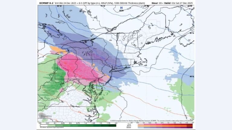
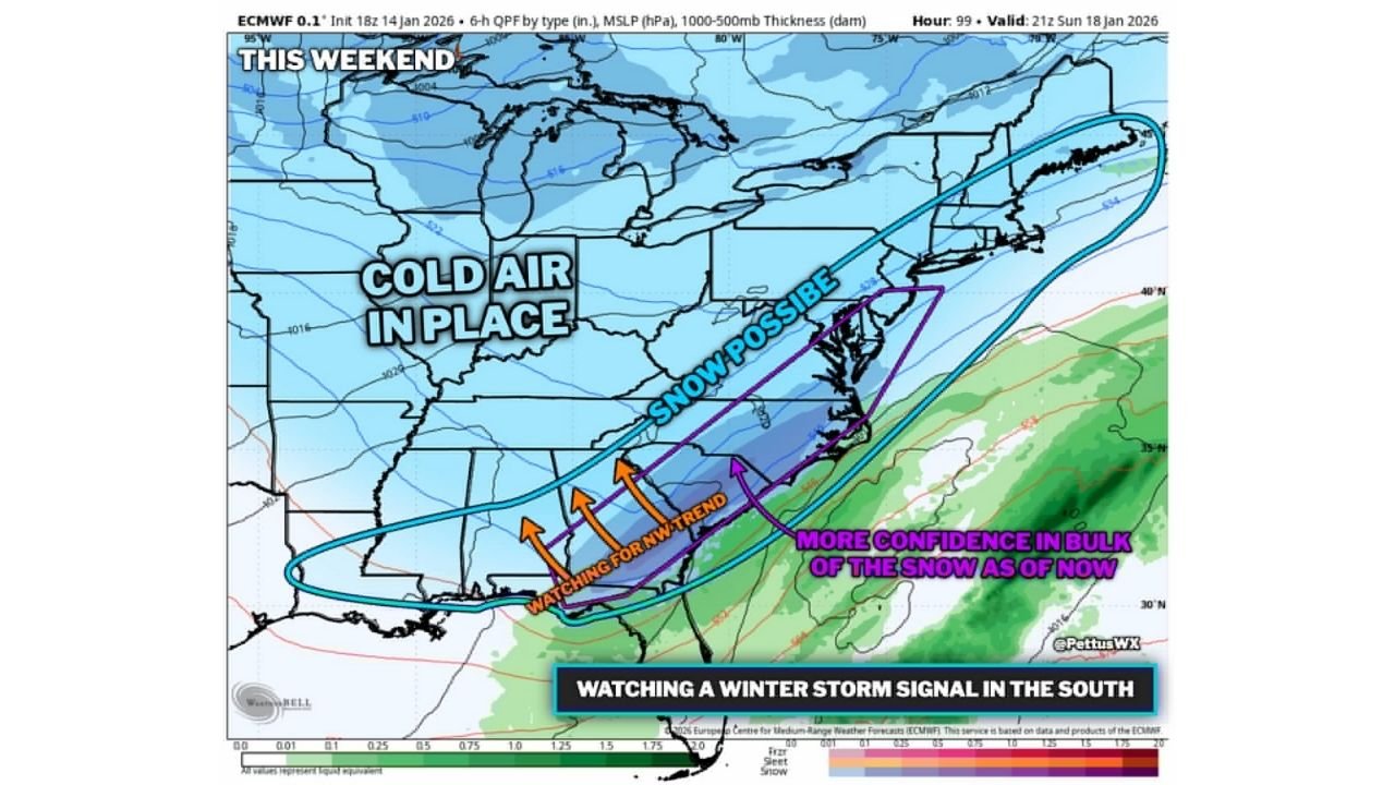
Cold air is expected to already be in place across much of the eastern half of the U.S., which is a key ingredient if a storm system is able to tap Gulf and Atlantic moisture. Current model guidance highlights a broad “snow possible” zone, but the most meaningful early confidence for higher snowfall is being focused on a corridor stretching from the Florida Panhandle into central New Jersey.
That doesn’t mean everyone in the larger zone sees snow — it means the storm track and moisture placement will decide who gets the steadiest precipitation while temperatures are cold enough for snow.
Where the highest confidence is at the moment
Based on the map and notes provided, the area being watched most closely for a more organized, higher-impact band is:
- Florida Panhandle (including the I-10 region) into portions of southern Georgia
- Across parts of the Southeast and into the Mid-Atlantic
- Toward central New Jersey, where the “bulk of the snow” confidence is being flagged right now
The “snow possible” area is broader and reaches much farther, which is why Texas and Maine remain part of the conversation at this stage. In this kind of setup, small shifts north or south can change the outcome quickly, especially along the southern edge where rain vs. snow lines can wobble.
Why forecasters are watching a “northwest trend”
The guidance notes specifically mention watching for a NW trend — that’s a common situation where the storm track gradually shifts farther northwest in newer model runs. If that happens, the snow axis can shift inland, potentially changing which cities see heavier totals versus lighter snow or a colder rain.
Right now, the message is clear: expect changes as newer runs come in, and avoid locking into one exact snowfall map too early.
What could happen if the storm organizes the way guidance suggests
If moisture sets up efficiently while cold air holds, impacts could include:
- Slushy to snow-covered roads in parts of the Florida Panhandle and inland Southeast where snow is uncommon
- Travel slowdowns on major corridors (including stretches of I-10 and routes feeding northeast)
- Localized heavier bands that can surprise drivers with sudden drops in visibility
- On-and-off changes in forecast totals until the track becomes more settled
Even if totals end up modest in some spots, the biggest issue for many southern locations is often road treatment and driver readiness, not just snowfall amount.
What it means for concert plans and weekend travel
For music fans, this is the kind of forecast that can impact drive times, parking lots, venue staffing, and load-in schedules — even when the event itself still happens. If you’re traveling for a show this weekend (or moving gear), a few smart steps can prevent a bad night:
- Plan earlier arrivals and assume slower highways if snow develops
- Keep an eye on local advisories the morning of your event day
- Bring warm layers even if your home area feels mild — cold air is part of this setup
- If you’re driving long-distance, pack a basic car kit (blanket, charger, water)
What to watch over the next few days
This is still in the “pattern watch” stage — meaning confidence is improving, but exact placement is not final. The clearest signs that a higher-impact event is becoming more likely would be:
- Multiple model runs keeping the same general track
- The “best snow corridor” staying consistent from run to run
- Stronger agreement on where the moisture sets up while cold air holds
If that corridor continues to point toward the Florida Panhandle through central New Jersey, expect growing attention from local forecasts in those areas as the weekend gets closer.
Are you traveling for a show this weekend — or already prepping for a possible snow day where you live? Share what you’re seeing in your area, and keep checking back with ChicagoMusicGuide.com for weather updates that help you plan your next night out.