Indiana, Illinois, Michigan, Missouri, North Carolina Snow Signals Rise as Late-January Pattern Turns Colder and More Active
INDIANA — A quieter-than-usual start to winter is starting to look less stable, with multiple forecast signals pointing to a more active late-January into early-February pattern across parts of the Midwest, Great Lakes, and the eastern U.S. Some areas are already dealing with short-term snow bursts, while longer-range guidance is hinting at bigger “storm track” potential as colder air repeatedly presses into the East.
Heavy snow risk increases late January across the Great Lakes and Midwest
A longer-range heavy snow outlook for January 21–27, 2026 shows a growing risk window across parts of the Great Lakes and surrounding states, with “slight risk” probabilities highlighted over the region. This type of outlook doesn’t guarantee a single blockbuster storm, but it does signal that the atmosphere may be lining up for one or more systems capable of producing impactful snow, especially as colder air is available and storm tracks become more favorable.
The key message in this outlook is timing: late January is when the pattern may finally “flip” from scattered minor events to more organized winter storms.
Indiana gets hit first: snow showers tonight with slick travel north of Indianapolis
Closer to the ground right now, Indiana is dealing with immediate winter travel issues. One forecast briefing indicates snow showers concentrating across far north-central counties, where 1–3 inches may fall before tapering off overnight. Outside that corridor, scattered flurries could still create a dusting up to around an inch, and the bigger concern becomes how roads react after sunset.
Drivers should watch for:
- Slick spots on untreated roads, especially as snowfall rates briefly increase
- Possible ice under a thin coating of snow, making traction worse than totals suggest
- Brief visibility drops north of Indianapolis, especially during heavier bursts
Even modest snowfall can cause outsized impacts when it arrives fast and temperatures hover near the freezing mark.
Lake-effect snow machine fires up near La Porte County, Indiana
Farther north, the threat becomes much more intense. A lake-effect-focused forecast highlights La Porte County, Indiana as a potential hot spot, with a “likely” snowfall outcome around 17 inches over roughly 30 hours, and higher-end outcomes pushing toward two feet or more in the most extreme scenario.
That’s the nature of lake effect: totals can vary sharply over short distances, but if bands lock in, communities can go from “manageable” to “overwhelmed” quickly.
If you’re in or near the lake-effect corridor (northwest Indiana into nearby areas), the risk factors include:
- Rapid accumulation in a narrow band (roads go downhill fast)
- Blowing snow and drifting, depending on wind direction and strength
- Repeated bursts that keep roads from being fully cleared between rounds
St. Louis region: light snow Thursday evening into early Friday
A separate forecast graphic for the NWS St. Louis coverage area points to light snow Thursday evening through very early Friday morning, with most places receiving an inch or less, but with localized pockets up to 2 inches, mainly east of the Mississippi River.
The bigger storyline here isn’t huge totals — it’s the timing and the road impacts. The forecast calls out:
- Isolated slick spots late Thursday night into Friday morning
- Highest concern on bridges, overpasses, and elevated surfaces
- Temperatures ranging from mid-20s to low-30s Thursday evening, then low-30s Friday morning
That’s a classic setup for “looks fine until it isn’t,” especially for early commutes.
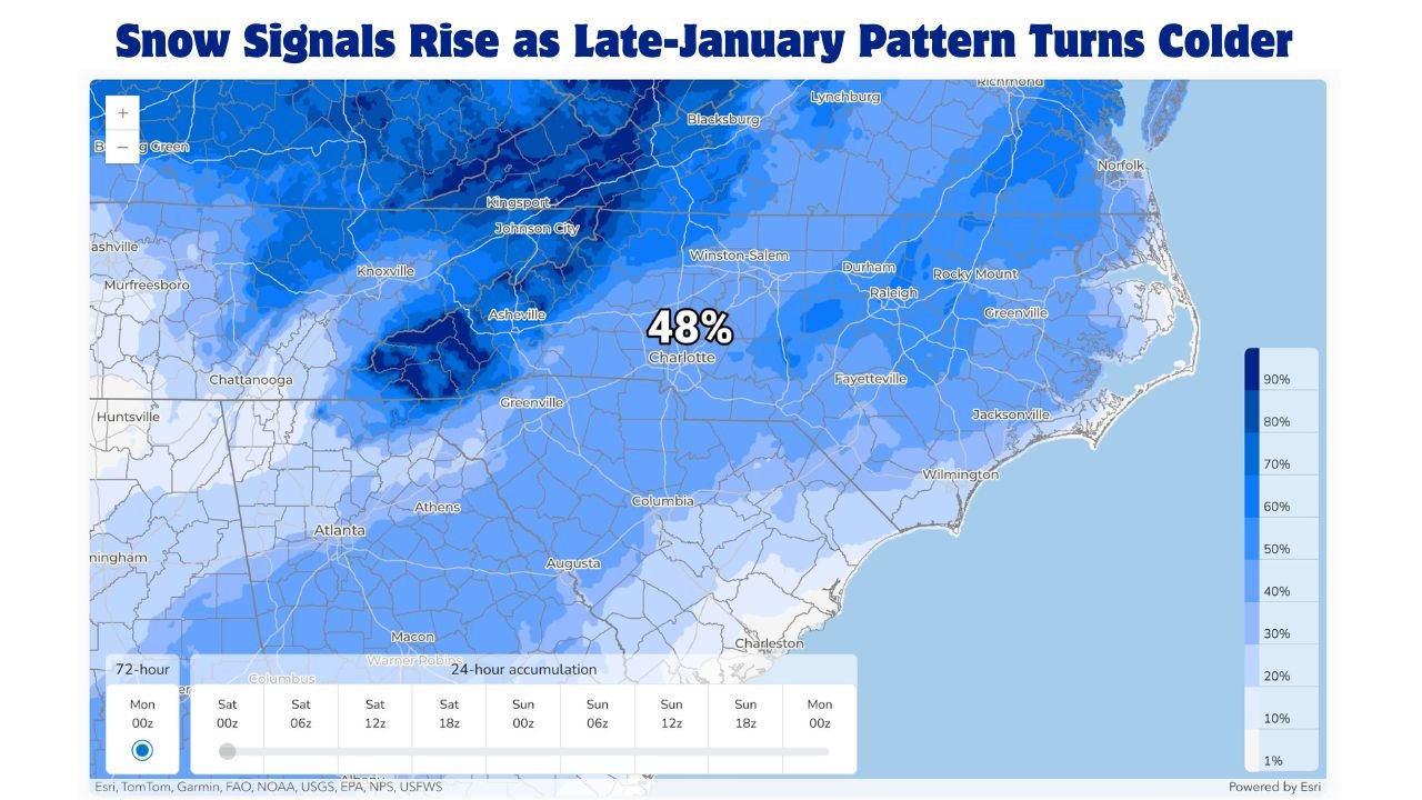
North Carolina and the Piedmont: probabilities show snow is possible, but not locked in
In the Carolinas, the message is uncertainty — but not zero. A set of probability graphics for Charlotte and much of the Piedmont outlines the chances for a Sunday setup, using ensemble guidance rather than hype.
For the Charlotte area, the probabilities show:
- 48% chance of at least a trace (0.1″)
- 26% chance of 1 inch or more
- 18% chance of 2 inches or more
- 4% chance of 4 inches or more
That distribution strongly favors light snow or a glancing accumulation, with the higher totals still possible but low probability. The guidance also notes the higher odds appear north and east of Charlotte, which fits the usual reality: small track shifts can dramatically change who sees meaningful snow.
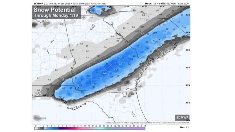
Southeast winter storm signal: from Texas to Maine, but highest confidence corridor may shift
Another graphic breaks down a potential weekend winter storm signal for the Southeast into the Mid-Atlantic and Northeast. It emphasizes that cold air will be in place, and the result depends on where moisture sets up — a key line because that boundary is often what decides “cold and dry” versus “snow/ice and disruptive.”
The same outlook suggests:
- Some snow potential as far southwest as far eastern Texas
- A corridor of higher snowfall confidence stretching from the Florida Panhandle to central New Jersey
- A reminder that this may change as the storm track trend becomes clearer
In short: a broad canvas is being painted, but the details will tighten with time.
Jet stream outlook: colder East, more active storm track late January into early February
A longer-range jet stream pattern outlook through mid-February shows a setup that favors repeated shots of big cold air into the eastern U.S. The commentary tied to the pattern notes that the season hasn’t produced many large systems so far — but that could change as the storm track becomes more active in late January and especially early February.
Within those longer-range hints:
- Potential for over 1 inch of snow as far south as north Georgia, with flurries possible toward the Florida Panhandle
- A signal for 4–6 inches in Kentucky
- A broader “big snow” idea from the Great Lakes into the Northeast, including the possibility of very large totals in the most snow-favored corridors
Long-range snow maps should always be handled carefully, but the pattern takeaway is important: cold air availability + a more active track increases the odds of multiple snow opportunities, not just one.
If you’ve been waiting for winter to “show up,” this is the kind of setup that often delivers — sometimes in bursts, sometimes in major events.
If winter weather affects your travel plans, rehearsals, gigs, or weekend schedules, keep an eye on local forecasts and updates — and share what you’re seeing in your area with us at ChicagoMusicGuide.com.