Georgia, North Carolina, and South Carolina Face Uncertain Snow Potential as Global and Short-Range Models Disagree on Cold Air Reach
ATLANTA, GEORGIA — A developing winter weather system expected to impact parts of the Southeastern United States early next week is presenting a complex forecasting challenge, as major weather models disagree on how far south and inland meaningful snowfall can reach. New ensemble guidance from both global and short-range models shows sharp differences in cold air penetration, moisture alignment, and terrain effects — all key factors that will determine whether this system produces only light snow or a more disruptive winter event.
Early guidance suggests the system will approach the region late Monday into Tuesday, but confidence remains low on final snow amounts, especially across Georgia, the Carolinas, and adjacent inland areas. Meteorologists say the next set of 00z and 12z model runs will be critical in resolving these uncertainties.
Global Models Show Limited Inland Snow Coverage
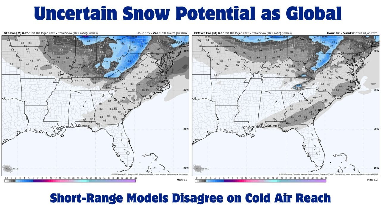
Recent global ensemble guidance, including the GFS and ECMWF ensemble means, currently depicts a more restrained snowfall footprint across the Southeast. These solutions generally keep the coldest air bottled up farther north, resulting in lighter snow accumulations mainly confined to portions of the Ohio Valley, central Appalachians, and higher elevations of the Mid-Atlantic.
In these scenarios, much of Georgia, Alabama, and the Carolinas see only minor snow totals, often under one inch, with some areas showing little to no accumulation at all. This outcome would favor a colder rain or brief snow mix for lower elevations rather than a widespread winter storm.
Forecasters note that global models can sometimes struggle with shallow cold air masses, especially when terrain plays a role in slowing or redirecting that cold air southward.
Short-Range Models Push Snow Farther South and Inland
By contrast, short-range and higher-resolution guidance is more aggressive in driving cold air deeper into the Southeast. Several of these solutions show snow extending farther inland, with pockets of higher accumulations developing along and east of the Appalachian Mountains.
This is where the forecast becomes especially tricky. The mountains can act as a brake on advancing cold air, allowing it to pool and deepen east of the terrain. Short-range models appear to capture this effect more strongly, suggesting that areas of north Georgia, upstate South Carolina, and western North Carolina could see measurable snowfall if moisture overlaps with the colder air.
Ensemble snowfall maps show localized totals exceeding one to two inches in some inland zones under these solutions, which would be enough to impact travel and daily activities.
Lack of Northern High Pressure Adds to Uncertainty
One of the biggest red flags in this forecast is the absence of a strong high-pressure system to the north. Typically, a robust high centered over the Midwest or Northeast helps drive cold air southward and lock it in place. Without it, cold air becomes more vulnerable to being displaced by warmer air aloft.
This setup increases the risk of marginal temperatures, especially near the surface, where a few degrees can mean the difference between accumulating snow and cold rain. Forecasters emphasize that even small shifts in pressure placement or timing could dramatically alter outcomes across the region.
Why the Next Model Runs Matter So Much
Meteorologists are closely watching upcoming 00z and 12z model cycles, which are expected to provide better clarity as the system moves closer and more observational data is ingested. These runs may help determine:
- How effectively cold air can push southward
- Whether moisture arrives early enough to overlap with freezing temperatures
- How terrain influences local accumulation zones
Until then, confidence remains moderate at best, with a wide range of possible outcomes still on the table.
What Residents Should Expect Right Now
At this stage, residents across the Southeast should be prepared for a highly variable winter forecast. Some areas may see little more than flurries, while others — especially inland and higher-elevation locations — could experience light to moderate snowfall.
Forecasters caution against focusing on exact snow totals this far out and instead recommend staying alert to forecast updates over the next 24 to 48 hours as model guidance converges.
As winter weather uncertainty continues to grip the Southeast, the battle between global and short-range forecast models highlights just how delicate this setup remains. Small changes in cold air timing, moisture placement, or pressure patterns could dramatically shift impacts across multiple states. For continued updates on winter weather forecasts, regional impacts, and how changing conditions could affect events and travel, visit ChicagoMusicGuide.com for the latest coverage.