Alabama, Mississippi, and Florida Gulf Coast Face Low-Confidence Snow Risk Saturday Night as NWS Outlines Two Winter Scenarios
MOBILE, ALABAMA — Portions of southern Alabama, southern Mississippi, and the Florida Panhandle could see light accumulating snow or a wintry mix Saturday night, though confidence remains low on how much accumulation will actually occur. New scenario-based guidance released by the National Weather Service Mobile/Pensacola shows a range of outcomes tied closely to how a developing low-pressure system behaves near the northern Gulf of Mexico.
Forecasters stress that while winter weather impacts are not guaranteed, the potential is increasing enough that residents should begin preparing for slick conditions and closely monitor updates.
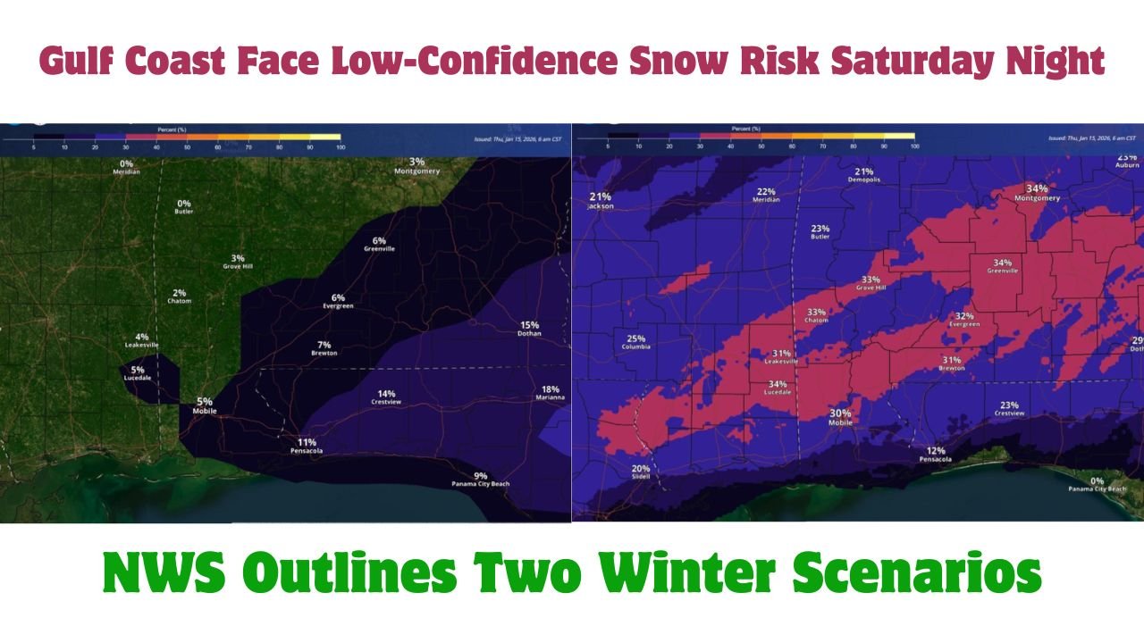
Scenario One: Most Likely Outcome Brings Minimal Accumulation
In the most likely scenario, low pressure either fails to fully organize over the northern Gulf or forms farther south. Under this setup, light rain develops Saturday evening before gradually diminishing overnight.
As colder air filters in late, a transition from rain to a wintry mix or brief snow cannot be ruled out, particularly east of Interstate 65. However, forecasters emphasize that accumulations would remain light, with little to no measurable snow expected for most locations.
Even in this lower-impact scenario, patchy slick spots could still develop late at night, especially on bridges and elevated roadways.
Scenario Two: Less Likely, But Increasing Winter Impact
The second scenario, while less likely at this time, shows a developing low-pressure system over the northern Gulf that allows moisture to linger longer into the overnight hours. In this case, rain Saturday evening could more effectively transition to snow or a wintry mix as temperatures cool.
Higher moisture in the lower and mid-levels of the atmosphere would support locally heavier precipitation, raising the possibility of light snow accumulation across parts of south Alabama, coastal Mississippi, and inland sections of the Florida Panhandle.
Probability graphics indicate moderate chances of at least one inch of snow in a narrow corridor if this scenario materializes, though forecasters caution that this outcome is far from certain.
Why Confidence Remains Low
The uncertainty hinges on where and how quickly the Gulf low forms. Small shifts in storm track, intensity, or timing could dramatically change precipitation type and totals. Marginal temperatures further complicate the forecast, especially near the surface, where just a degree or two could determine whether snow sticks.
Because of these variables, meteorologists describe this as a conditional winter weather setup, not a locked-in snow event.
Potential Impacts If Snow Develops
If accumulating snow does occur, impacts would likely be brief and localized, but even light snow can create problems in areas unaccustomed to winter weather. Slick roads late Saturday night into Sunday morning would be the primary concern, particularly in shaded or elevated areas.
Residents are encouraged to review winter safety plans, limit unnecessary travel during peak impact windows, and stay informed through official updates.
What to Watch Over the Next 48 Hours
Forecasters expect forecast confidence to improve as newer model data refines the evolution of the Gulf system. Updates may adjust snowfall probabilities, impact zones, or timing as the event draws closer.
Until then, officials urge residents not to focus on exact snowfall amounts, but instead remain aware that wintry precipitation is possible, even if totals end up minor.
As Alabama, Mississippi, and the Florida Panhandle monitor a rare Gulf Coast winter setup, the message from forecasters is one of cautious awareness rather than alarm. Conditions could remain mostly wet — or briefly turn wintry — depending on subtle atmospheric changes. For the latest updates on winter weather scenarios, safety guidance, and regional impacts, continue following coverage at ChicagoMusicGuide.com.