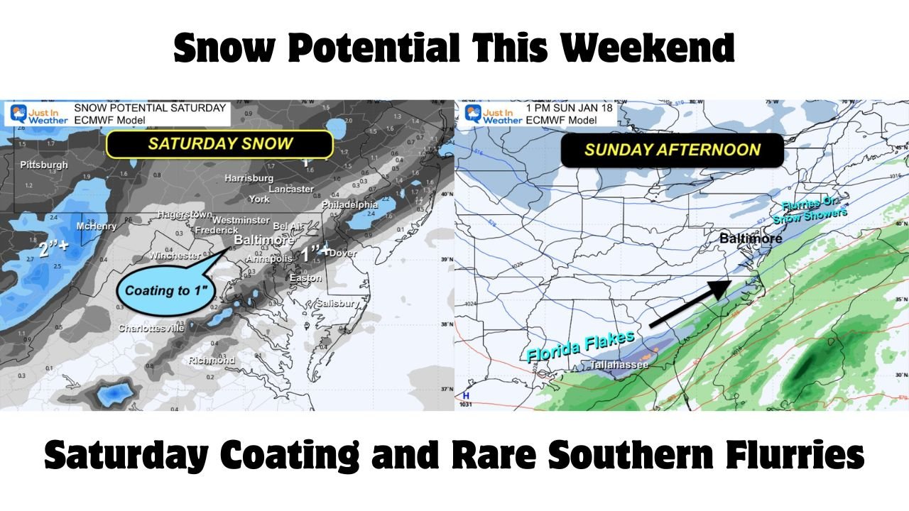
Pennsylvania, Maryland, Delaware, and Florida See Snow Potential This Weekend as ECMWF Highlights Saturday Coating and Rare Southern Flurries
BALTIMORE, MARYLAND — New guidance from the ECMWF computer model is raising attention across a wide stretch of the eastern United States, with Pennsylvania, Maryland, and Delaware now in play for light accumulating snow Saturday, while parts of Florida could see rare snowflakes Sunday. While this is not shaping up to be a major winter storm, forecasters say the setup could be enough to finally break the snow drought in several regions.
Confidence remains moderate to low on exact totals, but the signal for noticeable winter weather is becoming clearer as the weekend approaches.
Saturday Snow Potential Expands Across the Mid-Atlantic
According to the latest ECMWF guidance, much of central and eastern Pennsylvania, central and southern Maryland, and Delaware’s Delmarva Peninsula are now included in a zone capable of seeing a coating to around one inch of snow on Saturday.
The model shows a narrow but well-timed window where cold air and moisture overlap during the afternoon and early evening. Most locations would see light snow, but forecasters note that banding associated with a jet streak aloft could allow a few areas to briefly pick up closer to one inch, particularly south and east of Annapolis into Delmarva and isolated parts of southeastern Pennsylvania.
Snowfall is expected to be light overall, but even small accumulations could be noticeable on grassy surfaces and colder roadways.
Southern Track Clips Maryland and Delmarva
The ECMWF continues to favor a southern storm track that keeps the heaviest precipitation offshore, while still brushing southern Maryland and Delmarva with flurries or snow showers. This setup limits higher totals but keeps much of the region involved in at least light snow or wintry precipitation.
Forecasters caution that a subtle northward or southward shift could change who sees snow versus little impact, reinforcing why accumulation confidence remains limited at this stage.
Why the GFS Is Being Viewed Cautiously
Some guidance from the GFS model continues to show more aggressive snowfall totals, but many forecasters remain hesitant to fully embrace that solution given its recent performance in similar setups. Without stronger support from additional models, confidence remains anchored closer to the ECMWF’s more modest snowfall outlook.
As a result, expectations are being set for light but meaningful snowfall, rather than a widespread disruptive event.
Sunday Brings Rare Snowflakes to Florida
Perhaps the most eye-catching part of the forecast lies farther south. ECMWF projections suggest snowflakes could reach parts of northern Florida on Sunday, with Tallahassee potentially seeing up to two inches of slushy accumulation in a narrow window.
While this outcome remains uncertain, the model shows cold air pressing far enough south to support flurries or light snow showers, a rare sight beneath palm trees. Even if accumulations fall short, the presence of snowflakes alone would make this a notable winter event for Florida.
What to Expect Overall
This weekend’s setup favors light snowfall over a broad area, rather than heavy totals in one location. For many communities in Pennsylvania, Maryland, and Delaware, Saturday could deliver just enough snow to be seen and felt, especially after a relatively quiet winter so far.
Farther south, Florida’s chance at snow remains conditional, but even a brief appearance of flakes would be significant.
As winter weather attempts another push across the East, this weekend may finally bring a long-awaited but modest taste of snow to several states. While impacts should remain limited, changing temperatures and brief bursts of snow could still catch some off guard. For continued updates on snowfall potential, regional impacts, and how evolving conditions may affect weekend plans, stay with ChicagoMusicGuide.com for the latest weather coverage.