Midwest, Southeast and East Coast Brace for Brutal Cold as Winter Pattern Signals Snow Potential Across Illinois, Georgia, Carolinas and Beyond

CHICAGO – A powerful winter pattern is lining up across a large portion of the United States, with Illinois, the Midwest, the Southeast, and the East Coast all facing a stretch of significantly colder-than-normal temperatures next week — and the potential for snow and wintry precipitation in several regions. While exact snowfall amounts are still uncertain, forecasters agree the pattern itself is concerning and worth close monitoring.
Long-range guidance shows winter tightening its grip as Arctic air surges southward, setting the stage for what could become the coldest and most active stretch of the season so far.
A Sharply Colder Pattern Takes Hold Nationwide
Forecast models indicate a dramatic temperature split developing across the country. The western United States trends much warmer than average, while a deep trough settles over the Midwest, Great Lakes, Southeast, and Northeast.
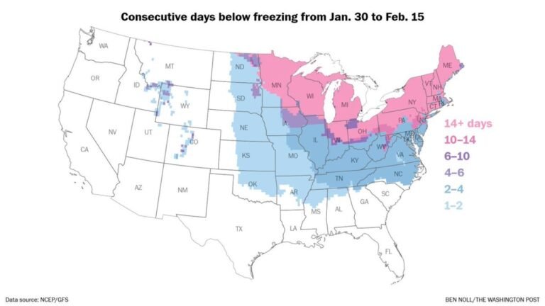
Large portions of Illinois, Indiana, Michigan, Wisconsin, Ohio, Missouri, Georgia, the Carolinas, Tennessee, and the Mid-Atlantic are projected to see temperatures well below normal during the 6–10 day window.
In the coldest core of the air mass, dangerous wind chills could plunge to 40–60 degrees below zero in parts of the Upper Midwest, raising concerns about frostbite and strain on infrastructure.
Why Snow Is Being Watched — But Not Forecast Yet
Meteorologists stress that at this range, the focus is pattern recognition, not snowfall totals.
At 7–10 days out, forecasters are simply identifying whether the atmosphere can support winter weather. Right now, the answer is yes — particularly across the Southeast and southern Appalachians, where cold air availability is often the limiting factor.
As the window narrows to 5–7 days, attention shifts to trends:
- Are multiple models agreeing?
- Is the storm track becoming more consistent?
- Is cold air arriving at the right time?
Only inside 3–5 days can forecasters realistically assess whether precipitation would fall as rain, snow, sleet, or ice — and whether meaningful impacts are possible.
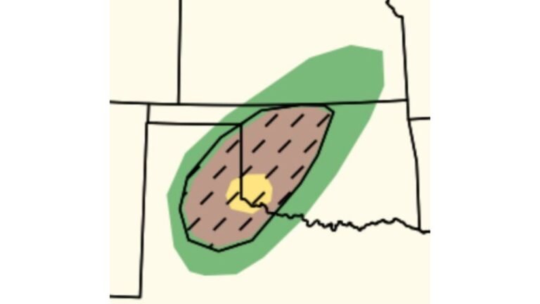
Southeast Snow Potential: Georgia, Carolinas in Focus
Current signals suggest that Georgia, South Carolina, North Carolina, and parts of Alabama could see opportunities for wintry precipitation if moisture and cold air overlap correctly.
Earlier short-range systems already show:
- Central Georgia with localized snow potential
- South Georgia and parts of Florida’s Panhandle seeing advisory-level snow mainly on grassy surfaces
- Carolinas sitting in a favorable zone for future systems if timing improves
However, forecasters caution that temperature profiles in the Southeast are notoriously sensitive, sometimes changing precipitation type with a difference of just one or two degrees.
Midwest Impacts: Cold First, Snow Possible Later
For Illinois and the central Midwest, the immediate concern is extreme cold, not snow totals.
As Arctic air settles in:
- Daytime highs may struggle well below seasonal averages
- Overnight lows could dip into dangerous territory
- Wind chills may become life-threatening in exposed areas
Any storm that interacts with this cold air later next week could quickly become impactful, but at this stage, the cold itself is the headline.
What This Means for Travel and Planning
Because confidence in the pattern is high — even if specifics are not — residents should begin preparing now:
- Monitor updates daily
- Avoid overreacting to single model runs
- Plan flexibility into travel late next week
- Prepare for extreme cold exposure, especially pets and vulnerable populations
Forecasters emphasize this is not panic weather, but it is not something to ignore either.
Bottom Line
✔ A cold, active winter pattern is setting up
✔ Midwest and Southeast both face elevated winter risks
✔ Snow is possible, but details remain uncertain
✔ Extreme cold is increasingly likely next week
✔ Confidence will improve rapidly inside 5 days
Winter is clearly not finished, and the atmosphere is signaling more opportunities ahead. Updates will become sharper as the forecast window tightens.
Stay informed, stay flexible — and keep checking back with ChicagoMusicGuide.com for the latest winter weather updates as this developing pattern unfolds.