Hazardous Cold and Heavy Snow Threatens Montana, North Dakota, South Dakota, Minnesota, Wisconsin, Michigan, Illinois, Indiana, Ohio, and Pennsylvania This Week
UNITED STATES — A widespread and dangerous winter weather pattern is expected to develop across large portions of the country between January 21 and January 25, with hazardous cold and heavy snow impacting multiple regions from the Northern Plains into the Midwest and Great Lakes.
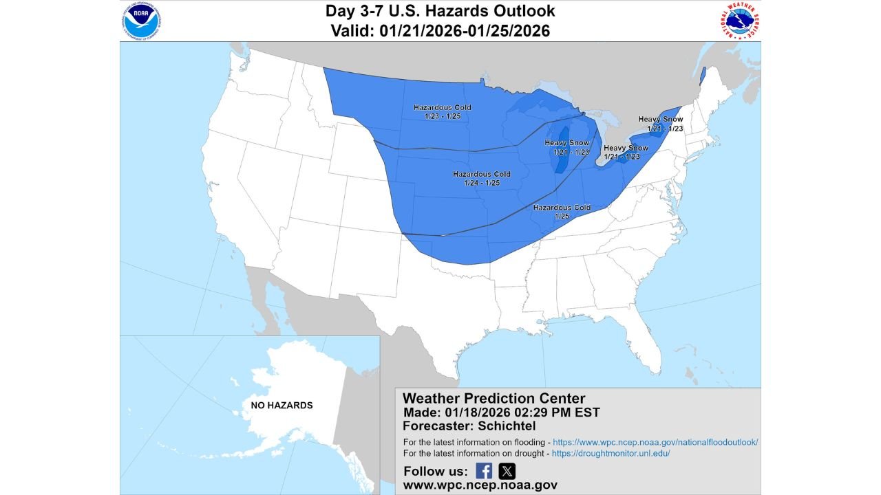
The latest Day 3–7 U.S. Hazards Outlook highlights a broad zone of dangerously cold Arctic air pushing south from Canada, combined with multiple storm systems capable of producing heavy snowfall, especially downwind of the Great Lakes. This pattern marks one of the most significant winter threats of the season so far.
Hazardous Arctic Cold Expands Across the Central United States
A strong Canadian high-pressure system is forecast to drive subfreezing air deep into the Lower 48, placing Montana, North Dakota, South Dakota, Nebraska, Kansas, Iowa, Minnesota, Wisconsin, Illinois, Missouri, Michigan, Indiana, and Ohio under a prolonged cold threat.
In many of these states, daytime temperatures may struggle to rise above single digits, while overnight lows plunge well below zero. Wind chills could become life-threatening, particularly across the northern tier, where prolonged exposure outdoors may lead to frostbite in minutes.
This cold is not a brief shot — it is expected to linger for several days, increasing risks to infrastructure, livestock, and energy demand.
Heavy Snow Risk Focused on the Midwest and Great Lakes
Within the Arctic air mass, multiple weather disturbances are expected to track across the region, enhancing snowfall potential across Minnesota, Wisconsin, Michigan, northern Illinois, northern Indiana, and Ohio.
The highest confidence for heavy snow currently exists in areas favored by lake-effect enhancement, where persistent cold northwest flow could generate long-duration snow bands. Snowfall totals in these regions may climb rapidly once bands become established.
Travel disruptions are likely, especially during overnight and early morning hours when temperatures are coldest and road treatment becomes less effective.
Why This Pattern Is Concerning
This setup combines several high-impact winter elements:
- Sustained Arctic cold, not just a brief cold snap
- Multiple snow opportunities, not a single storm
- Wind-driven snow, increasing blowing and drifting
- Extended duration, stressing power and heating systems
Even areas that miss major snowfall could still experience dangerous cold exposure risks, icy roads, and frozen pipes.
What Happens Next
Forecast confidence is high regarding the cold, but snowfall placement will depend on the exact track and timing of individual systems. Small shifts could dramatically change which communities receive the heaviest snow.
Residents across the affected states should prepare for rapidly changing conditions, stay updated on local advisories, and plan for possible travel delays.
Bottom Line
A multi-day winter hazard period is shaping up across much of the central and northern United States. The combination of hazardous cold and heavy snow makes this a high-impact weather pattern that should not be ignored.
ChicagoMusicGuide.com will continue monitoring this evolving setup and provide updates as confidence increases and impacts become clearer.