Missouri, Illinois, Indiana, Ohio, Kentucky, and Tennessee Under Watch as Jan. 24–26 Winter Storm Signals Snow and Ice Threats
UNITED STATES — A potential large winter storm system is beginning to take shape in forecast guidance for next weekend, January 24–26, with model trends indicating a broad swath of snow and ice stretching from the Plains through the Ohio Valley and into the Mid-Atlantic and Southeast. While exact impacts are still uncertain, meteorologists say the overall signal for a widespread winter weather event is becoming increasingly clear.
Forecast ensembles show a developing low-pressure system emerging over the Southwest and southern Plains late next week, then tracking east-northeast across the central United States. This setup would place multiple states under the threat of accumulating winter precipitation, though the precise storm track will determine which areas see heavy snow versus a wintry mix.
Storm Setup and Current Model Trends
Latest ensemble guidance suggests the storm will begin organizing Thursday into Friday, intensifying as it moves across the central Plains and toward the Mississippi and Ohio Valleys. By Saturday into Sunday, the system could reach the Mid-Atlantic and Southeast, expanding the impact zone significantly.
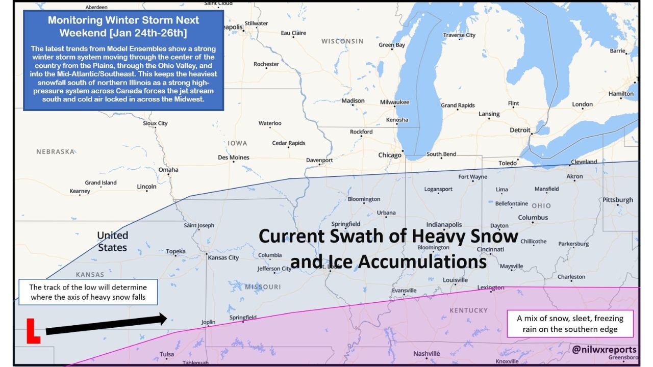
A key factor in this forecast is a strong high-pressure system positioned to the north, likely across Canada. This high pressure is expected to push the jet stream south, favoring a more southern storm track. As a result, the heaviest snow axis is currently projected south of northern Illinois, a detail that has important implications for the Midwest.
Snow Corridor Focused on the Ohio Valley
Based on current projections, the primary snow corridor extends from Missouri through central and southern Illinois, into Indiana, Ohio, and points east. This region sits north of the storm’s surface low, where colder air would support predominantly snow.
Forecasters stress that while moderate to locally heavy snow is possible in this zone, extreme snowfall totals are not favored at this time. Instead, a more typical large-system outcome—several inches of snow spread over a wide area—appears more likely if current trends hold.
Ice and Mixed Precipitation Threat to the South
South of the main snow band, warmer air aloft could introduce sleet and freezing rain, particularly across parts of Kentucky, Tennessee, Arkansas, and the Deep South. The southern edge of the storm is expected to feature a complex precipitation transition zone, where even small shifts in track could dramatically alter impacts.
These areas may face travel disruptions and power-related concerns if ice accretion becomes significant. At this stage, forecasters caution that ice placement remains one of the most uncertain elements of the forecast.
What This Means for Illinois and the Midwest
Despite widespread social media speculation showing a storm “slamming” the Midwest, northern Illinois is currently on the northern fringe of the precipitation shield. If the southern track verifies, areas near Chicago and far northern Illinois could see little snow or possibly none at all, while heavier impacts remain farther south.
Central and southern Illinois, however, remain within the favored snow zone under current ensemble guidance. Forecasters emphasize that any claim of guaranteed heavy snow for northern Illinois at this time is not supported by the data.
Forecast Confidence and Key Uncertainties
While confidence is growing that a large storm system will exist, confidence in exact snowfall and ice totals remains low. Small changes in:
- The position of the surface low
- The strength of northern high pressure
- Temperature profiles aloft
could all shift the heavy snow and ice axis hundreds of miles north or south.
Because the storm is still several days away, daily forecast updates will be critical as higher-resolution data becomes available.
What to Watch Going Forward
Residents across the central and eastern United States should monitor forecasts closely through the upcoming week. Key signals to watch include whether models continue favoring a southern track or trend northward, which would significantly change impacts for the Midwest.
For now, the takeaway is clear: a high-impact winter system is possible, but final details are far from locked in.
As meteorologists refine the forecast and confidence improves, staying informed will be essential. For continued winter weather updates, forecast breakdowns, and regional impact coverage, visit ChicagoMusicGuide.com.