Texas, Tennessee, Kentucky, Virginia, North Carolina and Mid-Atlantic States Face High-Impact Winter Storm With Snow, Ice and Arctic Cold Late January
UNITED STATES — A large and potentially high-impact winter storm is coming into focus for the Southern Plains, Mid-South, Appalachians, and Mid-Atlantic as we move toward the January 24–26 timeframe, according to a growing collection of national weather models and probability outlooks. While confidence is still evolving, recent data shows a classic cold-air-meets-Gulf-moisture setup that could deliver a wide swath of snow, ice, and dangerous cold across several regions.
Developing Winter Storm Pattern Across Multiple States
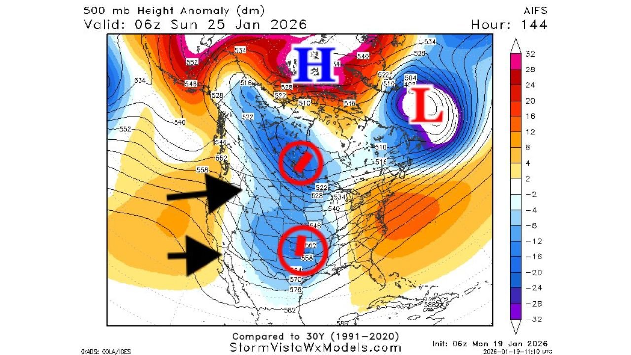
Forecast guidance shows a strong surge of Arctic air diving southward from Canada, driven by a pronounced high-pressure system that may settle over the northern United States and New England. At the same time, a developing storm system is expected to track from Texas and the Gulf Coast northeastward, tapping into deep moisture.
This combination raises concern for a large snow swath north of the storm track and a dangerous ice zone to the south, especially across Texas, Arkansas, Tennessee, Kentucky, and parts of the Deep South. Several model scenarios indicate this storm could stretch thousands of miles, impacting travel corridors from the Southern Plains through the Ohio Valley and into the Mid-Atlantic.
While exact placement remains uncertain, forecasters note that the overall pattern is “ripe” for a significant winter weather event.
Snow Probabilities and Ice Concerns by Region
Long-range probability maps show moderate to high chances for at least three inches of snow across a broad corridor that includes Oklahoma, Arkansas, Tennessee, Kentucky, West Virginia, Virginia, Pennsylvania, and Maryland. Some areas within this zone show probabilities exceeding 60–80 percent, signaling that accumulating snow is a realistic concern if the current trend holds.
South of the main snow band, ice accumulation is increasingly likely. Forecasts suggest freezing rain and sleet could impact North and Central Texas, northern Louisiana, Mississippi, Alabama, and parts of Georgia, especially during the early stages of the storm as cold air undercuts warmer air aloft.
Ice accumulation, even light amounts, can cause power outages, tree damage, and extremely hazardous travel, making this aspect of the storm especially concerning.
Timing and Forecast Confidence
At this distance, overall forecast confidence is moderate, roughly 2.5 out of 5, according to meteorological assessments shared with the latest model discussions. What is becoming clearer is the timing window, with impacts most likely beginning late Friday, January 24, and continuing through Saturday and Sunday.
What remains uncertain is where the storm’s low-pressure center tracks, which will ultimately decide who sees heavy snow, who deals with ice, and who may end up with mostly rain. Even small shifts north or south could dramatically change impacts for cities across the region.
Cold Blast and Post-Storm Impacts
Behind the storm, a strong Arctic blast is expected to settle in, bringing sub-freezing temperatures well into the South. This could prolong travel issues, worsen icy road conditions, and increase risks to pipes, pets, and unprotected plants across multiple states.
In some areas, temperatures may remain below freezing for extended periods, raising concerns for infrastructure strain and delayed recovery even after precipitation ends.
What Residents Should Do Now
While it is still early for precise snowfall totals or ice amounts, residents across the impacted states should begin monitoring forecasts closely through the week. This is especially important for those with weekend travel plans, outdoor events, or critical work schedules.
Preparation now—such as reviewing emergency supplies, planning flexible travel options, and staying aware of changing forecasts—can help reduce risk if the storm strengthens as expected.
As more data becomes available, confidence will improve, and clearer impact zones will emerge.
For continued updates on developing winter weather threats, forecast breakdowns, and regional impacts, visit ChicagoMusicGuide.com for the latest weather coverage and real-time updates.