Major Late-January Winter Storm and Arctic Outbreak Could Bring Snow, Ice, and Historic Cold From Texas to Florida
UNITED STATES — The final days of January are shaping up to deliver one of the most volatile weather patterns of the season, as two major winter storms and multiple arctic air outbreaks line up across the country. Forecast data shows a high likelihood of a significant winter storm this weekend, followed by a surge of exceptionally cold arctic air that could push historic cold temperatures as far south as Florida next week.
A Complex, High-Impact Winter Setup Takes Shape
Meteorologists describe the current pattern as a classic high-risk setup, with dense arctic air pressing southward while a developing storm system rides along the temperature boundary. In these scenarios, precipitation often transitions through snow, sleet, freezing rain, and rain, sometimes within a relatively short distance.
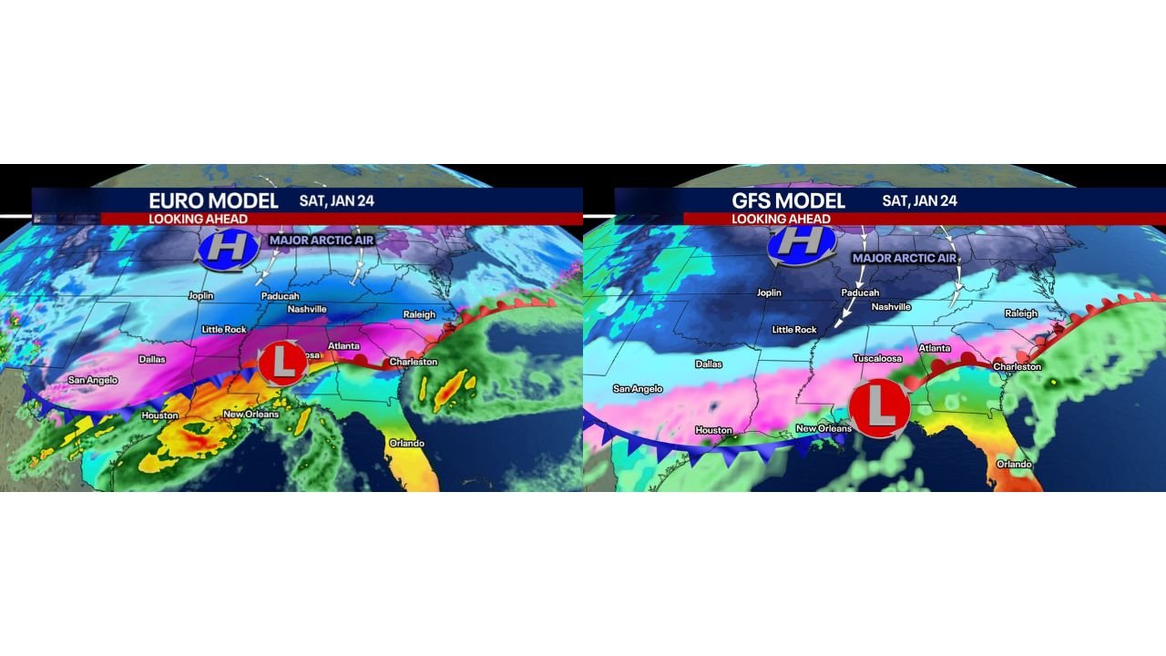
Both major global models — the European (EURO) and GFS — agree on a major storm but differ on the exact placement of the heaviest impacts. That difference is critical, as it determines where heavy snow bands, ice storms, and cold rain ultimately set up.
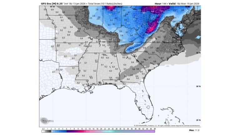
EURO Model Signals Heavy Snow Along the I-40 Corridor
Under the European model scenario, the storm track favors a major snowstorm along the I-40 corridor, stretching from parts of Texas through Arkansas, Tennessee, and into the Carolinas. Snowfall totals in this scenario could exceed 6 inches, with some areas potentially seeing double-digit accumulations.
As the storm moves east, the EURO solution also introduces a significant ice storm threat across portions of the Deep South, including areas from Texas to Georgia, as warm air aloft overrides entrenched cold air near the surface. Severe thunderstorms would remain confined closer to the Gulf Coast and I-10 corridor, south of the primary winter hazards.
GFS Model Pushes Cold and Impacts Farther South
The GFS model paints a more aggressive picture of the arctic air, driving the cold farther south and shifting the entire storm axis accordingly. In this scenario, snow, ice, and rain zones all slide south, increasing winter weather risks across parts of the Deep South that rarely see significant winter storms.
Forecasters note that arctic air is extremely dense and is often underrepresented by models several days out. Historically, this can lead to storms being suppressed farther south than originally projected — a detail that remains under close watch.
Snow and Ice Both Likely, Placement Still Uncertain
Despite model differences, confidence is growing that a major winter storm is likely Saturday through Sunday (January 24–25). Both snow and ice appear probable somewhere across the southern and southeastern United States, but exact placement remains difficult this far ahead of the event.
Small temperature shifts could dramatically alter outcomes, turning a heavy snow event into a crippling ice storm, or vice versa. This uncertainty is typical in southern winter weather setups and is why forecasters emphasize preparation over pinpoint totals at this stage.
Arctic Blast After the Storm Could Be Historic
Once this storm exits, attention quickly turns to the next arctic outbreak, which may be even more significant. Forecast guidance suggests some of the coldest air in years could pour into the entire eastern United States, with temperatures plunging well below seasonal averages.
Of particular note is the potential for record-setting cold reaching into Florida, a rare occurrence even during strong winter patterns. This cold blast could also set the stage for another winter storm in the Southeast 8 to 10 days later, keeping winter weather threats active into early February.
Why This Pattern Demands Close Attention
This is not a typical single-storm setup. The combination of multiple winter systems, arctic air intrusions, and model uncertainty creates an extended period of elevated risk. Impacts could include dangerous travel, power outages from ice accumulation, and unusually cold temperatures affecting infrastructure unaccustomed to prolonged freezes.
Forecasters caution that while some areas may ultimately see only cold rain, the worst-case scenario involves crippling ice storms capable of causing outages lasting days, and in isolated cases, longer.
What to Expect Next
More refined snowfall and ice forecasts will become available as the weekend approaches. Until then, residents across the South, Southeast, and Gulf Coast states are encouraged to monitor updates closely and prepare for rapidly changing conditions.
As the nation heads into what could be a remarkable and disruptive end to January, staying informed will be essential. For ongoing coverage of major winter storms, arctic outbreaks, and how these weather patterns could affect travel and events nationwide, continue following updates on ChicagoMusicGuide.com.