Major Winter Storm Brings Widespread Ice, Snow, and Travel Hazards Across Northern Louisiana, East Texas, and Southern Arkansas This Weekend
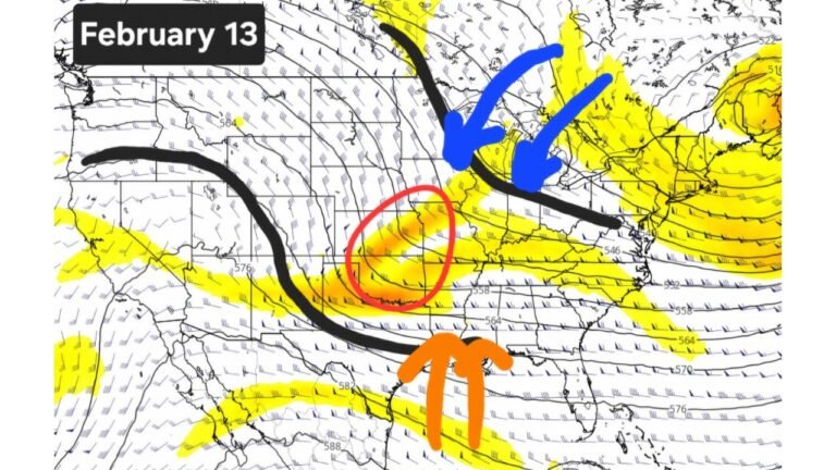
SHREVEPORT, LOUISIANA — A Winter Storm Warning and Winter Storm Watch are in effect across much of northern Louisiana, east Texas, and parts of southern Arkansas as a powerful winter system moves through the region from Friday evening through Sunday noon. Forecast data indicates widespread freezing rain, significant ice accumulations, and snow and sleet totals increasing northward, creating dangerous travel conditions and a heightened risk of power outages.
Winter Storm Warning and Watch Areas Explained
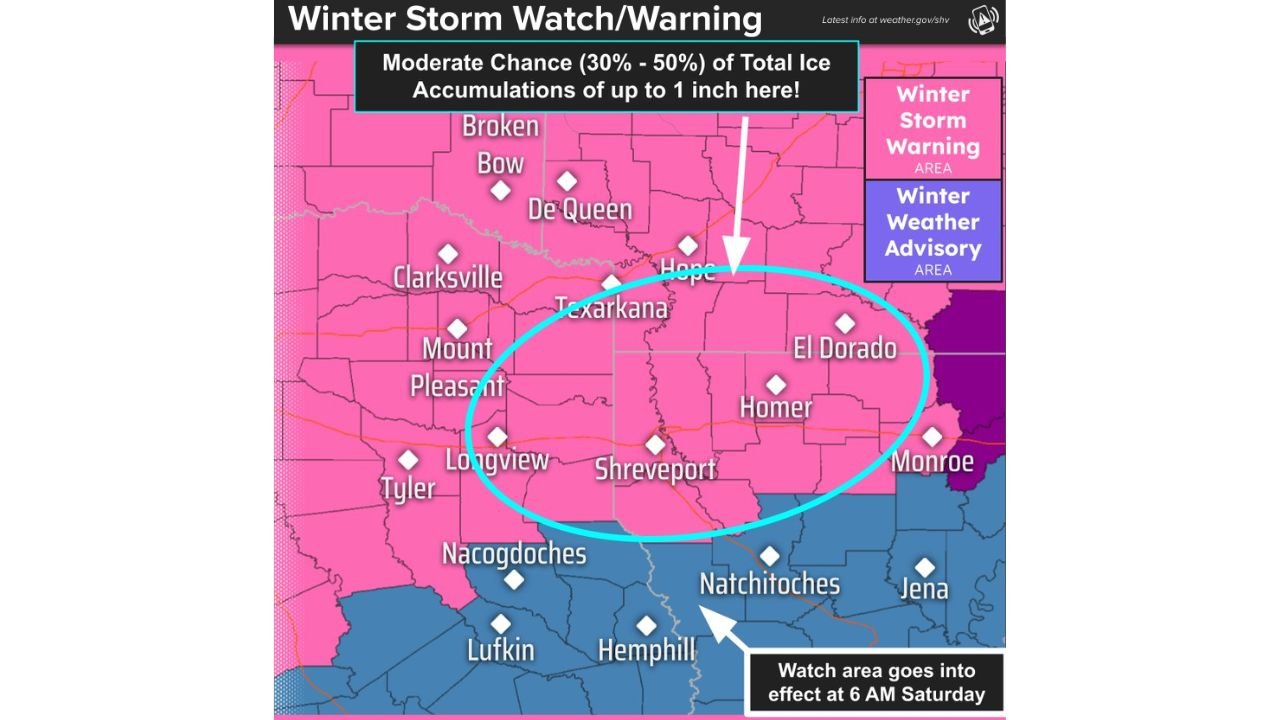
The Winter Storm Warning currently covers the majority of the forecast region, including cities such as Shreveport, Texarkana, El Dorado, Mount Pleasant, and Longview. These areas are expected to see the most impactful icing and hazardous conditions.
Farther south, a Winter Storm Watch remains in effect for portions of deep east Texas and southern Louisiana, including areas near Lufkin, Hemphill, and Natchitoches. Forecasters note that these zones could be upgraded to a warning if freezing rain becomes more persistent overnight Saturday into Sunday.
The advisory timeline shows the storm beginning around 6:00 PM Friday, intensifying overnight, and continuing through Sunday midday, with impacts lingering even after precipitation ends.
Ice Accumulation Poses Major Threat
Forecast models show freezing rain and ice accumulation as the primary hazard across much of the region. The most likely ice totals include:
- 0.25 to 0.50 inches across portions of northeast Texas, southwest Arkansas, and northwestern Louisiana
- 0.50 to 0.75 inches around Shreveport, Longview, Texarkana, and surrounding communities
- 0.75 to 1.00 inch possible in parts of northeast Louisiana, including areas near Monroe and Jonesboro
Meteorologists also highlight a 30% to 50% chance of localized ice totals approaching one inch, which would be enough to bring down trees, snap power lines, and cause prolonged outages. Even lower-end ice amounts can create extremely slick roads, bridges, and walkways.
Snow and Sleet Increase Across Northern Zones
While ice dominates farther south, snow and sleet totals increase across the northern portions of the region, particularly near the Arkansas border. Forecast snowfall and sleet amounts include:
- 3 to 4 inches near Broken Bow, Oklahoma
- 2 to 3 inches across Clarksville, Texarkana, Hope, and El Dorado
- 1 to 2 inches near Mount Pleasant, Shreveport, and Longview
- Less than 1 inch across central Louisiana locations such as Natchitoches and Jena
Forecasters stress that exact amounts will vary sharply over short distances, depending on how long temperatures remain below freezing during heavier precipitation bands.
Timeline of Impacts Through the Weekend
The storm is expected to follow a multi-phase timeline:
- Friday evening: Precipitation develops as temperatures fall, with freezing rain beginning in northern zones
- Overnight Friday into Saturday: Ice accumulation increases rapidly, especially on elevated surfaces
- Saturday: Periods of freezing rain, sleet, and snow continue; travel conditions deteriorate
- Saturday night into Sunday morning: Additional icing possible, particularly in warning areas
- Sunday midday: Precipitation tapers off, but dangerous conditions persist due to lingering ice and snow
Officials caution that road conditions may worsen even after precipitation ends, as temperatures remain cold and untreated surfaces refreeze.
Travel, Power, and Safety Concerns
The expected combination of ice, sleet, and snow presents multiple risks:
- Travel may become nearly impossible, especially on bridges and overpasses
- Power outages are likely, with ice accretion stressing trees and utility lines
- Emergency response times could be delayed due to hazardous roads
- Walking surfaces will be extremely slick, increasing fall-related injuries
Residents are urged to avoid unnecessary travel, prepare for extended power outages, and ensure emergency supplies are available, including food, water, medications, and alternative heat sources used safely.
Why This Storm Is Particularly Dangerous
Meteorologists emphasize that ice storms often cause more damage than snowstorms in the southern U.S. Even a quarter inch of ice can lead to significant infrastructure damage, while half an inch or more dramatically increases the risk of widespread outages and long-term recovery issues.
The current forecast shows ice accumulation spread across a large area, rather than confined to narrow corridors, raising concerns for regional impacts rather than isolated disruptions.
As this winter storm unfolds, continued updates and advisories will be critical for residents across Louisiana, Texas, and Arkansas.
As communities across the region brace for this impactful winter weather, staying informed and prepared will be essential for safety and recovery. For ongoing weather updates, storm coverage, and regional alerts, visit ChicagoMusicGuide.com.