Western Piedmont North Carolina Faces Dangerous Freezing Rain as Ice Storm Spreads Into Appalachian Mountains
NORTH CAROLINA — A dangerous winter weather transition is unfolding across the western Piedmont of North Carolina, where snow is rapidly changing to freezing rain and sleet, creating a growing threat of ice accumulation, hazardous travel, and potential power outages late Saturday night and into early Sunday.
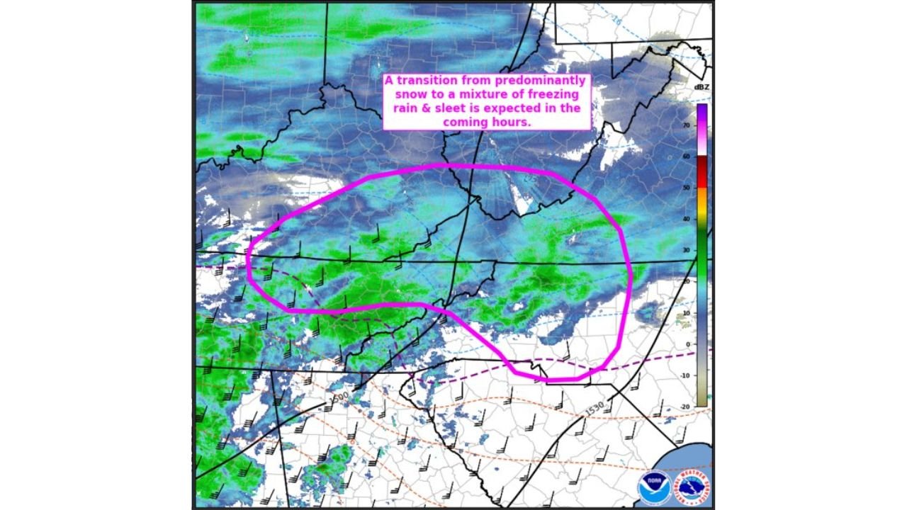
According to the Storm Prediction Center, a mesoscale discussion has been issued highlighting freezing rain rates of 0.05 to 0.1 inches per hour, especially from the western Piedmont into the foothills and higher elevations of the Appalachian Mountains. This rate is sufficient to cause rapid ice buildup on roads, trees, and power lines.
What’s Happening Right Now
Radar and surface observations show a north- and east-moving band of wintry precipitation, driven by warm air aloft overrunning sub-freezing surface temperatures. Areas that initially experienced snow are now transitioning to sleet and freezing rain, increasing the risk of ice rather than snow accumulation.
Meteorologists warn that this changeover significantly raises the danger level, as freezing rain adheres to surfaces much faster than snow and is harder to treat on roadways.
Timing and Duration
- Freezing rain intensifying: Late evening through overnight
- Greatest impact window: Next 3–5 hours
- Conditions improving: Gradually after daybreak as precipitation shifts east
Despite lighter precipitation rates later, even short bursts of freezing rain can cause serious impacts once ice begins accumulating.
Most Impacted Areas
The highest risk zone includes:
- Western Piedmont communities
- Foothills of the Blue Ridge
- Lower elevations transitioning into the southern Appalachians
These areas are especially vulnerable due to elevated terrain, colder surface temperatures, and prolonged exposure to freezing rain.
Expected Impacts
Residents should prepare for:
- Ice-covered roads and bridges
- Severely reduced visibility
- Downed tree limbs
- Localized power outages
- Potential road closures overnight
Emergency managers emphasize that travel conditions may deteriorate quickly, even where roads initially appear wet rather than icy.
Safety Guidance
Officials urge residents to:
- Stay indoors if possible
- Delay travel until conditions improve
- Slow down and allow extra stopping distance if driving is unavoidable
- Prepare for potential power interruptions
Why This Matters
Freezing rain rates near 0.1 inches per hour are often associated with significant infrastructure strain, especially in areas with trees already burdened by earlier snow or sleet. Even minor additional ice can trigger widespread impacts.
Stay alert and monitor local advisories as conditions continue to evolve overnight. For continued weather updates and regional impact coverage, follow ChicagoMusicGuide.com and share this update with anyone in the affected areas who may need to prepare.