Ice Storm and January Tornado Risk Collide Across Louisiana, Mississippi, Alabama, and Florida as Dangerous Storm System Splits the South
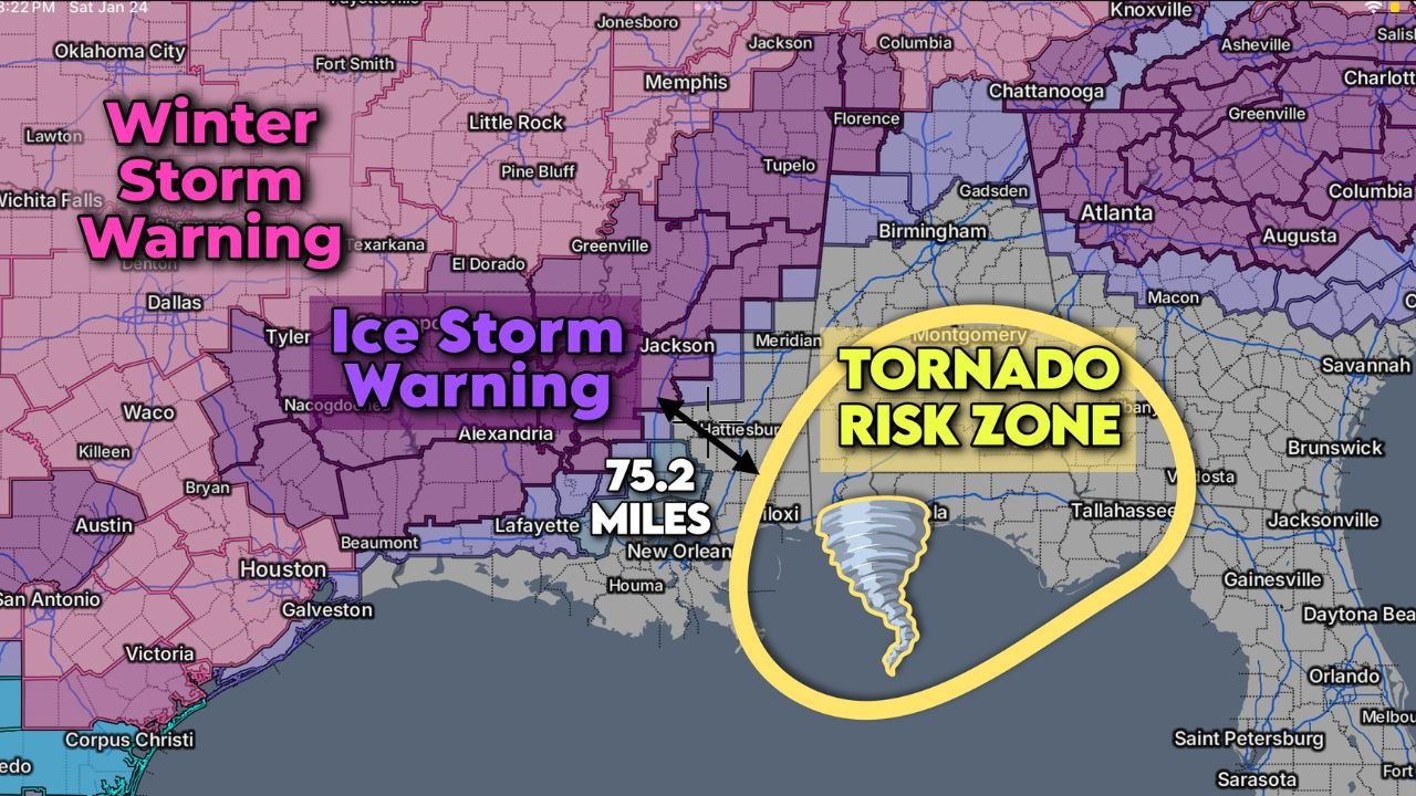
UNITED STATES — A powerful and highly unusual winter storm system is creating a dangerous split across the Deep South, with crippling ice and winter storm warnings stretching across parts of Texas, Louisiana, Arkansas, and Mississippi, while a rare January tornado risk develops less than 80 miles to the east across Alabama, Georgia, and northern Florida. Meteorologists say the setup is extreme, highlighting how sharply different hazards can coexist within a short distance.
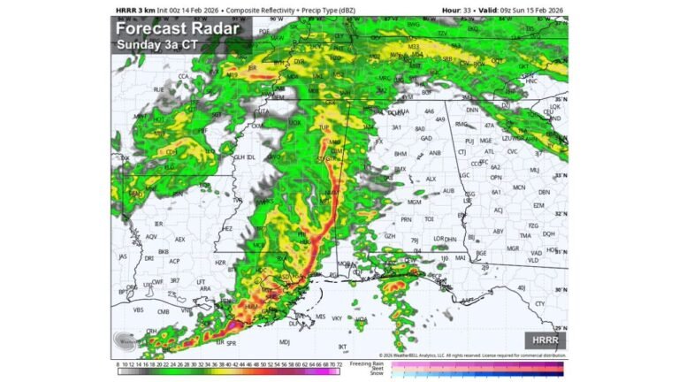
The latest weather maps show Ice Storm Warnings dominating central and northern Louisiana and western Mississippi, while a separate zone of severe thunderstorms capable of producing tornadoes emerges across the eastern Gulf Coast states. The proximity of these threats is what makes this system particularly concerning.
Ice Storm Warnings Stretch Across the Lower Mississippi Valley
Large portions of Louisiana and Mississippi are currently under Ice Storm Warnings, with freezing rain and sleet expected to accumulate on roadways, trees, and power lines. Areas near Alexandria, Lafayette, Jackson, and Greenville are especially vulnerable to prolonged icing.
Forecast models indicate:
- Significant ice accretion capable of snapping tree limbs
- Widespread power outages due to ice-loaded power lines
- Hazardous travel conditions, with untreated roads becoming impassable
Winter Storm Warnings extend farther west into Texas and northward into Arkansas, where colder air dominates the system. This side of the storm is driven by entrenched Arctic air, locking surface temperatures below freezing for extended periods.
Tornado Risk Emerges Just Miles to the East
What makes this storm exceptional is the sharp transition from winter weather to severe weather in a remarkably short distance. Meteorologists note that only about 75 miles separate the ice storm zone from the tornado risk zone, an unusually tight gradient for hazards of this magnitude.
Across southern Mississippi, Alabama, and the Florida Panhandle, warmer air surging northward from the Gulf of Mexico is interacting with intense wind shear. This creates conditions favorable for rotating thunderstorms, even in mid-winter.
Forecasters warn that:
- Isolated but potentially strong tornadoes cannot be ruled out
- Storms may develop quickly with limited warning time
- Nighttime storms could increase risk due to reduced visibility
Cities including Mobile, Montgomery, Tallahassee, and parts of southern Georgia sit within the highlighted tornado risk area.
Why This January Setup Is So Unusual
January tornado threats are rare but not unheard of in the Deep South. However, having severe winter ice storms and tornado-capable thunderstorms occurring simultaneously within the same regional system is highly uncommon.
This setup is driven by:
- A deep upper-level trough plunging cold air into the southern Plains
- Strong southerly winds aloft, enhancing wind shear
- A sharp surface temperature boundary separating freezing rain from warm, unstable air
The result is a meteorological “knife edge,” where conditions change dramatically over short distances.
Travel and Infrastructure Impacts Expected
The collision of winter and severe weather threats is likely to strain emergency services and infrastructure across multiple states. Power crews in Louisiana and Mississippi may face difficult access conditions due to ice-covered roads, while emergency managers in Alabama and Florida prepare for fast-moving severe storms.
Residents are urged to:
- Avoid unnecessary travel in ice storm areas
- Secure loose outdoor items in tornado-prone zones
- Have multiple ways to receive weather warnings, especially overnight
Air and ground travel across the Gulf South may also experience disruptions as airports and highways deal with rapidly changing weather hazards.
What Comes Next as the System Evolves
Forecast guidance suggests the storm system will gradually move east, but impacts will linger. Ice accumulations may take days to fully melt in colder regions, while the severe weather threat could shift toward the eastern Southeast and Atlantic coastal areas.
Meteorologists continue to monitor whether additional tornado watches or ice storm extensions become necessary as the system evolves. Even small changes in temperature could significantly alter where freezing rain ends and severe thunderstorms begin.
As this rare winter system continues to unfold, it underscores how volatile and unpredictable mid-winter weather can become across the southern United States. For continued updates on major weather events, storm impacts, and regional safety information, visit ChicagoMusicGuide.com.

