Catastrophic Ice Storm Spans Texas, Louisiana, Mississippi, Alabama, Tennessee, Georgia, and the Carolinas as Mississippi Sees 2.5 Inches of Ice in 24 Hours
UNITED STATES — A historic and catastrophic ice storm is unfolding across the southern and eastern United States, with a 1,400-mile-long swath of freezing rain developing over the past 24 hours. The most extreme impacts are centered in north and northeastern Mississippi, where ice accumulations between 2 and 2.5 inches have been confirmed, placing the region in what meteorologists describe as a high-end, life-disrupting ice event.
The ice corridor extends from southeast Texas, across Louisiana, Mississippi, Alabama, Tennessee, and Georgia, and into parts of the Carolinas, creating one of the most expansive freezing rain events observed in recent years.
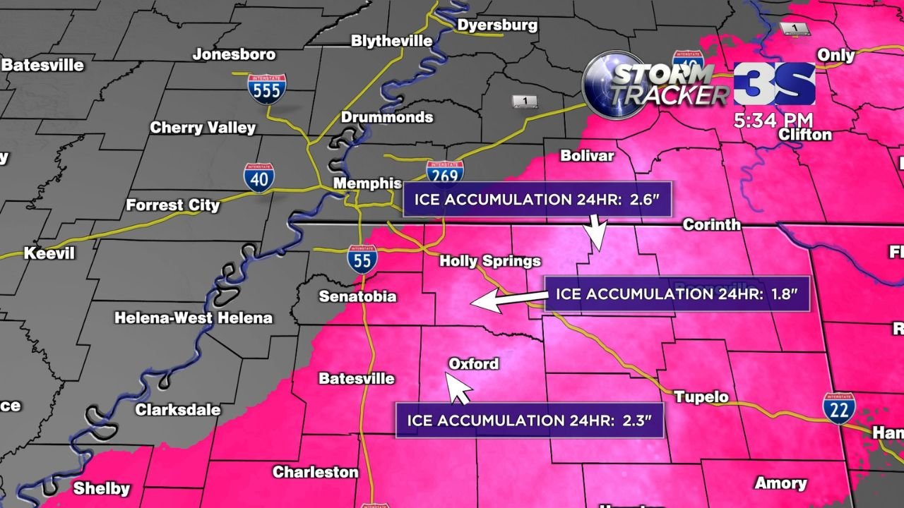
North and Northeastern Mississippi at the Epicenter of the Ice Storm
Data analyzed from storm tracker graphics and regional accumulation maps show north Mississippi taking the brunt of the storm. Communities near Holly Springs, Oxford, Batesville, Tupelo, and Corinth reported ice accretion exceeding two inches in less than a day.
Specific 24-hour totals include:
- Holly Springs area: approximately 2.6 inches of ice
- Oxford and surrounding Lafayette County: around 2.3 inches
- Northern Marshall County and nearby areas: between 1.8 and 2.2 inches
Ice of this magnitude is considered structurally dangerous, capable of snapping power poles, collapsing tree canopies, and rendering roads impassable for extended periods.
A 1,400-Mile Corridor of Freezing Rain and Severe Travel Impacts
The ice storm’s footprint is exceptional in length and continuity. From Texas Gulf Coast communities near Houston, northeastward through the Mid-South, and into the southern Appalachians, freezing rain has fallen over the same corridor for hours at a time.
Major metro areas affected include:
- Houston, Texas
- Memphis, Tennessee
- Jackson, Mississippi
- Atlanta, Georgia
- Portions of North Carolina and South Carolina
Interstates such as I-55, I-40, I-22, and I-269 have seen widespread icing, leading to road closures, jackknifed vehicles, and emergency travel restrictions. Officials warned that conditions may remain hazardous well after precipitation ends due to persistent sub-freezing temperatures.
Why This Ice Storm Is Being Called “Catastrophic”
Meteorologists reserve the term catastrophic ice storm for events producing ice accumulations over one inch, especially when spread over a large geographic area. In this case, multiple locations have doubled that threshold.
Unlike snowstorms, ice storms cause damage by adding extreme weight to everything it coats. A half-inch of ice can add hundreds of pounds to trees and power lines. At two inches or more, widespread infrastructure failure becomes likely.
Forecasters note that the storm’s slow movement and repeated waves of freezing rain have allowed ice to build continuously, with little opportunity for melting or runoff.
Power Outages, Emergency Response, and a Long Recovery Ahead
As ice continues to accumulate, power outages are expanding rapidly, especially across Mississippi and western Tennessee. Emergency managers warned residents to prepare for extended outages lasting days or longer, particularly in rural areas where damage is most severe.
Utility crews face dangerous working conditions, as fallen trees and live power lines block access to damaged infrastructure. Emergency shelters are being opened in several counties to assist residents without heat.
Officials emphasized that recovery from an ice storm of this magnitude often takes longer than snowstorm cleanup, due to the scale of tree and line damage.
Why This Event Will Be Studied for Years
The combination of extreme ice thickness, unusual geographic scale, and long duration makes this storm a likely benchmark event for winter weather analysis. Meteorologists will examine how temperature profiles, moisture supply, and storm track aligned to produce such a destructive outcome.
For residents across the affected states, the storm serves as a stark reminder that ice is among the most dangerous forms of winter weather, capable of shutting down entire regions with little warning.
As conditions evolve and recovery efforts continue, ChicagoMusicGuide.com will provide continued coverage, analysis, and updates on this historic winter storm and other major weather events impacting communities across the United States.