Alabama, Georgia, and Florida Panhandle Face Active Tornado Outbreak as Confirmed Twisters Track Toward Southwest Georgia Communities
UNITED STATES — A dangerous and fast-moving severe weather outbreak is unfolding across southeast Alabama, southwest Georgia, and the Florida Panhandle, with multiple confirmed tornadoes, destructive straight-line winds, and intense thunderstorms moving northeast as of mid-afternoon.
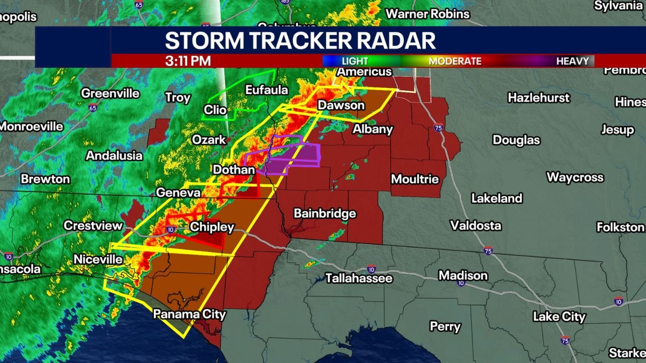
Radar and warning data show a well-organized line of severe storms stretching from the Florida Panhandle into southeast Alabama, continuing into southwest Georgia, where rotation has intensified within several cells.
Confirmed Tornado Activity in Southeast Alabama and Southwest Georgia
According to radar imagery and warning polygons, confirmed tornadoes have been detected in parts of southeast Alabama, with storms tracking directly toward Early County, Georgia.
A confirmed tornado warning was issued for Early County, GA, including areas near:
- Centerville
- Damascus
- Blakely
- Lucile
- Cedar Springs
Storm motion indicates the circulation moving east-northeast, placing additional southwest Georgia communities in immediate danger.
Florida Panhandle Storms Fueling the Outbreak
The strongest storms initially developed across the Florida Panhandle, including areas near:
- Panama City
- Chipley
- Niceville
These storms intensified rapidly as they crossed into southeast Alabama, producing strong wind shear and rotation favorable for tornado development. The Panhandle storms are acting as the energy source, feeding the severe weather farther inland.
High-Risk Radar Signatures and Wind Threat
Velocity scans show tight wind rotation embedded within the line, with storm-relative winds strong enough to support:
- Tornado formation
- Widespread damaging straight-line winds
- Power outages and tree damage
Several radar frames also suggest embedded circulations, meaning tornadoes may develop quickly with little visual warning, especially in rain-wrapped storms.
Immediate Safety Concerns for Affected Areas
Residents in southeast Alabama, southwest Georgia, and the Florida Panhandle are urged to take this outbreak seriously:
- Tornadoes may form with minimal warning
- Storms are moving quickly, reducing reaction time
- Power outages and blocked roads are likely
Anyone in a tornado warning area should be in a sturdy structure, away from windows, and prepared to take shelter immediately.
Why This Setup Is Dangerous
This outbreak is being driven by:
- Strong low-level wind shear
- A mature squall line with embedded supercells
- Warm, unstable air feeding storms from the Gulf
These ingredients are classic for Southeast winter tornado events, which often occur in fast-moving, rain-wrapped storms that are difficult to visually detect.
What to Expect Next
As the storm line continues east and northeast:
- Additional tornado warnings are likely
- Severe storms may expand deeper into southwest and south-central Georgia
- Wind damage could continue even outside tornado paths
This remains a rapidly evolving situation.
Stay alert and keep monitoring updates.
Have you experienced severe weather in your area today? Share what you’re seeing and stay connected with ChicagoMusicGuide.com for continued national weather coverage and real-time updates as this outbreak unfolds.