New England, New York, New Jersey, Pennsylvania, Maryland, Delaware, and Virginia Face Uncertain Nor’easter Threat as Weekend Coastal Storm Scenarios Emerge
UNITED STATES — Forecast models are increasingly signaling the potential for another significant coastal storm along the East Coast this coming weekend, but meteorologists caution that uncertainty remains high regarding the storm’s final track, strength, and impacts. While some guidance supports a classic nor’easter setup, others keep the system farther offshore, reducing impacts for major population centers.
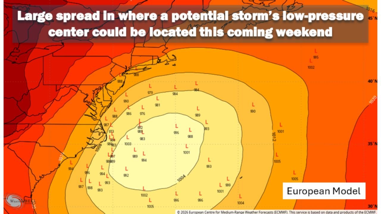
What the Forecast Models Are Showing Right Now
Recent runs of the European (ECMWF), GFS, and Canadian models suggest a disturbance developing in the northern Gulf of Mexico, tracking across Florida before emerging into the western Atlantic. From there, the system may strengthen rapidly as it moves northward along the coastline — a process known as bombogenesis, where surface pressure drops by 24 millibars or more in 24 hours.
If this rapid intensification occurs close enough to land, it would favor heavy snow, strong winds, and coastal flooding across parts of New Jersey, New York, Connecticut, Rhode Island, Massachusetts, and Maine, with possible spillover impacts into Pennsylvania, Maryland, Delaware, and Virginia. However, even modest shifts in the storm’s track could dramatically change who sees snow versus who sees little more than gusty winds.
Three Primary Scenarios Meteorologists Are Watching
Forecast discussions currently outline three main outcome paths for this potential nor’easter:
Scenario A: The storm tracks near the critical 40°N / 70°W benchmark, delivering a high-impact winter storm with heavy snow, damaging winds, and coastal flooding for southern and eastern New England and portions of the Mid-Atlantic.
Scenario B: The system stays slightly offshore, grazing the coast with fringe snowfall, breezy conditions, and above-normal tides, but avoiding widespread disruption.
Scenario C: The storm tracks well south and east, remaining mostly over open water and missing the coast entirely.
Current probability estimates lean toward Scenario A or B, with Scenario C considered least likely, though confidence remains limited at this lead time.
Why This Storm Could Be Different From the Last One
Unlike the recent winter system that produced widespread inland impacts, this setup resembles a more traditional nor’easter, where the strongest effects focus near the coastline. With cold air already in place, any precipitation that reaches inland areas would likely fall as snow, increasing the risk of blizzard-like conditions if strong winds align with heavy snowfall rates.
Another complicating factor is the full moon, which coincides with higher astronomical tides. Even a moderate-strength storm could lead to coastal flooding and shoreline erosion, especially in vulnerable areas of New Jersey, Long Island, and coastal New England.
Timing and What to Watch Next
Based on current data, the most likely window for impacts would be Saturday night into Sunday, though this timeline may shift as new model runs arrive. Ensemble guidance shows a large spread in where the storm’s low-pressure center could track, highlighting just how sensitive the forecast remains.
Forecasters emphasize that now is not the time to panic or change plans, but it is the time to stay informed. Small atmospheric adjustments over the next several days will determine whether this becomes a major winter storm or a near miss.
As confidence improves, clearer guidance on snowfall totals, wind potential, and coastal impacts will emerge.
For continued updates on evolving weather threats, regional impacts, and forecast analysis, stay connected with ChicagoMusicGuide.com, where we track major systems affecting travel, events, and communities across the country.