Virginia, Maryland, West Virginia, Pennsylvania, Ohio, and New York Brace for Dangerous Arctic Cold and Possible Winter Storm Into Early February
UNITED STATES — A powerful blast of Arctic air is tightening its grip on the eastern half of the country, bringing dangerously cold temperatures, life-threatening wind chills, and the potential for another winter storm across the Mid-Atlantic, Ohio Valley, and Northeast states as January comes to an end and February begins.
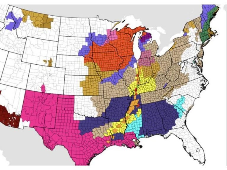
Forecast guidance from the National Weather Service shows persistently below-freezing conditions stretching from the Central Plains through the Great Lakes, Mid-Atlantic, and into New England, with some areas expected to remain below freezing for multiple consecutive days.
Arctic Cold Deepens Across the Eastern U.S.
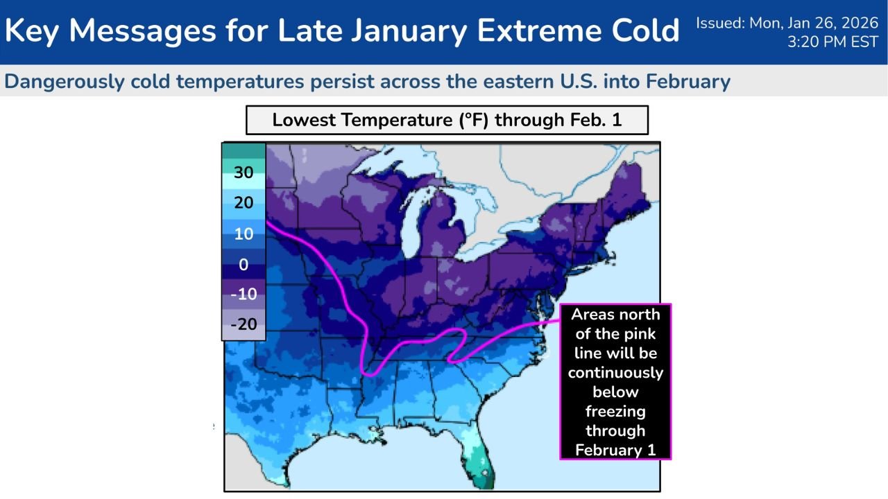
The latest outlook highlights record-challenging cold temperatures across much of the eastern United States, especially north of a boundary stretching from Texas through the Tennessee Valley and into the Carolinas.
Temperatures are expected to plunge into the single digits and below zero across portions of the Upper Midwest, Ohio Valley, interior Mid-Atlantic, and Northeast, while wind chills could drop into the -10° to -20° range in some areas.
This prolonged cold increases the risk of hypothermia, frostbite, frozen pipes, and power-related disruptions, particularly in communities still recovering from recent winter storms.
Mid-Atlantic and I-95 Corridor Under Monitoring
New Day 6 and Day 7 Winter Storm Threat outlooks place much of the Mid-Atlantic region — including Maryland, Virginia, West Virginia, and southern Pennsylvania — under a broad zone of potential winter weather impacts from late Saturday into early next week.
Areas of concern include:
- Washington, D.C. metro area
- Baltimore and central Maryland
- Northern and central Virginia
- Eastern West Virginia
- Southern Pennsylvania
At this stage, confidence remains low on exact placement, but the pattern supports the possibility of snow, mixed precipitation, or rain changing to snow, depending on how the storm system develops offshore.
Why Forecast Confidence Is Still Limited
Weather models show a wide range of possible storm tracks, especially for the developing low-pressure system expected to form near or off the East Coast.
Small shifts in the storm’s track could mean:
- Significant snowfall for coastal or inland areas, or
- A near miss with minimal accumulation, especially along the I-95 corridor
Forecasters emphasize that it is too early to panic or change plans, but conditions will need to be monitored closely as higher-confidence data becomes available later in the week.
Cold Air Lingers Into Early February
Beyond the storm threat, the cold itself is expected to persist into early February, with many locations across the eastern U.S. staying well below normal temperatures even after precipitation chances pass.
Maps indicate that areas north of the highlighted boundary line will remain continuously below freezing through at least February 1, prolonging cold-related risks and infrastructure strain.
What Residents Should Do Now
While details are still evolving, residents across affected states should:
- Limit prolonged outdoor exposure
- Protect pets, plants, and exposed pipes
- Monitor local forecasts daily
- Prepare for potential travel disruptions this weekend
Final Word
The pattern supports dangerous cold first, followed by a possible winter storm, especially across the Mid-Atlantic, Ohio Valley, and Northeast states. Forecast confidence will improve in the coming days, but this is a setup that demands attention, not panic.
Stay weather-aware and check back with ChicagoMusicGuide.com for updated forecasts, refined timelines, and impact details as new data comes in.