Georgia Ice Storm Verified: NWS Atlanta Forecast Matches Actual Ice Totals Across North and Central Georgia
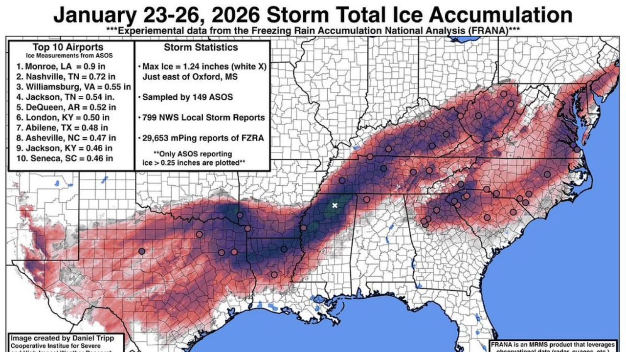
GEORGIA — As cleanup continues across parts of the Southeast, newly released comparison maps confirm that the National Weather Service office in Atlanta accurately forecast the footprint and intensity of the January 23–26, 2026 ice storm across much of Georgia, closely matching what ultimately fell on the ground.
Side-by-side graphics comparing pre-event forecasts with observed ice accumulation show a near-match in both placement and severity, particularly across north and central Georgia, where freezing rain caused hazardous travel, tree damage, and prolonged recovery efforts.
Meteorologists had flagged this system as a cold air damming (CAD)–driven ice event, and post-storm analysis confirms that the setup behaved almost exactly as expected.
Forecast vs. Reality: Ice Footprint Nearly Identical
Before the storm began, NWS Atlanta projected a swath of moderate to significant ice stretching from northwest Georgia through metro Atlanta and into northeast Georgia.
Observed accumulation maps now show that same corridor receiving 0.30 to 0.80 inches of ice, with the heaviest totals aligning closely with the original forecast zone.
Key verified totals include:
- North Georgia (Gainesville, Jasper, Blairsville): Up to 0.80 inches
- Metro Atlanta: Around 0.35 inches
- Athens area: Near 0.50 inches
- Southern fringe (Griffin, Sandersville): 0.05–0.15 inches, matching forecast tapering
The sharp southern cutoff — a common challenge in ice forecasting — was also well captured, limiting over-forecasting farther south.
Why This Forecast Was So Accurate
Ice storms are among the hardest weather events to predict, requiring precise alignment of:
- Sub-freezing surface temperatures
- Warm air aloft
- Continuous moisture supply
In this case, cold air damming held firm longer than usual, allowing freezing rain to persist across interior Georgia while warmer air remained trapped above the surface.
The NWS Atlanta forecast successfully:
- Identified the CAD wedge
- Correctly placed the heaviest icing axis
- Avoided over-extending impacts into southern Georgia
Meteorologists later noted that even small temperature errors could have dramatically changed outcomes — making the verification especially notable.
How This Storm Compared to Past Georgia Ice Events
While not the most destructive ice storm on record, this event stands out for its:
- Geographic precision
- Widespread moderate icing
- Long-duration freezing rain
In several locations, ice totals ranked among the highest seen in years, reinforcing how rare and dangerous these setups can be in Georgia’s climate.
What Comes Next
Officials are still finalizing county-level ice reports, which will provide additional detail on:
- Localized damage patterns
- Tree and infrastructure impacts
- Micro-scale temperature variations
Those final datasets will further validate just how closely the forecast matched reality.
Bottom Line
The January 2026 Georgia ice storm now stands as a textbook example of high-confidence winter weather forecasting, with NWS Atlanta’s pre-event outlook aligning closely with what actually occurred — an achievement rarely seen with freezing rain events.
Winter weather analysis, storm verification, and regional impact breakdowns will continue here.
Follow ChicagoMusicGuide.com for expert-driven weather coverage, forecast explainers, and real-time updates as the season unfolds.