Illinois, Indiana, Ohio, Michigan, Pennsylvania, New York, and Florida Stare Down Potentially Historic Arctic Cold Through Early February
UNITED STATES — A dangerous and unusually long stretch of extreme cold is tightening its grip across the eastern half of the country, with forecasters warning that some regions may be experiencing their longest sustained cold spell in decades. New analysis from the National Weather Service shows brutally cold air persisting through late January and into early February, with multiple Arctic surges reinforcing the freeze.
Temperatures across large parts of the Midwest, Great Lakes, Ohio Valley, and Northeast are expected to remain well below seasonal averages, while wind chills in several states will continue to plunge into life-threatening territory.
Bitter Cold Persists Through Midweek Across the Midwest and Northeast
Forecast data indicates continued extreme cold through midweek, particularly from Illinois and Indiana through Ohio, Michigan, Pennsylvania, and New York. Overnight lows are expected to fall sharply, with wind chills ranging from -15°F to -20°F, especially during nighttime and early morning hours.
While some limited daytime moderation is possible farther south in portions of Tennessee, Mississippi, and Louisiana, this brief relief will not be enough to offset the overall cold pattern dominating the eastern United States.
Meteorologists caution that even short periods outdoors can become dangerous, especially in areas experiencing persistent sub-zero wind chills.
Next Arctic Surge Set to Reinforce the Cold Late Week
Another powerful Arctic air mass is expected to surge southward beginning Friday, pushing through the Plains, Great Lakes, Ohio Valley, and Southeast. This new wave of cold air is likely to drive temperatures even lower, with daily record lows possible across parts of the Midwest and Mid-Atlantic.
By the weekend, the cold will expand farther south and east, with Florida and Gulf Coast agricultural areas also facing the risk of hard freezes. Officials warn that sensitive crops, exposed pipes, and outdoor infrastructure could be impacted if protective measures are not taken.
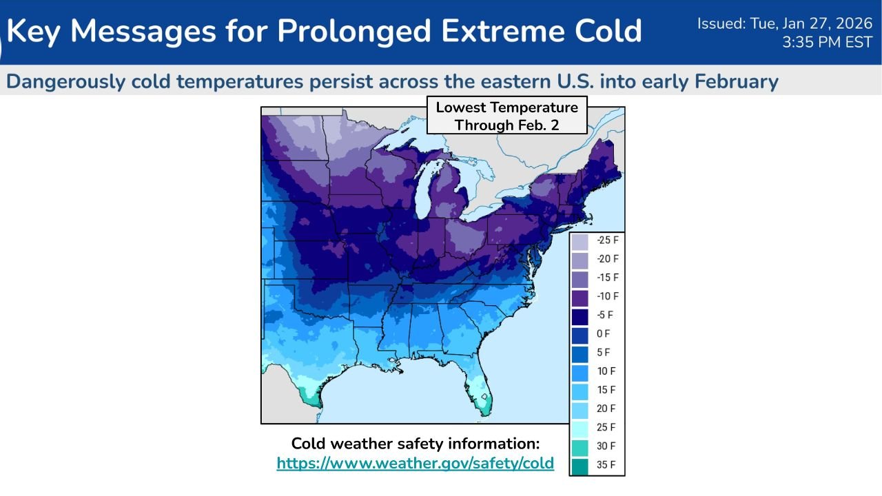
Lowest Temperatures Expected to Hold Through Early February
Temperature outlook maps show that below-normal readings may persist through February 2, suggesting this cold outbreak is not a short-lived event. Northern states are expected to remain locked in deep cold, while southern regions experience repeated intrusions of freezing air.
Forecasters emphasize that the duration of this cold pattern is what makes it particularly dangerous, increasing cumulative stress on infrastructure, energy systems, and public health.
Cold Weather Safety Remains Critical
With this prolonged freeze, officials continue to stress cold weather safety. Frostbite can occur in as little as 15–30 minutes on exposed skin when wind chills drop below zero. Residents are urged to dress in layers, cover exposed skin, limit time outdoors, and ensure pets and livestock are protected.
Homeowners are also advised to take precautions against frozen pipes, especially in regions not accustomed to extended sub-freezing conditions.
As this historic cold pattern continues to unfold, stay alert for updated warnings and advisories as conditions evolve.
For ongoing national and regional weather coverage, stay connected with ChicagoMusicGuide.com, where we track major weather events impacting communities across the country.