South Carolina, Georgia, North Carolina, and Florida Could See Rare Snow as Arctic Cold and Coastal Storm Collide This Weekend
UNITED STATES — A rare and potentially disruptive winter weather setup is taking shape across South Carolina, Georgia, North Carolina, and Florida, as deep Arctic cold already in place interacts with a developing coastal storm system expected to approach the Southeast this weekend. Forecast models suggest the system could produce snowfall in areas unaccustomed to winter weather, with the greatest uncertainty centered on the storm’s exact track and intensity.
Deep Arctic Cold Creates a High-Risk Setup
The eastern United States remains locked in a prolonged Arctic air mass, with temperatures well below normal across the Southeast. This cold is unusually deep and persistent for late January, creating an environment where even a modest coastal storm could generate wintry precipitation far south of typical snow zones.
For much of Georgia, South Carolina, and North Carolina, surface and upper-level temperatures appear cold enough to support snow if moisture moves inland. In Florida, especially the Panhandle and far northern sections, temperatures may briefly support snow showers or flurries during the coldest part of the event.
Meteorologists emphasize that the cold air is the “non-negotiable” part of this forecast — it is firmly established and will not retreat before the weekend.
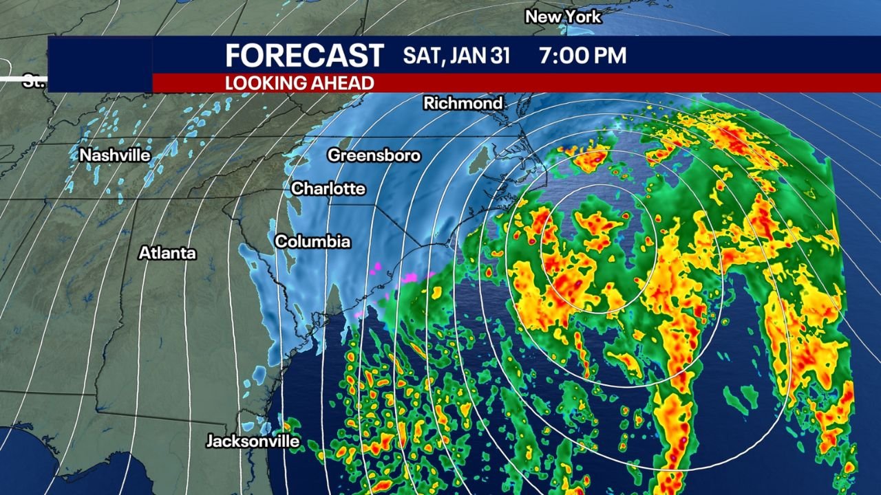
Coastal Storm Track Will Decide Who Sees Snow
Forecast confidence hinges on the track of a developing low-pressure system offshore of the Southeast coast. Early guidance, including high-resolution modeling, suggests a scenario where moisture wraps back toward the coastline as the storm intensifies offshore.
If the system tracks slightly closer to the coast, snow totals could increase sharply, particularly across South Carolina and southern North Carolina. A farther-offshore track would limit impacts, keeping most precipitation offshore with only scattered flurries inland.
This narrow margin is why forecasters describe the setup as “tricky” — small changes in storm position could produce dramatically different outcomes across short distances.
Snow Potential by Region
For South Carolina and North Carolina, the current signal favors the highest snowfall potential, especially inland from the coast where cold air is deepest and most consistent. Cities such as Charleston, Columbia, Charlotte, and Raleigh sit close enough to the storm’s potential influence zone to warrant close monitoring.
In coastal Georgia, minor snow accumulation is possible if moisture pushes inland early Saturday. Areas around Savannah may see brief snow or a rain-snow mix, particularly during the coldest hours.
For Florida, impacts are expected to be more limited. Forecast guidance supports snow showers or flurries in the Florida Panhandle early Saturday morning, with a small chance of wraparound flurries reaching toward the Jacksonville area by Saturday evening. Any accumulation in Florida would likely be minimal and short-lived.
Critical Timing: Saturday Morning Through Saturday Night
The primary window for winter weather impacts appears to run from early Saturday morning through Saturday night, depending on storm evolution. Snow or flurries could begin quickly if moisture arrives while temperatures remain at their coldest.
Travel impacts, even from light snow, could be significant due to lack of treatment resources, especially on bridges and elevated roadways. Power infrastructure may also be stressed by the combination of cold temperatures and precipitation.
By late Saturday night, the storm is expected to pull farther offshore, though lingering flurries could persist in parts of the Carolinas.
Uncertainty Remains High, but Impacts Could Be Outsized
Forecasters continue to stress that confidence in exact snowfall totals remains low, particularly outside the Carolinas. However, the risk is not being dismissed because southern snow events often cause disproportionate disruptions, even with minimal accumulation.
The combination of historic cold, unfamiliar winter precipitation, and weekend travel makes this a situation worth preparing for — even if the final outcome trends lighter.
Residents across South Carolina, Georgia, North Carolina, and Florida are encouraged to remain alert, monitor forecast updates closely, and prepare for rapidly changing conditions.
As this rare winter weather threat evolves across the Southeast, staying informed is critical. For continued updates on this developing storm, regional impacts, and winter safety coverage, visit ChicagoMusicGuide.com.