North Carolina, Virginia, South Carolina, and West Virginia Face Potential Heavy Snow as East Coast Storm Tracks Closer to Mid-Atlantic
UNITED STATES — A strengthening winter storm system is taking shape across the eastern United States, with new National Weather Service snowfall guidance showing a broad swath of accumulating snow developing across North Carolina, Virginia, West Virginia, and South Carolina through late Saturday and into Sunday. While confidence continues to evolve, the latest 72-hour snowfall projections indicate the highest accumulation potential centered across the central and western Carolinas and into southern Virginia, with additional impacts extending into the southern Appalachians.
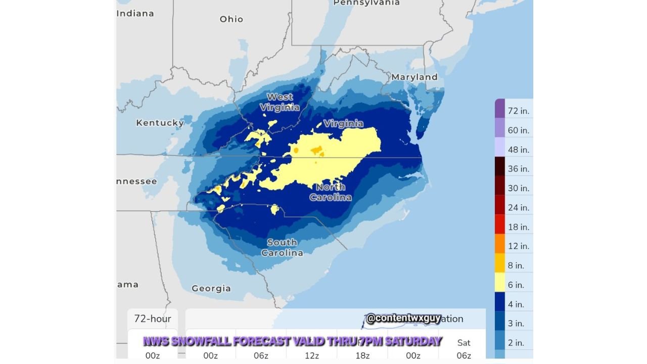
Forecast data released Wednesday shows snowfall totals now populated through 0z Sunday, with additional refinement expected for the upper Mid-Atlantic and southern New England in the next model cycle.
Snowfall Potential Expands Across the Carolinas and Virginia
According to the latest snowfall forecast, North Carolina currently sits at the core of the projected snow shield. Much of central and western North Carolina is shaded in the 6–10 inch range, with localized higher totals possible in elevated terrain. Surrounding areas of Virginia and West Virginia are also showing widespread 3–6 inch totals, particularly across the Blue Ridge and Appalachian regions.
Parts of South Carolina, especially northern sections closer to the North Carolina border, are included in the lower accumulation zone, where lighter but still impactful snow remains possible.
While these totals remain preliminary, the expanding coverage signals increasing confidence that this system will produce meaningful winter weather impacts across a large portion of the Southeast and southern Mid-Atlantic.
Storm Track and Timing Remain Critical
Meteorologists continue to monitor subtle shifts in the storm’s track, which will ultimately determine how far north and east heavier snow extends. At this stage, guidance suggests the system will strengthen as it moves east-northeast, allowing colder air to remain entrenched across the interior Southeast.
Snow is expected to develop late Saturday, intensifying overnight and continuing into Sunday, particularly across the Carolinas and Virginia. Any eastward or westward adjustment in the storm’s center could significantly alter snowfall totals, especially near coastal and transition zones.
Appalachian Terrain Could See Locally Higher Totals
The highest confidence for accumulating snow currently lies across higher elevations of western North Carolina, southwest Virginia, and parts of West Virginia. Orographic lift combined with colder air aloft may enhance snowfall rates in these areas, pushing localized totals above surrounding lowland regions.
Travel through mountain passes and elevated roadways could become hazardous as snow accumulates, especially during overnight hours when temperatures remain cold enough to prevent melting.
What Comes Next
Additional snowfall guidance for Maryland, the upper Mid-Atlantic, and southern New England is expected to be released Thursday night as the system enters a higher-confidence window. Until then, forecasters stress that totals and impact zones remain subject to change.
Residents across North Carolina, Virginia, South Carolina, and West Virginia are encouraged to monitor updated forecasts closely, especially if travel plans are scheduled for the weekend.
Stay with ChicagoMusicGuide.com for continued updates as new data becomes available and the storm’s final track comes into focus.