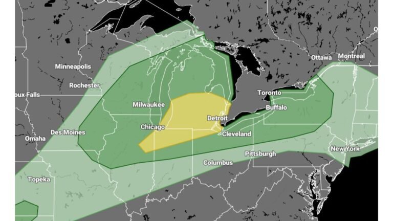
Northeast Illinois and Northwest Indiana Brace for Heavy Lake-Effect Snow Waves Friday Through Saturday With Travel Impacts Likely
ILLINOIS — A prolonged lake-effect snow event is expected to impact northeast Illinois and northwest Indiana from Friday into Saturday, with snow falling in multiple waves and occasionally becoming very heavy, especially near Lake Michigan. Forecast data indicates 2 to 8 inches of accumulation is possible in favored locations, with localized higher totals where persistent snow bands develop.
Meteorologists say this will not be a single, steady snowfall, but rather a band-driven lake-effect setup, meaning conditions can change rapidly from one community to the next.
Lake-Effect Snow Will Arrive in Distinct Waves
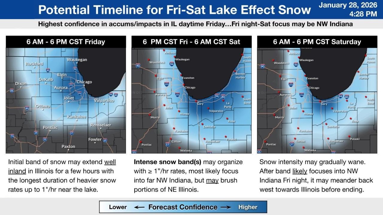
According to the latest forecast guidance, the highest confidence for impactful snowfall begins Friday morning and continues into Friday night, with additional snow lingering into Saturday as lake-effect bands shift.
- Friday daytime: Initial snow bands may extend well inland across northeast Illinois, bringing bursts of moderate to heavy snow near the lake with snowfall rates approaching 1 inch per hour at times.
- Friday night: The most intense phase is expected, with organized snow bands likely focusing over northwest Indiana, though portions of far northeast Illinois may still be affected depending on band placement.
- Saturday: Snow intensity may gradually weaken, but lingering bands could meander back toward Illinois before finally tapering off.
Because lake-effect snow is highly localized, some areas may see only light accumulations, while nearby communities experience several inches in a short time.
Chicago Area and Northwest Indiana Face the Greatest Travel Risk
Communities most at risk include lake-adjacent areas of Cook County, Lake County (IL), and Lake, Porter, and LaPorte counties in Indiana. Snowfall rates during peak banding could quickly reduce visibility and create slick, snow-covered roads, especially on east-west routes.
Drivers should be prepared for:
- Rapidly changing road conditions
- Poor visibility during heavier snow bursts
- Slower commute times Friday and Saturday
Even inland suburbs may see brief periods of heavier snow as bands shift westward.
Why This Setup Is Concerning
Lake-effect snow events are notoriously difficult to pin down because small changes in wind direction can dramatically alter where snow bands set up. Forecast confidence is moderate, but impacts could increase quickly if bands stall over the same locations for several hours.
Forecasters emphasize that snow totals may vary sharply over short distances, making this a situation that requires close monitoring, especially for those traveling near the lake.
What Residents Should Expect Next
Snow showers may persist in weaker form into Saturday afternoon, with overall improvement expected later in the day as lake-effect activity diminishes. However, slick roads and residual impacts could linger even after snowfall tapers.
Residents are encouraged to stay alert for updated forecasts and advisories as the event unfolds.
For continued updates on this developing lake-effect snow event and other Midwest weather impacts, keep following ChicagoMusicGuide.com.