Alabama, Mississippi, Tennessee, Georgia and Kentucky Could See Clearer Severe Weather Warnings as SPC Rolls Out Major Outlook Changes
UNITED STATES — The Storm Prediction Center (SPC) is preparing to implement one of its most significant updates in years to how severe weather risk is displayed, with major changes expected to take effect on or around March 2. The revisions will impact SPC’s Convective Outlook maps used nationwide to communicate tornado, wind, and hail threats.
According to early guidance, the updates are designed to provide greater clarity on the intensity and confidence of severe weather hazards, particularly during high-end outbreaks. Meteorologists say the changes will not increase or decrease actual risk, but will help the public and emergency managers better interpret what those risks mean.
What Changes Are Coming to SPC Convective Outlooks
The most notable update is the introduction of three distinct types of hatching to represent escalating levels of significant severe weather. Previously, hatched areas were used more broadly to highlight enhanced risk zones, but the new system will differentiate intensity tiers rather than grouping all significant threats together.
Each hatching style will correspond to increasing severity, allowing forecasters to visually separate moderate significant events from high-end, potentially historic outbreaks.
New Wind Probability Contours Will Be Added
Another major shift involves expanded wind probability thresholds. SPC will begin issuing 75% and 90% wind probability contours, a move that reflects improvements in forecasting confidence during extreme wind events such as derechos and widespread severe wind outbreaks.
Until now, lower probability contours often made it difficult to distinguish between isolated severe wind potential and truly widespread damaging wind scenarios. The higher thresholds aim to reduce confusion and better communicate when destructive winds are likely across large regions.
How the New Outlooks Compare to the Old System
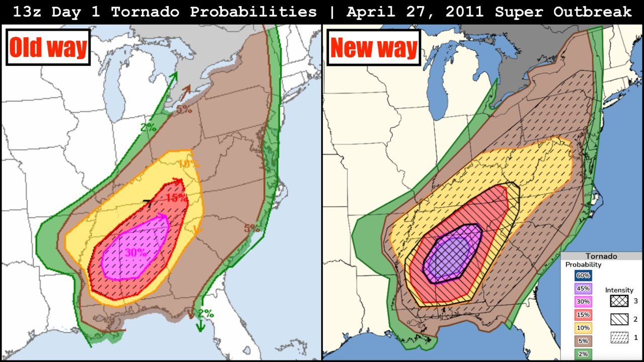
A comparison using historic outbreaks, including the April 27, 2011 Super Outbreak, shows how the updated graphics would have emphasized the most dangerous zones more clearly. Under the old method, very large areas could appear equally threatening, even though the most intense tornado potential was concentrated in smaller regions.
The revised outlooks focus on precision rather than expansion, helping viewers understand where the greatest risk truly exists, not just where storms are possible.
Why These Changes Matter for the Public
SPC officials emphasize that these updates are about communication, not altering forecast philosophy. By clearly showing when hazards are both likely and intense, the new outlooks may help improve response times, preparedness decisions, and public understanding during severe weather days.
This is especially important during fast-evolving outbreaks when minutes matter and messaging clarity can directly impact safety outcomes.
What to Expect Going Forward
As the new outlooks are rolled out this spring, meteorologists expect a short learning curve for the public. Forecasters encourage weather consumers to focus less on color alone and more on probability percentages and hatching meaning when assessing risk.
Educational efforts are expected to accompany the rollout, including explainer graphics and videos showing how to interpret the new format.
What This Means for Severe Weather Season
With severe weather season approaching across much of the U.S., the timing of the update is intentional. SPC officials say the changes will allow forecasts to better reflect confidence levels during high-impact events, particularly when long-track tornadoes or widespread destructive winds are possible.
The bottom line: risk communication is getting sharper, not scarier.
If you want continued breakdowns of major weather system changes, storm trends, and forecast interpretation as we move deeper into severe weather season, stay connected with ChicagoMusicGuide.com, where we track the science behind the headlines.