Alabama Braces for Bitter Arctic Cold, Scattered Snow Showers, and Dangerous Wind Gusts Through Saturday
ALABAMA — A surge of very cold Arctic air is settling into the state tonight, bringing freezing temperatures, scattered snow showers, and strong north winds that will persist through Saturday, according to updated forecasts from the Alabama Weather Network and the National Weather Service.
Forecasters say tonight into Saturday morning will be the coldest stretch of the ongoing cold wave, with much of Alabama struggling to warm significantly even during daylight hours.
Coldest Temperatures of the Event Arrive Overnight
Temperatures across north and central Alabama are expected to remain in the 20s on Saturday, with some locations failing to rise above freezing at all.
Even southern Alabama, including Mobile and Dothan, will have difficulty climbing above 32°F, an unusually cold setup for the region. Overnight lows will dip into the teens and lower 20s, especially north of Interstate 20.
Wind chills will make conditions feel even colder.
Wind Chills Drop Into the Single Digits and Below Zero
Strong north winds will increase behind the Arctic front, producing dangerously low wind chills early Saturday.
Forecast maps show wind chills dropping to:
- Single digits across much of central Alabama
- Below zero at times in northern counties
This combination of cold temperatures and wind poses a risk for frostbite and hypothermia, particularly for anyone outdoors for extended periods.
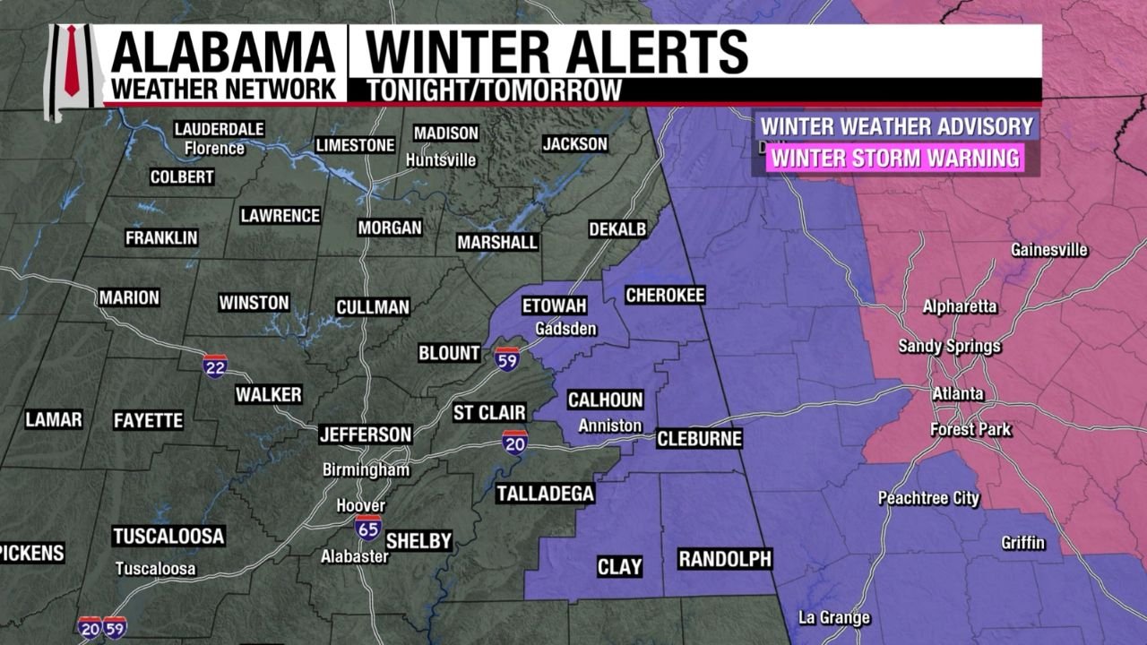
Scattered Snow Showers Possible, Especially in East Alabama
Light snow showers are expected to develop late tonight and continue into Saturday morning as colder air deepens across the state.
The highest coverage is expected across northeast and east Alabama, where a Winter Weather Advisory is in effect for six counties. In these areas:
- Up to 1 inch of snow is possible in isolated spots
- Brief heavier snow showers could reduce visibility
- Icy patches may develop on untreated roads and bridges
Elsewhere, snow amounts will be lighter and more scattered, but even minor snowfall could cause slick travel conditions.
Wind Gusts Reach 30–40 MPH Statewide
An icy north wind will be a major factor Saturday, with gusts between 30 and 40 mph expected across much of Alabama.
These winds will:
- Exacerbate already dangerous wind chills
- Make driving difficult for high-profile vehicles
- Increase the risk of downed tree limbs where soils are saturated
A Wind Advisory remains in effect for large portions of the state.
Travel and Safety Concerns Through Saturday
Residents are urged to use caution, especially during the early morning hours Saturday when temperatures and wind chills will be at their lowest.
Key safety concerns include:
- Slick roads where snow showers develop
- Rapid heat loss due to strong winds
- Increased risk for pets, livestock, and exposed pipes
Forecasters stress that conditions will remain cold beyond the weekend, even as the snow threat diminishes.
What Happens Next
While snowfall chances trend downward after Saturday morning, cold conditions will persist into next week, with only gradual moderation expected.
Another round of Arctic air later next week remains possible, keeping temperatures below normal for several more days.
Have you seen snow or icy conditions where you live in Alabama? Share your local weather reports and stay updated with ongoing regional coverage at ChicagoMusicGuide.com.