Florida Cold Outbreak Brings Rare Snow Chance to Tampa as Gulf-Effect Showers Target West-Central Counties Sunday Morning
TAMPA, FLORIDA — An exceptionally cold Arctic air mass moving into Florida is creating a rare and historic setup that could allow snowflakes to fall in the Tampa metro area early Sunday morning, something that happens only once or twice in a century. Forecast guidance now suggests someone in the Tampa area is likely to see snowflakes, with a nonzero chance of measurable snowfall at Tampa International Airport if conditions align perfectly.
Why Snow Is Suddenly on the Table for Tampa
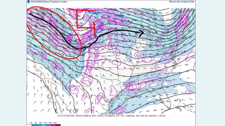
Meteorologists say the setup is driven by the coldest air mass to reach Florida since 2018, plunging southward behind a powerful winter system. As this frigid air passes over the warmer waters of the Gulf of Mexico, moisture is lifted upward, creating ocean-effect (or “Gulf-effect”) snow showers—a phenomenon more common near the Great Lakes than the Florida coastline.
High-resolution guidance from the NAM 3km model indicates snow showers may develop overnight and move onshore during the early Sunday morning hours, placing the Tampa Bay region directly in the potential impact zone.
Historic Context: How Rare This Event Could Be
If Tampa International Airport records at least 0.1 inch of snow, it would mark the city’s first measurable snowfall since 1977. Even more remarkable, Tampa has only one documented measurable snowfall on record—0.2 inches on February 13, 1899.
Forecasters note that if the airport were to reach 0.2 inches, Tampa would officially log its snowiest day in recorded history, underscoring just how extraordinary this setup is.
Model Guidance Shows Low-Probability but High-Impact Potential
While the HRRR model shows only a remote chance of a brief snow squall, meteorologists stress that even seeing this signal at all highlights the rarity of the environment. Although the HRRR solution may be overly aggressive, it supports the broader idea that short-lived, intense snow bursts cannot be ruled out.
These snow showers would be fast-moving and highly localized, meaning some neighborhoods could see snowflakes while others see nothing more than flurries or cold rain.
Counties Most Likely to See Snow Showers
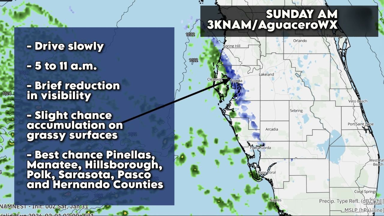
Forecast guidance suggests the best chance of snow showers will occur between 5 a.m. and 11 a.m. Sunday, mainly affecting coastal and near-coastal areas of west-central Florida.
The counties with the highest probability include:
- Pinellas County
- Hillsborough County
- Manatee County
- Polk County
- Sarasota County
- Pasco County
- Hernando County
Forecasters also note a slight chance of light accumulation on grassy or elevated surfaces, especially during heavier bursts.
Travel and Safety Concerns During Snow Showers
Although accumulation would be minimal, officials warn that brief reductions in visibility could occur during heavier snow showers. Drivers are advised to slow down, use low-beam headlights, and remain alert for rapidly changing conditions.
With Florida roads not designed for winter precipitation, even a light dusting or sudden visibility drop could cause unexpected travel hazards, particularly during the early morning hours.
A Once-in-a-Generation Florida Weather Moment
While widespread snow is not expected, meteorologists emphasize that seeing snowflakes in Tampa is itself a significant weather event, driven by an exceptionally rare combination of deep cold air and Gulf moisture.
Residents are encouraged to stay weather-aware Sunday morning, especially along the Tampa Bay coastline, as Florida experiences one of its most unusual cold-weather setups in decades.
For continued coverage of rare weather events, regional forecasts, and breaking updates across the U.S., visit ChicagoMusicGuide.com.