North Carolina Snowstorm Review Shows Forecast Undershot Historic January 31 System That Delivered Up to a Foot of Snow
NORTH CAROLINA — Meteorologists are now looking back at the January 31, 2026 snowstorm that swept across central and western North Carolina, acknowledging that the historic winter system ultimately delivered significantly higher snowfall totals than originally forecast in several communities. The post-storm analysis highlights just how difficult the event was to predict, especially given that the region had not experienced a comparable storm in more than two decades.
Forecasters say the rarity of the setup, combined with rapidly intensifying snow bands, made this storm one of the most challenging winter events in recent memory.
Why the Initial Snow Forecast Was Conservative
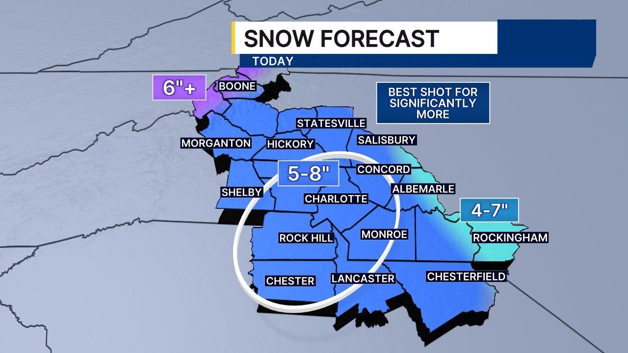
Early forecasts for the storm leaned cautious, with most of the Charlotte metro and surrounding Piedmont counties placed in a 5–8 inch snowfall range. This approach reflected uncertainty tied to storm track, mesoscale banding, and the region’s long absence from major snow events of this magnitude.
Forecasters later nudged totals upward as confidence increased that some areas could see significantly more snow, particularly if narrow but intense snow bands developed and stalled.
What Actually Fell: Snow Totals Far Exceeded Expectations
When snowfall reports were finalized, it became clear that several parts of North Carolina saw totals well above forecast ranges. Verified snowfall data from January 31 shows:
- Statesville and parts of Iredell County: 12 inches or more
- Concord, Albemarle, and surrounding areas: 8–12 inches
- Rock Hill and southern Piedmont locations: 6–8 inches
- Chester County areas: 4–6 inches
These totals confirmed that the storm’s most intense snowfall axis shifted slightly north and intensified more than expected, allowing snow to accumulate at extraordinary rates.
Snow Banding Played a Critical Role
Meteorologists point to persistent mesoscale snow banding as the primary reason snowfall exceeded projections. Once these bands developed, they produced heavy snowfall for several consecutive hours, overwhelming earlier assumptions about accumulation limits.
In some locations, snow fell at rates high enough to quickly surpass conservative forecast ceilings, leading to rapidly deteriorating travel conditions and widespread disruptions.
A Storm Not Seen in Over 20 Years
Experts emphasize that part of the challenge stemmed from the fact that North Carolina has not experienced a storm of this nature in more than 20 years. The atmospheric setup — combining cold air, moisture, and precise storm placement — was highly unusual for the region.
Because historical analogs were limited, forecasting confidence remained lower than with more routine winter systems, reinforcing the cautious approach taken ahead of the event.
What Forecasters Take Away From This Storm
The January 31 snowstorm is already being studied as a benchmark event for future winter forecasting in the Carolinas. Forecasters say it underscores the importance of monitoring late-stage storm evolution and clearly communicating uncertainty when rare, high-impact systems threaten the region.
While forecasts were not dramatically off across the board, the storm demonstrated how quickly conditions can exceed expectations when atmospheric ingredients align just right.
As winter patterns remain active across the Southeast, storms like this serve as a reminder that rare does not mean impossible. For continued winter weather coverage, storm analysis, and regional forecasts, visit ChicagoMusicGuide.com for the latest updates.