Ohio Braces for Snow Tuesday and Friday as Multiple Rounds Bring Slick Roads Across the State
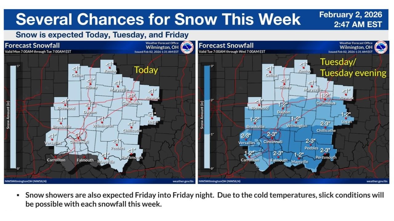
OHIO — With Tuesday now underway, residents across central, southern, and southwestern Ohio are dealing with an active winter pattern, as snow is expected today (Tuesday) and again on Friday, according to the latest forecast issued early February 2, 2026, by the National Weather Service in Wilmington, Ohio. While snowfall amounts are not extreme, cold temperatures and repeated snow chances increase the risk of slick and hazardous travel conditions through the end of the week.
Cities including Columbus, Dayton, Cincinnati, Wilmington, Chillicothe, Portsmouth, and nearby communities are all included in this evolving snow setup.
Snow Develops Today and Intensifies Tuesday Evening
Snow is expected to continue developing through the day Tuesday, with the most impactful period arriving Tuesday afternoon into Tuesday evening. Forecast maps show light snow early, followed by a broader area of accumulating snow later in the day.
Most of central Ohio, including Columbus, Dayton, and Wilmington, can expect around 1–2 inches of snowfall by late Tuesday night. Farther south and southwest — especially near Cincinnati, Falmouth, Peebles, and Portsmouth — totals could reach 2–3 inches, depending on how snow bands set up.
Because temperatures will remain below freezing, snow is expected to accumulate quickly on roads, especially during the evening commute.
Cold Temperatures Mean Snow Will Stick
One of the biggest concerns with today’s snowfall is the lack of melting. With temperatures staying cold, even light snow will stick to untreated roads, bridges, and overpasses.
Forecasters stress that slick conditions may develop rapidly, particularly after sunset. Visibility reductions are also possible during heavier snow bursts, creating additional hazards for drivers traveling Tuesday evening and overnight.
Another Snow Chance Returns Friday Into Friday Night
Ohio will not get a long break after Tuesday’s system. Forecast guidance shows snow showers returning Friday into Friday night, bringing another round of potential accumulation.
While snowfall totals for Friday are still uncertain, officials warn that any additional snow falling on cold surfaces could renew travel issues heading into the weekend. Even minor accumulations may lead to icy and slippery conditions, especially during nighttime hours.
What Ohio Residents Should Expect This Week
Through the end of the week, Ohio residents should prepare for:
- Accumulating snow today (Tuesday), especially by evening
- Slick and icy road conditions
- Reduced visibility during snow showers
- Another round of snow possible Friday
Drivers are urged to slow down, allow extra travel time, and remain alert as conditions change throughout the day.
As Ohio navigates another mid-winter stretch with repeated snowfall chances, staying weather-aware will be critical. For continued updates on Ohio snow forecasts, road conditions, and winter weather impacts, visit ChicagoMusicGuide.com for the latest coverage.