Illinois, Ohio, Pennsylvania, New York, and the Carolinas Lead as Snowy Winter Trend Continues Across the United States
UNITED STATES — The pattern of a snow-heavy winter across major population centers is continuing into early February, with new national snowfall analysis showing that more Americans are experiencing above-average snowfall than below-average this season.
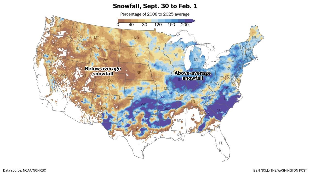
According to nationwide snowfall data covering September 30 through February 1, roughly 52 percent of the U.S. population — about 168 million people — has already seen above-average snowfall, even though only 34 percent of the country’s total land area falls into that same category. The imbalance highlights how densely populated regions across the Midwest, Great Lakes, Northeast, and Southeast have been disproportionately impacted by winter storms so far.
Midwest and Great Lakes: Population Centers Take the Brunt
A broad zone of above-average snowfall stretches from Illinois and Indiana through Ohio, Michigan, and western Pennsylvania, covering several of the nation’s largest metro areas. Cities throughout this corridor have repeatedly landed in active storm tracks, keeping snow totals elevated even during quieter stretches of winter weather.
Chicago and surrounding parts of northern Illinois sit firmly within this above-average zone, reinforcing why the winter has felt especially persistent for residents despite occasional warm-ups.
Northeast Snowfall Runs Well Above Normal
From Pennsylvania through New York, New England, and into Maine, snowfall has significantly exceeded long-term averages. The Northeast has benefited from multiple cold-air intrusions paired with moisture-rich systems, allowing snow events to stack up steadily rather than relying on one or two major storms.
These regions account for a large share of the population contributing to the national 52-percent figure experiencing above-average snowfall.
Southeast Sees a Rare Snowy Stretch
One of the more notable features on the snowfall map is the above-average snowfall extending into the Southeast, including parts of Tennessee, North Carolina, South Carolina, and northern Georgia. While snowfall coverage is patchier than farther north, repeated winter systems have delivered unusual accumulations for the region, boosting seasonal totals above typical values.
This southern snowfall surge plays a key role in explaining why population exposure to snow is outpacing land-area coverage.
Western U.S. Remains Mostly Below Average
In contrast, much of the western United States, including the Pacific Northwest, Great Basin, and central Rockies, continues to show below-average snowfall overall. While localized mountain snowpack exists, widespread lower-elevation snowfall has been limited compared to historical norms.
This west-east split further emphasizes how storm tracks have favored central and eastern states during the first half of winter.
Why This Winter Feels So Snowy
The data reinforces a key takeaway:
Snowfall has been concentrated where people live.
Even though only about one-third of the country’s land area has seen above-average snowfall, repeated storms targeting major metro regions have made winter feel more intense and longer-lasting for millions of Americans.
With February still underway and active patterns continuing, many of these regions may add to their totals before winter loosens its grip.
Want to keep tracking how winter is shaping up across the country? Stay with ChicagoMusicGuide.com for clear, data-driven weather updates all season long.