North Carolina and South Carolina Buried by Weekend Winter Storm as Snow Totals Reach 10–18 Inches in Some Areas
NORTH CAROLINA & SOUTH CAROLINA — A significant winter storm brought widespread snowfall across both Carolinas over the weekend, with National Weather Service snowfall analysis showing several inches to more than a foot of snow in parts of the region. While gradual melting is underway, road conditions remain hazardous in some areas, especially in higher elevations and locations that saw the heaviest totals.
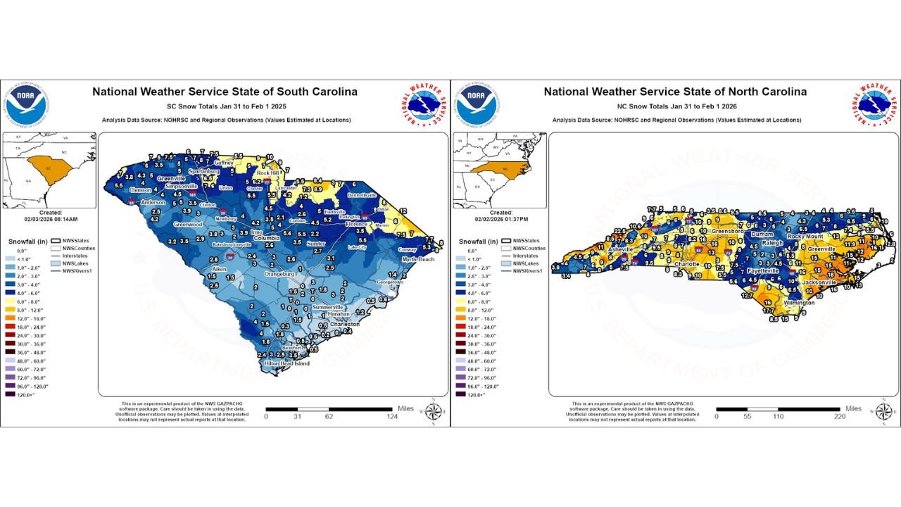
Snow Totals Show Sharp North-to-South Gradient in South Carolina
According to National Weather Service analysis for South Carolina, snowfall totals varied widely across the state.
- Upstate and northern counties saw the highest totals, with many locations reporting 6 to 10 inches of snow.
- Areas around Greenville, Spartanburg, Gaffney, and Rock Hill recorded some of the deepest accumulations, with isolated spots exceeding 10 inches.
- Central South Carolina, including Columbia and surrounding counties, generally received 3 to 5 inches.
- Snowfall tapered off toward the coast, where Charleston, Beaufort, and Hilton Head Island saw light accumulations under 1 inch, with some coastal locations recording only a trace.
This sharp gradient reflects how cold air was deepest across the Upstate while warmer marine air limited snow totals closer to the coastline.
North Carolina Sees Widespread Heavy Snow, Especially Central and Eastern Areas
Snowfall across North Carolina was more uniform and, in many cases, heavier.
- Large portions of the state recorded 6 to 10 inches, including Charlotte, Greensboro, Raleigh, and Fayetteville.
- Eastern counties, including Jacksonville, Wilmington, and Greenville, saw notable totals ranging from 10 to locally 15 inches.
- Parts of southeastern North Carolina reported some of the highest totals in the Carolinas, with isolated amounts approaching 15 to 18 inches.
- Western mountain areas received snow as well, though totals there were generally lower than in the central and eastern parts of the state.
The widespread nature of the snowfall led to significant travel disruptions, particularly on secondary roads and untreated surfaces.
Melting Underway, but Travel Conditions Still Risky
As temperatures rise, snowmelt is occurring across both states, helping improve major roadways. However, officials warn that many secondary roads remain slick, especially in shaded areas and locations where snow was slow to melt.
- Overnight refreezing remains possible in spots.
- Slush and standing water may refreeze after sunset, creating black ice hazards.
- Drivers are urged to use caution, particularly during early morning and late evening hours.
What Comes Next
Forecast trends suggest continued gradual improvement as temperatures climb, though patchy hazards may persist for another day or two in areas that saw the highest snowfall totals.
The weekend storm stands out as one of the more impactful winter events of the season for the Carolinas, delivering snowfall totals more typical of mid-winter systems and leaving lingering effects even as conditions slowly improve.
Stay weather-aware and continue checking local forecasts for updated road and travel conditions. For ongoing winter weather coverage and regional updates, follow ChicagoMusicGuide.com.