Extreme Arctic Cold Targets Illinois, Michigan, New York, Pennsylvania and New England With Dangerous Wind Chills Through Feb. 9
UNITED STATES — A powerful Arctic air mass is set to surge back into the Great Lakes and Northeast beginning late this week, bringing some of the coldest temperatures and wind chills of the season across large portions of the Midwest, Mid-Atlantic, and New England, according to updated early February outlooks issued on February 3–4.
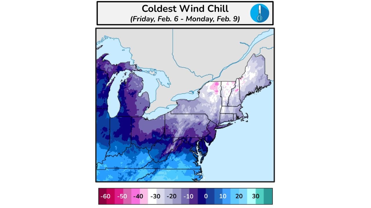
Forecast data shows dangerous wind chills plunging well below zero from Friday, February 6 through Monday, February 9, with the most severe impacts expected across Illinois, Michigan, Ohio, Pennsylvania, New York, Vermont, New Hampshire, and Maine.
Arctic Blast Focuses on the Great Lakes and Northeast
The latest extreme cold guidance highlights a significant Arctic outbreak spreading southeast from Canada into the Great Lakes and Interior Northeast. This surge will reinforce already cold conditions, keeping daytime highs suppressed and nighttime lows dangerously low.
Across much of Illinois, Michigan, Ohio, upstate New York, and northern Pennsylvania, daytime highs may struggle to rise above the teens, with single-digit temperatures possible in colder inland locations. Overnight lows will frequently fall below zero, especially where winds remain elevated.
Wind Chills Drop to Life-Threatening Levels
Wind chill maps valid Friday through Monday indicate widespread sub-zero wind chills, with the coldest readings concentrated across:
- Northern Illinois and the Upper Midwest
- Michigan’s Upper and Lower Peninsulas
- Northern Ohio and western Pennsylvania
- Interior New York and New England
Some locations in the Interior Northeast and New England could experience wind chills in the minus 20s to minus 30s, particularly during overnight and early morning hours. These conditions significantly increase the risk of frostbite and hypothermia with prolonged outdoor exposure.
Gusty Winds and Snow Squall Risk
Along with the bitter cold, gusty northwest winds will continue to funnel Arctic air into the region, enhancing wind chill impacts and creating localized snow squall potential, especially across lake-effect prone areas.
Brief but intense snow squalls are possible in parts of Michigan, Ohio, Pennsylvania, and upstate New York, where rapid visibility reductions and slick road conditions could develop with little warning.
Impacts on Travel, Infrastructure, and Daily Life
The combination of extreme cold and gusty winds may lead to:
- Hazardous travel, especially during overnight and early morning hours
- Strain on heating systems and utilities
- Increased risk of frozen pipes
- Power disruptions where winds combine with lingering snow or ice
Officials urge residents across the affected states to prepare for extended cold exposure, particularly those commuting early, working outdoors, or attending outdoor events.
Cold Weather Safety Remains Critical
Weather guidance emphasizes the importance of cold-weather precautions through the weekend:
- Limit time outdoors during peak cold
- Cover exposed skin to prevent frostbite
- Keep pets and livestock sheltered
- Check on vulnerable neighbors and family members
- Prepare vehicles with emergency winter kits
While a gradual warming trend may begin by the middle of next week, forecasters stress that the upcoming weekend will remain dangerously cold across much of the eastern United States.
As winter’s harsh grip tightens once again, staying informed and prepared will be essential.
For continued weather updates, cold-weather safety coverage, and regional forecasts, keep following ChicagoMusicGuide.com.