ECMWF Snow Map Signals Big Two-Week Snow Run for Washington, Oregon, California, Idaho, Utah and Colorado
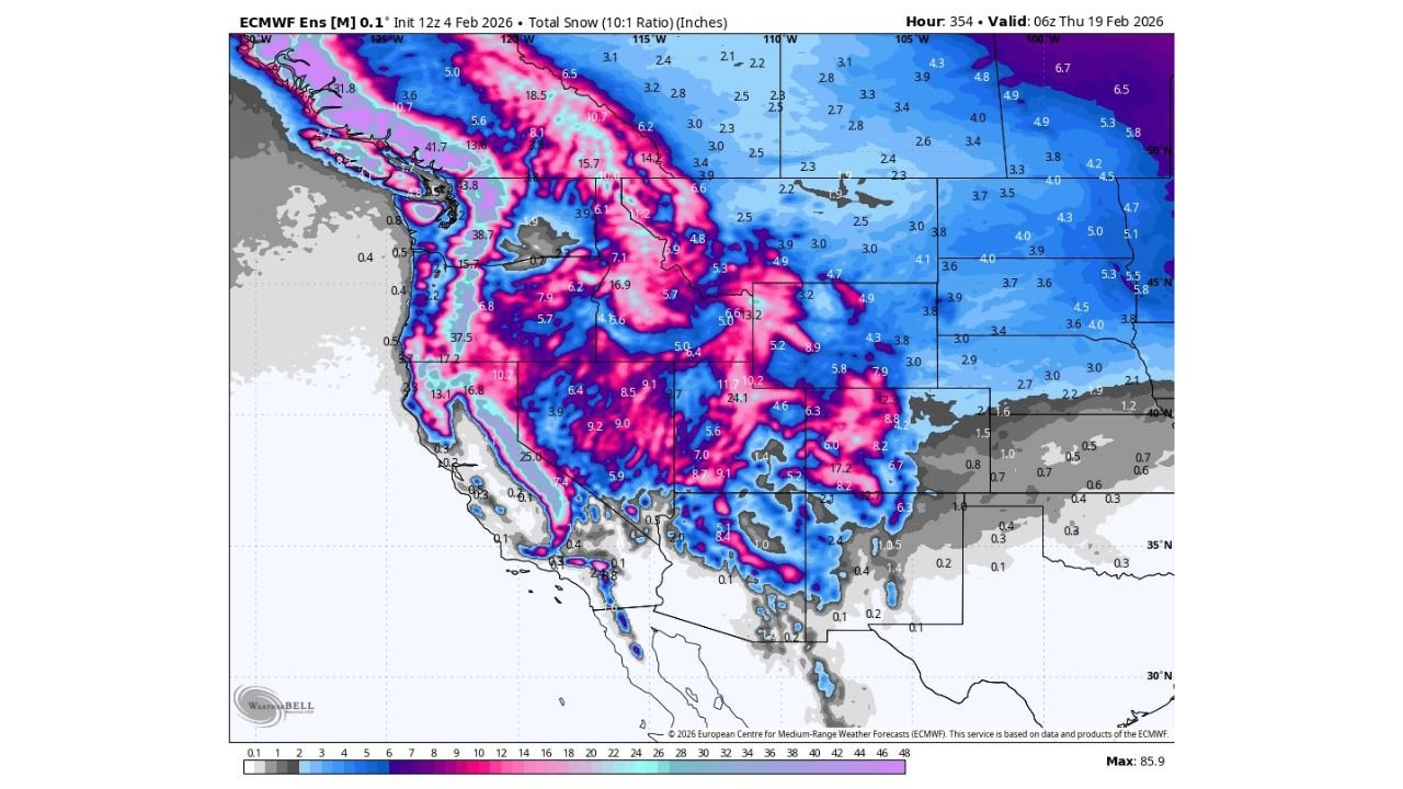
UNITED STATES — A new ECMWF ensemble snowfall outlook is pointing to a strong two-week window for meaningful snow across the Western U.S., with the heaviest totals focused on the Pacific Northwest, the Sierra Nevada, and the Rockies through Thursday, February 19, 2026. The map highlights widespread areas seeing several inches, while high-elevation zones in multiple states show the potential for multi-foot accumulations during this stretch.
What the ECMWF Snow Outlook Shows Through Feb. 19
The projection (a total snow map using a 10:1 ratio, displayed in inches) suggests a classic “mountains win” setup: broad, lighter snow totals spreading across interior areas, but the biggest numbers stacking up along higher terrain. On the map, the most intense snowfall shading runs from the Cascades into parts of the northern Rockies, with additional heavy bands over the Sierra Nevada and into sections of the central Rockies.
One key detail that stands out is the ceiling: the graphic’s indicated maximum reaches 85.9 inches, signaling that at least some high peaks could be dealing with an extended stretch of impactful snowfall. While exact totals will vary storm-to-storm, this kind of two-week signal often points to repeated systems rather than a single quick burst.
Where the Heaviest Snow Is Most Likely
The most consistent “hot zone” in this forecast is the Pacific Northwest, especially Washington and Oregon, where the map lights up along the mountainous spine. That usually favors the Cascades and adjacent higher terrain, where totals can climb quickly when storms arrive in back-to-back fashion. Even outside the highest elevations, the broader region appears lined up for multiple rounds of accumulating snow.
Farther south and inland, the map also indicates meaningful snow potential across Idaho, Montana, Wyoming, Utah, and Colorado—a sweep that strongly favors the northern and central Rockies. Several areas show double-digit totals over the two-week period, and the brighter core bands suggest some ridgelines and passes could see bursts that add up fast. For travelers, that typically translates into periodic impacts on mountain passes, shifting road conditions, and higher odds of chain controls during the busiest snow windows.
The Sierra Nevada in California also shows up as a notable snow producer in this outlook. That matters not just for high-elevation recreation, but for the ripple effects: Sierra storms can influence regional travel corridors and, depending on storm timing, contribute to tough driving conditions over higher routes.
What This Could Mean for Travel, Ski Conditions, and Event Planning
A sustained snow pattern across the West tends to bring a predictable set of impacts—especially when totals build over multiple systems. If this outlook verifies, interstate corridors near higher terrain could see periodic slowdowns, and mountain communities may experience the kind of “repeat round” snow that makes plowing and clearing a daily reality rather than a one-time response. The biggest concerns are usually timing-related: the worst travel conditions often occur during the heaviest hourly snowfall, not just the final storm total.
For music fans and nightlife crowds, the practical takeaway is simple: if you’re traveling to a concert, festival, or weekend event in snow-prone areas of Washington, Oregon, Idaho, Utah, or Colorado, build flexibility into your plans. Snowy forecasts can affect parking availability, rideshare reliability, and arrival times—especially when venues sit near foothills or when routes require crossing higher elevation roads.
On the positive side, a map like this is the type that ski and mountain communities watch closely. Multiple storm opportunities can refresh conditions repeatedly, which often helps resorts maintain strong coverage and consistency through the heart of winter. Even if exact totals shift, the overall pattern shown here suggests a favorable period for mountain snowfall across a wide part of the West.
As the forecast window closes in, the key will be watching whether the storm track stays locked in—and how warm or cold each system runs, since that can change snow levels and where the sharpest totals end up. Ensemble-based maps like this are best used to spot pattern confidence and hotspots, then refined by shorter-range updates as the events get closer.
As Western states prepare for what could be a productive stretch of winter weather, staying ahead of the timing will matter just as much as the totals—especially for travelers heading into mountain corridors or planning nights out around major venues. For more weather-driven concert planning, regional updates, and event coverage, visit ChicagoMusicGuide.com.