Dangerous Wind Chill Emergency Expected Across Pennsylvania as Arctic Front Drives Subzero Conditions Friday Night Into Saturday Morning
PENNSYLVANIA — A powerful arctic cold front is set to sweep west to east across Pennsylvania late Friday night into early Saturday morning, triggering dangerously low wind chill values across the entire state. Forecast data shows wind chills plunging well below zero, with some northern and western locations expected to experience –20°F to –30°F conditions as strong winds combine with rapidly falling temperatures.
Arctic Front to Sweep West-to-East Across Pennsylvania Overnight
The incoming arctic boundary will move into western Pennsylvania after midnight, pushing sharply colder air across the state by daybreak Saturday. As the front passes, temperatures will fall quickly while winds strengthen, allowing a much colder air mass to settle in across both interior and eastern regions.
This is not a brief temperature dip. Forecast guidance indicates the cold air will lock in through Saturday afternoon and Saturday night, with limited improvement even during daytime hours. Many locations are expected to remain below zero on a wind chill basis well into Saturday night.
Wind Gusts of 25–35 MPH to Drive Extreme Wind Chills
Behind the front, wind gusts of 25 to 35 mph are expected statewide. These winds will dramatically increase heat loss from exposed skin, creating life-threatening wind chill conditions by early Saturday morning.
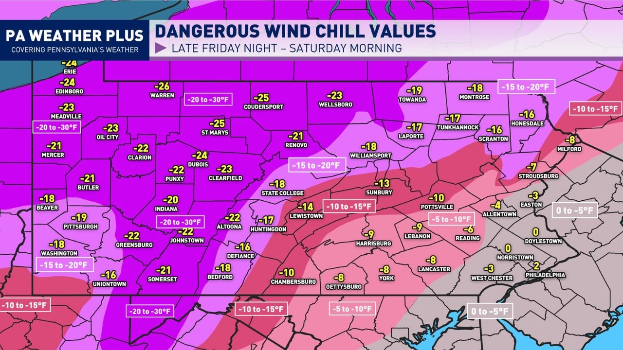
Forecast wind chill values across Pennsylvania include:
- –20°F to –30°F across northwestern and north-central Pennsylvania
- –15°F to –20°F across much of central Pennsylvania
- –10°F to –15°F extending into parts of south-central Pennsylvania
- 0°F to –5°F near southeastern Pennsylvania, including the Philadelphia metro area
Even areas that typically avoid the worst arctic cold will still experience dangerous exposure levels during the peak of the event.
Cold Exposure Risks Increase Rapidly at These Levels
When wind chill values drop this low, the human body loses heat much faster than air temperature alone suggests. Strong winds strip warmth from exposed skin, dramatically increasing the risk of frostbite and hypothermia.
At wind chills below zero, frostbite can develop in as little as 10–30 minutes, especially on hands, ears, nose, and cheeks. Hypothermia can also occur more quickly, particularly for anyone outdoors for extended periods, improperly dressed, or exposed to wind without shelter.
Even temperatures that may not appear extreme on a thermometer become dangerous when combined with strong winds, making this event especially hazardous.
Cold Will Linger Through Saturday Night With Little Improvement
Forecast guidance shows minimal relief Saturday afternoon, with wind chills remaining below zero in many locations. As winds persist into Saturday night, dangerous conditions are expected to continue, especially across central and northern Pennsylvania.
This prolonged exposure window increases concerns for overnight travel, outdoor workers, and anyone attending evening events or early-morning activities through the weekend.
Safety Precautions Strongly Advised Statewide
Anyone planning to be outdoors Friday night through Saturday and into Sunday should take serious cold-weather precautions. Dress in multiple loose-fitting layers, starting with a moisture-wicking base layer, followed by an insulating middle layer such as fleece or wool, and finishing with a windproof, waterproof outer shell.
All exposed skin should be covered. A hat, insulated gloves, scarf or face covering, and waterproof insulated boots with thick socks are strongly recommended. Hands, ears, nose, and cheeks are typically the first areas affected by frostbite.
Limiting time outdoors, taking frequent warm-up breaks, and checking on vulnerable individuals will be critical during this period.
What This Means for Travel and Weekend Events
The combination of extreme cold and strong winds may affect travel comfort, vehicle reliability, and outdoor event attendance across Pennsylvania. Late-night concerts, early-morning events, and weekend travel plans may require extra preparation, especially in exposed or rural areas.
While snowfall is not the primary concern, the cold itself poses the greatest risk, making awareness and preparation essential.
For continued Pennsylvania weather updates, cold safety guidance, and how severe conditions could impact travel and live events, visit ChicagoMusicGuide.com.