Snow Showers and 50 MPH Wind Gusts to Slam Maryland, Virginia, Pennsylvania and Washington, D.C. as Powerful Cold Front Arrives Friday Night
UNITED STATES — A powerful arctic cold front is expected to sweep through the Mid-Atlantic region Friday afternoon into Friday night, bringing snow showers, very strong winds, and a rapid return to frigid air across Maryland, Virginia, Pennsylvania, and Washington, D.C. Forecast data shows this system may produce wind gusts strong enough to cause power outages, followed by dangerously cold wind chills lasting into the weekend.
Cold Front Arrival Timing and Overall Setup
Forecast guidance indicates the cold front will move through the region between 1 p.m. and 10 p.m. Friday, progressing west to east. Ahead of the front, temperatures will be relatively milder, but conditions will change quickly once the boundary passes.
As the front pushes through, cold arctic air will surge into the Mid-Atlantic, setting the stage for snow showers, rapidly falling temperatures, and increasingly dangerous conditions overnight into Saturday morning.
Snow Showers Possible With Brief Heavy Bursts
Snow showers are expected to accompany the frontal passage Friday afternoon and evening. While these snow showers will be hit-or-miss, some may become briefly heavy, particularly across northwestern Maryland, south-central Pennsylvania, and areas northwest of the Beltway.
In these locations, a quick coating of snow is possible, especially on untreated roads and elevated surfaces. While widespread accumulation is not expected, the sudden nature of the snow could lead to slick travel conditions during the evening commute.
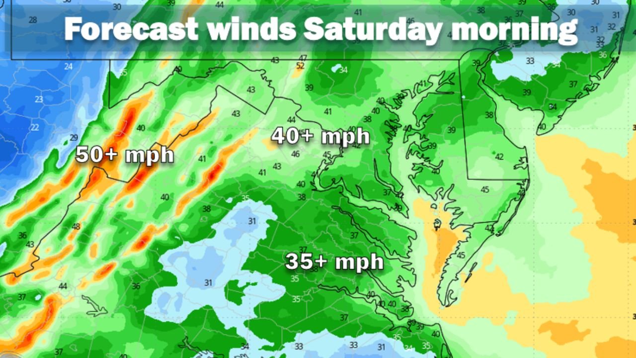
Wind Becomes the Primary Threat With Gusts Near 50 MPH
The most significant impact from this system will be strong to potentially damaging winds. After the front passes, wind gusts of at least 40 mph are expected late Friday night into Saturday, with isolated gusts approaching 50 mph, especially across Maryland, eastern Pennsylvania, Virginia, and the District of Columbia.
These winds may be strong enough to down tree limbs, disrupt travel, and trigger scattered power outages. The National Weather Service has indicated that wind advisories or warnings are likely to be issued for parts of the region as the event draws closer.
Dangerously Cold Wind Chills Follow Into Saturday and Sunday
As winds remain strong and temperatures continue to fall, dangerously cold wind chills will develop late Friday night and persist through Saturday and into Sunday. Even as actual air temperatures stabilize, the wind will continue to strip heat away from exposed skin.
Forecast guidance warns that wind chills may drop well below zero in parts of Pennsylvania, with single-digit or subzero wind chills extending into Maryland, Virginia, and the D.C. metro area. The Weather Service notes that the combination of wind and cold will significantly increase the risk of frostbite and hypothermia.
Impacts on Travel, Power, and Outdoor Events
The combination of snow showers, high winds, and rapidly falling temperatures could make travel hazardous Friday night and early Saturday. Power outages are possible where wind gusts are strongest, particularly in areas with saturated or weakened trees.
For those planning concert travel, outdoor events, or late-night activities across the Mid-Atlantic, conditions may become uncomfortable and potentially dangerous quickly. Even short periods outdoors could pose a risk once wind chills plunge.
Cold Weather Safety Precautions Strongly Recommended
Anyone spending time outdoors from Friday night through the weekend should dress in multiple loose-fitting layers, including a moisture-wicking base layer, an insulating middle layer, and a windproof outer shell. All exposed skin should be covered with hats, gloves, scarves, and insulated footwear.
Hands, ears, nose, and cheeks are especially vulnerable to frostbite when wind chills fall this low. Limiting time outdoors and staying informed of updated advisories will be critical as this system moves through.
For continued Mid-Atlantic weather updates, travel impact coverage, and how severe conditions could affect live music plans and weekend events, visit ChicagoMusicGuide.com.