Coastal Snow Squalls and Ocean-Effect Bands Target Massachusetts, New Hampshire, and Maine as Eastern New England Sees Localized Heavy Snow
MASSACHUSETTS, NEW HAMPSHIRE, AND MAINE — A complex winter setup is unfolding across eastern New England as coastal enhancement, frontal forcing, and ocean-effect snow bands combine to produce sharply varying snowfall totals from inland areas to the immediate coastline. While widespread snowfall remains modest, localized bursts near the coast are expected to intensify rapidly, behaving more like snow squalls than steady snow.
The setup favors eastern Massachusetts, coastal New Hampshire, and parts of southern Maine, where overlapping enhancement zones are expected to briefly push snowfall rates higher than surrounding areas.
How Frontal Enhancement Sets the Stage Inland
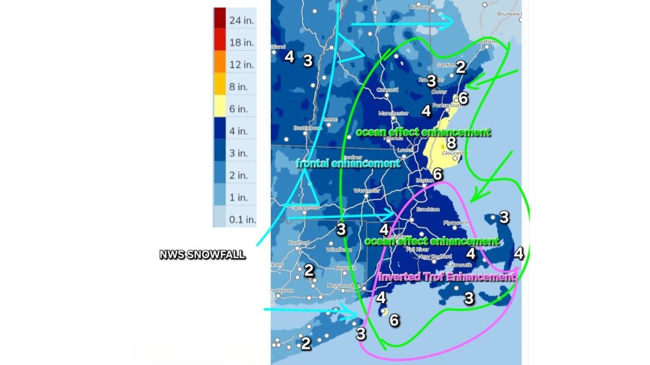
Inland portions of Massachusetts, southern New Hampshire, and northern Connecticut are positioned beneath a frontal enhancement zone, where lift along the advancing boundary helps generate steady snowfall.
Most inland communities are projected to see 2 to 4 inches, with locally higher totals closer to the transition zone where frontal forcing overlaps with coastal moisture. Snowfall here is expected to be more consistent but generally lighter compared to coastal bands.
Ocean-Effect Enhancement Along the Massachusetts Coast
The most notable enhancement is expected along the Massachusetts coastline, especially from Boston northward through Gloucester.
Ocean-effect enhancement occurs as cold air moves over relatively warmer ocean waters, allowing narrow but intense snow bands to develop. In these areas, snowfall totals could reach 6 to 8 inches, with brief periods of rapidly reduced visibility.
These bands may fluctuate sharply over short distances, meaning neighborhoods just miles apart could see significantly different accumulations.
Inverted Trough Adds Snowfall to Cape Cod and Southeastern Massachusetts
An inverted trough enhancement is evident across Cape Cod, Plymouth County, and parts of southeastern Massachusetts, where additional lift enhances snowfall offshore and near the coast.
Snowfall amounts in these areas are expected to range from 3 to 6 inches, with localized pockets pushing higher where ocean-effect and trough-driven bands intersect.
New Hampshire and Maine See Coastal Boost, Lower Inland Totals
Along the New Hampshire Seacoast, including Portsmouth, snowfall totals of 4 to 6 inches are possible where ocean-effect bands clip the coast.
Farther north into southern Maine, including Portland, totals generally range from 2 to 4 inches, with locally higher amounts closer to the shoreline. Inland areas of Maine see lower totals as moisture decreases away from the coast.
What This Means for Concerts, Venues, and Weekend Travel
For live music fans and venue operators across Boston, Cape Cod, and coastal New England, the biggest concern will be timing, not total snowfall. Snow may fall in short, intense bursts that coincide with evening travel windows, making commutes unpredictable even where totals remain moderate.
Localized squall-like bands could briefly overwhelm roads near coastal corridors, impacting attendance and late-night travel more than inland locations experiencing steadier snowfall.
As winter weather continues to influence regional travel and nightlife planning, ChicagoMusicGuide.com will keep tracking weather patterns that affect concerts, venues, and weekend plans across the country.