Florida Weather Forecast Raises Questions for Daytona 500 Weekend as Models Show Major Uncertainty
FLORIDA — With the Daytona 500 just days away, weather models are sending mixed and conflicting signals for race weekend across Florida, leaving forecasters cautious as a potential cold front comes into focus but with unclear timing, placement, and intensity.
Meteorologists reviewing the latest guidance say a frontal boundary looks increasingly likely, but beyond that, confidence drops sharply. The difference between leading global models is significant enough that officials and fans alike are being urged to stay flexible.
Why Weather Confidence Is Low Right Now
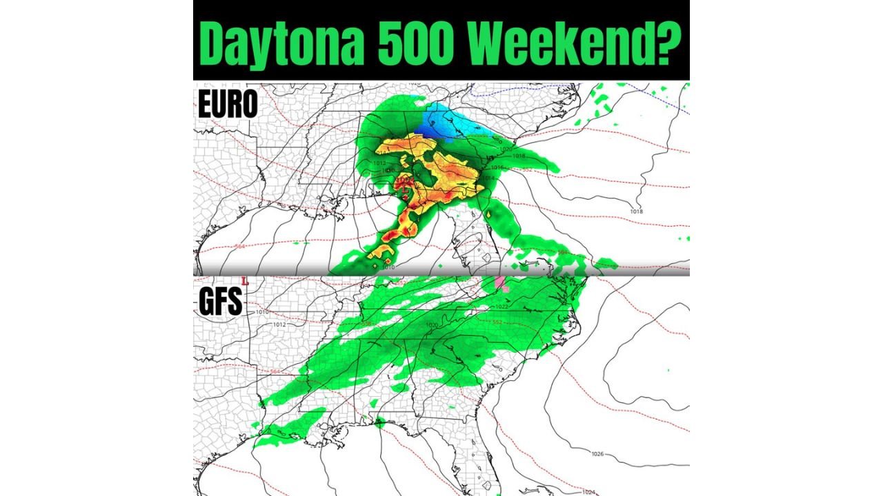
Current model guidance shows strong disagreement between the EURO and GFS models, particularly regarding how far south rain and storms could push into Florida.
- The EURO model depicts a more aggressive system, with widespread rain and possible thunderstorms impacting central and northern Florida near race weekend.
- The GFS model, however, keeps the heaviest precipitation farther north, limiting Florida impacts mainly to cloud cover and scattered light showers.
This level of divergence indicates the atmosphere has not yet locked into a consistent pattern, making precise forecasting difficult this far out.
What Models Agree On: A Front Is Likely
Despite the uncertainty, both models do share one important takeaway:
A cold front is likely to be somewhere in the Southeast during race weekend.
What remains unclear is:
- Where the front stalls
- When it arrives
- How much moisture it can tap into
Small shifts in the jet stream or storm track could dramatically change outcomes for Daytona Beach and surrounding areas.
Temperature and Wind Could Still Be a Factor
Even if rain stays limited, cooler air behind the front could impact race conditions, especially during morning hours.
Potential impacts include:
- Breezy conditions along the coast
- Cooler-than-average temperatures for Florida standards
- Variable wind direction that could affect track conditions
This setup raises concerns not just for precipitation, but also driver visibility, tire strategy, and fan comfort.
Why Forecasters Are Taking a Wait-and-See Approach
Meteorologists emphasize that this is one snapshot in a long-range forecast window. Similar setups in the past have seen dramatic shifts within 48–72 hours of the event.
At this stage:
- There is no clear trend yet
- Confidence remains moderate to low
- Additional model runs are needed before drawing firm conclusions
Forecasters are watching for model convergence, which would signal that the atmosphere is beginning to settle on a more predictable outcome.
What This Means for Fans Traveling to Daytona Beach
For now, the best advice is preparation without panic.
- Plan for variable weather
- Bring layers for cooler temperatures
- Monitor forecasts daily as confidence improves closer to race day
Race weekend weather in Florida often comes down to timing, and even a few hours’ difference could mean the difference between dry conditions and delays.
What Comes Next
Meteorologists expect clearer signals once models move inside the 5–7 day window, where accuracy improves significantly. Until then, updates will continue as forecasters look for signs of consistency.
Weather remains one of the biggest unknowns heading into one of NASCAR’s most anticipated weekends.
Stay tuned to ChicagoMusicGuide.com for continued weather updates tied to major events and travel plans across the U.S.