GFS and ICON Signal Heavier Snow Tuesday Night as Great Lakes to New England Brace for Widespread Winter Storm
UNITED STATES — Updated GFS and ICON model data shows a strengthening winter system set to deliver another round of accumulating snow Tuesday night into early Wednesday, impacting a broad corridor from the Upper Midwest and Great Lakes through New England. Forecast guidance highlights a renewed push of colder air and enhanced moisture, raising confidence in moderate to locally heavy snowfall totals across multiple states.
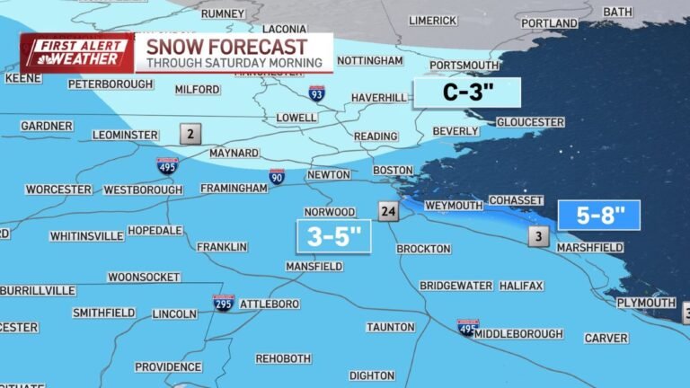
Model consensus now points toward widespread 3 to 6 inch totals, with localized amounts exceeding 7 to 8 inches in parts of the Upper Great Lakes and interior New England, as the system consolidates and deepens overnight Tuesday.
GFS Highlights a Heavier Snow Band Across the Great Lakes
The latest GFS 0.25° snowfall output paints a well-defined snow swath extending from northern Minnesota and Wisconsin, eastward across Michigan, northern Illinois, Indiana, Ohio, and into upstate New York. Within this band, the model consistently signals 4 to 6 inches of snow, with isolated pockets approaching 7 inches, particularly near Lake Superior and Lake Michigan’s northern shoreline.
Snowfall intensity is expected to increase late Tuesday evening, coinciding with strengthening lift and colder mid-level temperatures. Urban corridors near Chicago, Milwaukee, Detroit, and Cleveland fall within the moderate accumulation zone, suggesting slippery roads and reduced visibility during the overnight hours.
ICON Model Reinforces Snow Threat Into Interior New England
The ICON 13 km guidance closely mirrors the GFS trend but extends the more substantial snow threat farther east. As the system tracks toward the Northeast, interior sections of New York, Vermont, New Hampshire, and Maine show solid 3 to 5 inch accumulations, with locally higher totals in elevated terrain.
Coastal areas appear closer to the rain-snow transition zone, but inland cold air support favors snow dominance, particularly north of the I-90 corridor. The ICON solution supports the idea that snow will linger into early Wednesday morning, even as the system begins to weaken farther west.
Timing Focused on Tuesday Night Into Early Wednesday
Both models agree on timing, showing snow developing or intensifying Tuesday evening, peaking overnight, and tapering off Wednesday morning from west to east. The strongest forcing aligns with the 06z to 12z Wednesday window, which may bring periods of steady, moderate snowfall during the most impactful travel hours.
This timing raises concern for early-morning commutes, particularly across the Great Lakes states and interior New England, where untreated roads may quickly become snow-covered.
Snow Type and Accumulation Efficiency
Model soundings suggest a high snow-to-liquid ratio, especially in colder inland zones. This means lighter, fluffier snow capable of accumulating efficiently, even where liquid precipitation totals remain modest. Areas under persistent banding could see rapid accumulation in a short time, increasing the risk of slick conditions despite relatively low precipitation rates.
Impacts Expected Across Multiple States
While this system does not currently signal blizzard conditions, its wide footprint and overnight timing make it impactful. Expected effects include:
- Snow-covered roads and reduced visibility
- Slower travel during late-night and morning hours
- Localized school and travel disruptions
- Hazardous conditions near lakes and higher elevations
Motorists and travelers across Illinois, Wisconsin, Michigan, Ohio, New York, and New England are urged to monitor local forecasts as final snowfall totals and rain-snow lines continue to refine.
Forecast Confidence and What to Watch Next
Confidence is increasing due to strong agreement between the GFS and ICON models, though exact snowfall placement may still shift slightly north or south. Small track changes could significantly affect totals in metro areas near transition zones.
Additional model updates over the next 24 hours will help clarify where the heaviest snow ultimately falls and whether any regions trend higher or lower than current projections.
As winter conditions continue to evolve across the Midwest and Northeast, staying prepared remains essential. For continued weather updates, regional impacts, and winter travel outlooks across the Midwest and beyond, visit ChicagoMusicGuide.com.