Maryland and Pennsylvania Track Potential Feb. 15–16 Winter Storm as Baltimore Metro Sees 30–40% Chance of 3 Inches or More of Snow
BALTIMORE, MARYLAND — Meteorologists are closely monitoring a potential winter storm that could impact parts of Maryland, Pennsylvania, and the Mid-Atlantic around February 15–16, though confidence remains limited due to the system’s long-range status. Current guidance suggests the storm is unlikely to be a pure snow event, with rain and sleet mixing in, especially closer to the coast.
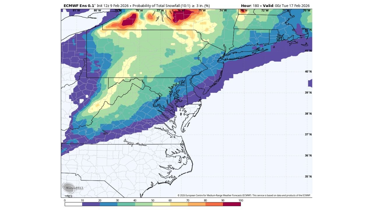
Even so, the latest ECMWF ensemble data indicates a 30–40% probability that the Baltimore metro area could receive at least 3 inches of snow, a signal strong enough to warrant early attention.
Long-Range Tracking Still In Early Stages
Forecasters stress that this system is still in the early tracking phase, meaning key details such as storm track, temperature profiles, and precipitation type remain highly uncertain. Small shifts in the system’s path or timing could dramatically change snowfall outcomes, particularly across the Interstate 95 corridor.
At this range, ensemble guidance is more useful for identifying risk, not exact totals — and the risk is clearly present for a measurable winter event in parts of the region.
Mixed Precipitation Likely For Many Areas
Based on current temperature profiles, this storm will likely feature mixed precipitation, especially across central and eastern Maryland, including Baltimore and surrounding suburbs. Warmer air aloft raises the potential for rain or sleet, which could limit snowfall accumulation in lower elevations and near the Chesapeake Bay.
Farther inland — including portions of central and northern Pennsylvania — colder air may support a higher ratio of snow, increasing the odds for more impactful accumulations if the storm trends colder.
ECMWF Ensembles Show Focused Snow Potential Inland
The ECMWF ensemble probability maps highlight the highest chances for 3+ inches of snow across inland sections of Pennsylvania and northern Maryland, with probabilities gradually decreasing closer to the coast.
For the Baltimore metro, the 30–40% probability places the region in a meaningful but uncertain zone, where outcomes could range from mostly rain to a plowable snow depending on subtle atmospheric changes.
This type of setup is common in Mid-Atlantic winter storms, where rain–snow lines can shift dramatically within short distances.
Timing Window Centers On Feb. 15–16
The most likely window for impacts currently appears to be late Saturday into Sunday (Feb. 15–16). However, forecasters caution that timing remains flexible and could shift earlier or later as models resolve the system more clearly.
If the storm slows or strengthens, colder air could become better established — increasing snow potential. A faster or weaker system would favor rainier outcomes.
What Residents Should Watch Over The Next Week
While it is far too early to lock in totals or impacts, residents across Maryland and Pennsylvania should keep an eye on forecast updates, especially if travel or events are planned for that weekend.
Key factors to watch include:
- Trends in storm track (north vs. south)
- Strength of cold air at the surface
- Changes in ensemble snowfall probabilities
As confidence gradually improves in the days ahead, clearer answers will emerge on whether this system becomes a minor mixed event or a more disruptive winter storm. For continued updates on Mid-Atlantic winter weather, storm tracking, and forecast changes, visit ChicagoMusicGuide.com for the latest coverage.