Major Pattern Shift Signals Heavy Western Snow and a Complex Midwest–East Storm Setup Through Mid-February
UNITED STATES — A significant mid-February pattern change is taking shape across the Lower 48, and the latest model guidance shows a split story developing between the West, the Central U.S., and the East. While much of the country trends warmer than average heading into next week, multiple storm systems remain active — including a high-impact snow cycle for the western mountains and a complex rain-to-snow setup stretching from the Southern Plains into the Midwest and Great Lakes region.
Meteorologists tracking this setup emphasize that while some operational model runs have trended warmer overnight, ensemble guidance continues to support a meaningful winter weather signal — especially in areas where cold air timing remains uncertain.
Storm Track Shifts Warmer, But Winter Signal Remains
Recent operational runs show the primary storm system arriving later than initially projected. That delay allows cold air to retreat northward, increasing the likelihood of rain or mixed precipitation across parts of the Southeast and lower Ohio Valley rather than a clean snowstorm.
However, ensemble guidance — which carries more weight at this forecast range — still holds onto a steady snow signal across parts of the Midwest, Great Lakes, interior Northeast, and higher elevations of the Appalachians. This creates a high-uncertainty forecast where precipitation type will be highly sensitive to small temperature changes.
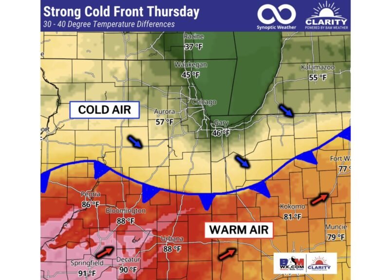
For Chicago and surrounding areas, this means the setup cannot yet be dismissed as “too warm.” Even modest shifts in the storm track could quickly reintroduce snow potential.
Midwest and Great Lakes: Rain, Snow, or Both
Forecast maps show a deepening low pressure system tracking from the Southern Plains toward the Ohio Valley before lifting northeast. On its northern flank, colder air could support snow across portions of the Midwest and Great Lakes, while warmer air surges northward to the south and east.
This type of setup favors:
- Heavy rain and thunderstorms across parts of the Deep South and Tennessee Valley
- A rain-snow transition zone across Missouri, Illinois, Indiana, and Ohio
- Higher snow probabilities across Michigan, northern Wisconsin, and interior New England
Exact impacts will depend on how quickly cold air can reestablish itself as the storm intensifies.
Weeks 1 and 2: Warmer Central U.S., Cooler Coasts
Temperature anomaly outlooks for both Week 1 and Week 2 show much of the Central United States running above average, while the West Coast and East Coast remain closer to seasonal norms or slightly below.
This pattern is supported by a developing negative Pacific-North American (-PNA) configuration, combined with near-neutral Arctic Oscillation (AO) and North Atlantic Oscillation (NAO). The result is persistent troughing in the West and ridging across the central part of the country.
Despite the warmer averages, storm systems remain active — meaning winter weather threats are not eliminated, only more dependent on timing and elevation.
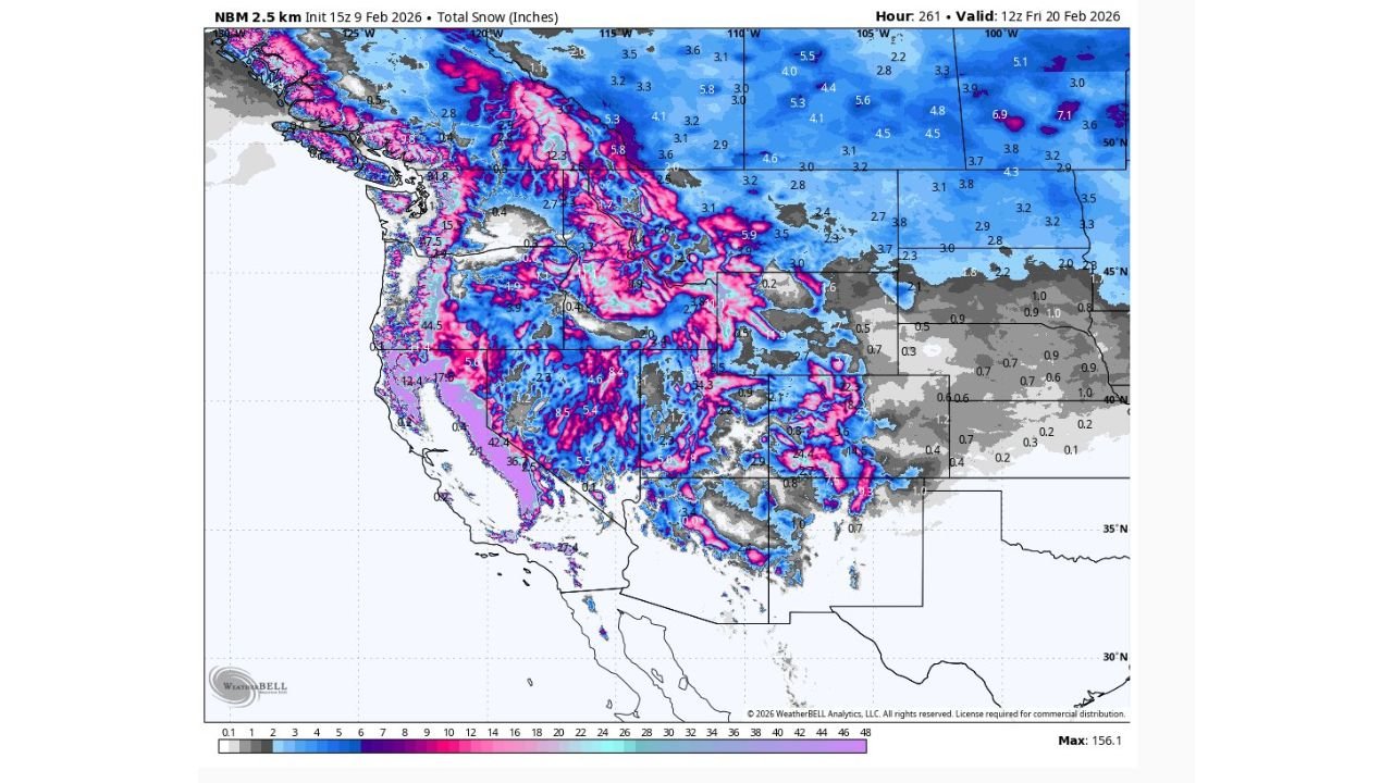
Western Mountains Brace for a High-End Snow Cycle
The clearest winter signal in the forecast lies across the western United States. A productive storm cycle is now underway, delivering desperately needed snow to mountain regions from the Pacific Northwest through the Sierra Nevada and into the Rockies.
Snowfall projections indicate:
- Widespread multi-foot totals across higher elevations
- Sierra Nevada hotspots potentially reaching 50–100 inches of snow in favored areas
- Continued snow accumulation through at least mid-February
This marks a major turnaround after weeks of quieter conditions and will significantly boost snowpack and water resources.
Severe Weather Not Ruled Out in the South
As storm energy ejects eastward from the western trough, above-average precipitation is expected across parts of the Southern Plains and Mid-South beginning this weekend and continuing into next week.
With warmer air in place, severe thunderstorms cannot be ruled out, particularly in areas where strong wind shear overlaps with surging Gulf moisture. This adds another layer of complexity to an already active weather pattern.
What to Watch Next
Key forecast questions over the next several days include:
- How quickly cold air returns behind the storm system
- Whether the rain-snow line shifts north or south
- How much snow ultimately reaches the Midwest and Great Lakes
- The longevity of the western snow cycle
Small changes in storm timing will have outsized impacts — especially for cities like Chicago sitting near the transition zone.
Weather patterns remain dynamic, and confidence will improve as systems move closer to the short-range window.
Stay tuned to ChicagoMusicGuide.com for continued updates as this evolving mid-February weather pattern takes shape — and let us know how conditions are unfolding where you live.