Mid-February Pattern Shift Brings Widespread Snow Across California, Oregon, Washington, Idaho, Montana, Utah, Colorado, Wyoming, and New Mexico
UNITED STATES — A long-awaited mid-February atmospheric pattern shift is now underway, delivering widespread snowfall across the Western United States, with impacts stretching from California and Oregon through the Northern Rockies and into the Southwest. Forecast snowfall data covering February 8–14 shows multiple mountain corridors positioned for sustained accumulation, signaling one of the most productive winter stretches so far this season for many regions.
This evolving setup marks a clear transition toward a more active and colder western storm track, favoring repeated snow events rather than isolated systems.
California and Oregon Mountains Targeted for Repeated Snowfall
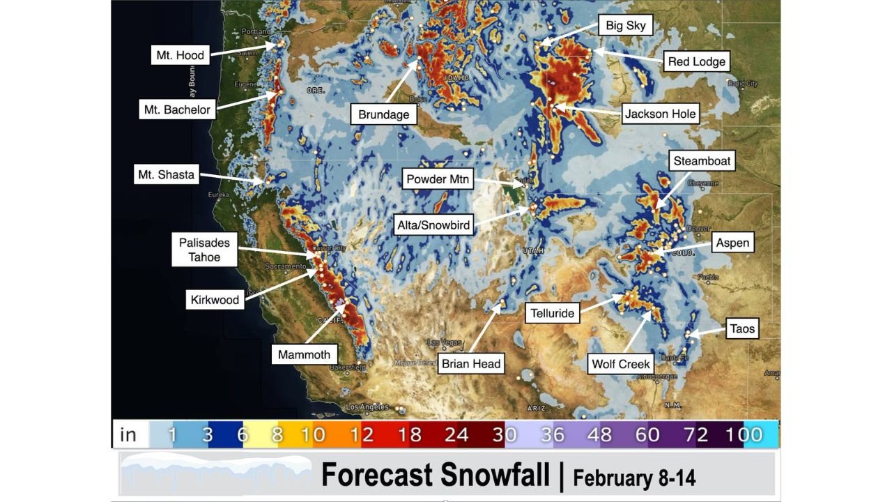
Across California, the Sierra Nevada stands out as one of the most consistent snowfall zones during this period. Palisades Tahoe, Kirkwood, and Mammoth Mountain are all positioned within deep snow bands, with forecast totals indicating double-digit accumulations at higher elevations. Farther north, Mount Shasta in Northern California is also expected to receive multiple rounds of snow as storms continue to roll inland.
In Oregon, mountain locations such as Mount Hood and Mount Bachelor sit beneath persistent snowfall signals, supported by steady Pacific moisture and favorable temperatures. These areas are likely to see snow spread out over several days, enhancing base depth rather than delivering short-lived bursts.
Washington and Idaho Enter a Strong Mid-Winter Snow Cycle
In Washington State, higher elevations are included within the broader snowfall footprint associated with this pattern shift, while farther inland, Idaho sees a notable expansion of snow coverage. Brundage Mountain and surrounding terrain are highlighted for consistent snowfall, reflecting a storm track well-aligned with central Idaho’s mountain ranges.
This setup favors reliable snow production rather than marginal events, helping reinforce seasonal snowpack across the region.
Montana and Wyoming Among the Heaviest Snow Zones
Some of the most intense snowfall signals appear across Montana, particularly near Big Sky and Red Lodge, where forecast maps show deep, concentrated accumulation zones. These areas often thrive under prolonged storm cycles, and this pattern aligns well with historical high-output setups.
In Wyoming, Jackson Hole is firmly embedded within a snow-favorable corridor. Forecast data suggests steady accumulation across multiple days, supporting high-quality snow conditions and continued base-building through mid-February.
Utah and Colorado See Broad Mountain Snow Coverage
Across Utah, snowfall coverage is widespread across both northern and southern mountain regions. Powder Mountain and Alta/Snowbird stand out for repeated snowfall chances, while Brian Head in southern Utah also benefits from the broader storm pattern.
In Colorado, several major mountain zones fall under consistent snow bands. Steamboat and Aspen are highlighted for recurring accumulation rather than a single dominant storm, increasing confidence in meaningful totals through the forecast window. Farther southwest, Telluride and Wolf Creek sit within zones that historically perform well during active mid-winter patterns.
New Mexico Joins the Western Snowfall Pattern
The reach of this mid-February shift extends into the Southwest, with Taos, New Mexico, included within the broader snowfall footprint. While totals may vary compared to the Northern Rockies, the signal for measurable snowfall reflects how expansive and organized this pattern has become across the western half of the country.
Why This Mid-February Pattern Shift Is Significant
Rather than producing isolated storm events, this setup favors layered snowfall over multiple days, allowing snowpack to build more efficiently across mountain regions. The alignment of storm tracks, cold air, and Pacific moisture makes this one of the more impactful western winter patterns seen so far this season.
For mountain communities, ski destinations, and regional water supply outlooks, this stretch may prove pivotal as February progresses.
As snowfall continues to stack up across California, Oregon, Washington, Idaho, Montana, Wyoming, Utah, Colorado, and New Mexico, ChicagoMusicGuide.com will keep tracking major weather patterns shaping travel, events, and regional conditions nationwide. Visit ChicagoMusicGuide.com for continued updates, detailed forecasts, and weather coverage tied to major destinations and seasonal trends.