GFS Model Shows Powerful Arctic Blast Targeting Midwest, Southeast and Great Lakes States by February 26, 2026
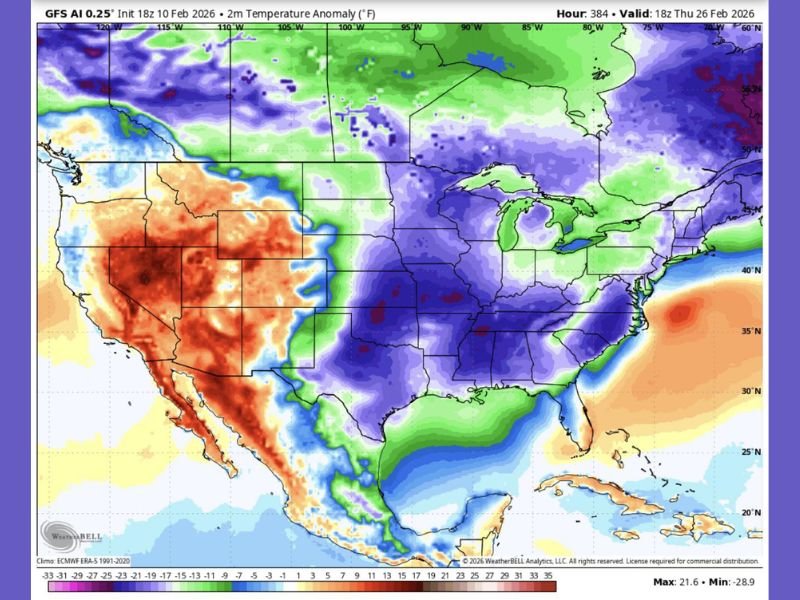
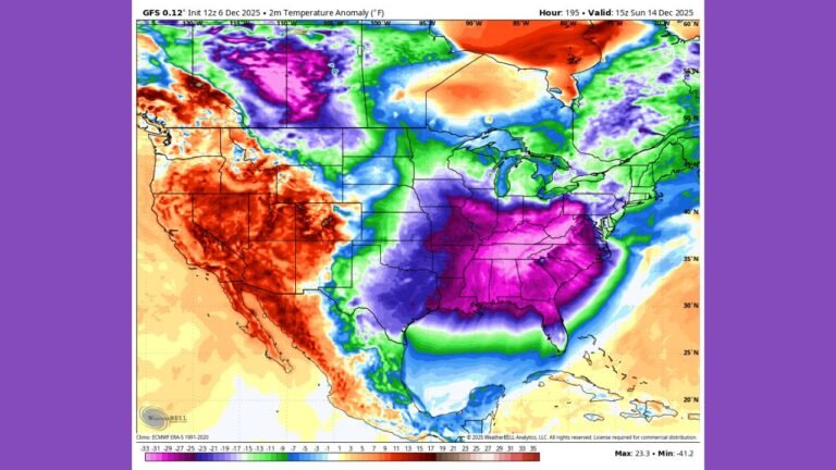
ILLINOIS — A powerful surge of Arctic air is projected to sweep across large portions of the United States by February 26, 2026, according to the latest GFS 0.25° temperature anomaly model. The data shows widespread below-normal temperatures stretching from the Northern Plains through the Midwest and deep into the Southeast, signaling a dramatic late-winter return just days before March begins.
The forecast map valid at 18z Thursday, February 26, 2026, highlights significant cold anomalies across multiple regions, with some areas running well below seasonal averages.
Arctic Core Targets the Midwest and Great Lakes
The most intense cold anomalies appear centered over the Midwest, including Illinois, Iowa, Missouri, Wisconsin, Indiana, and Michigan. Deep blue and purple shading on the model indicates temperatures potentially running 15 to 25 degrees below normal in parts of the region.
For Chicago and northern Illinois, this setup suggests a sharp return to winter conditions after any brief moderation earlier in the month. The cold dome extends across the Great Lakes, enveloping Michigan, Ohio, and western Pennsylvania, while pushing into portions of upstate New York.
This pattern signals a classic late-February Arctic intrusion, with cold air draining southward from central Canada into the heart of the country.
Southeast Faces Rare Late-Season Chill
The model also shows significant cold anomalies spreading into the Southeast, including Tennessee, Kentucky, Alabama, Mississippi, Georgia, and the Carolinas. While coastal areas may see slightly less extreme departures, inland zones appear firmly within the colder air mass.
Even parts of Arkansas and northern Louisiana show strong negative temperature anomalies. The shading suggests that much of the region could experience temperatures 10 to 20 degrees below average for late February.
Meanwhile, parts of the Mid-Atlantic, including Virginia and North Carolina, are also projected to feel the push of Arctic air, particularly away from immediate coastal influences.
Sharp Temperature Contrast Across the West
While the central and eastern United States brace for cold, the model shows a striking contrast across the Western United States. Significant warm anomalies are depicted over California, Nevada, Arizona, Utah, and New Mexico, with some areas running 15 to 20 degrees above normal.
This pronounced east-west temperature gradient is typical of amplified winter patterns, where a strong ridge dominates the West and a deep trough settles over the central and eastern U.S.
Parts of Texas appear split, with northern areas feeling the edge of the cold air mass while southern sections trend closer to seasonal norms or slightly below average.
What This Means for Late February Travel and Events
With the anomaly map showing broad cold coverage across the Midwest, Great Lakes, and Southeast, residents should prepare for another round of winter-like conditions. While this forecast focuses on temperature departures rather than snowfall totals, such strong Arctic air often increases the potential for:
- Increased heating demand
- Possible snow or ice development where moisture is present
- Hazardous travel conditions in colder states
- Strain on infrastructure during extended cold spells
For music venues, outdoor events, and community gatherings across Illinois, Indiana, Missouri, Tennessee, and Georgia, organizers may need contingency plans if the cold intensifies as projected.
A Late-Winter Reminder Before March
The timing of this projected cold blast is notable. Late February often teases early signs of spring, but the data indicates winter may not be finished just yet for much of the central and eastern United States.
The model’s maximum and minimum anomaly readings show a significant spread, underscoring how dynamic the pattern remains. While long-range forecasts can shift, the consistency of cold shading across the central U.S. suggests a meaningful signal rather than a brief cool snap.
Residents across Chicago, Detroit, Indianapolis, Nashville, Birmingham, and Atlanta should monitor updates as the date approaches. If the pattern holds, the final week of February could deliver one more memorable Arctic punch before March begins.
As the Midwest and Southeast prepare for what could be a significant late-season cold outbreak, staying informed will be critical. For continued weather coverage, regional updates, and how changing conditions may impact concerts, festivals, and live events across Illinois and beyond, visit ChicagoMusicGuide.com.