West Coast Storm to Dump 6 to 12 Inches of Snow in Sierra and Rockies, With 18 Inches Possible on Highest Peaks
CARSON CITY, NEVADA — A developing West Coast storm system is set to break the recent dry spell, delivering 6 to 12 inches of snowfall to mountain regions through Thursday, with locally up to 18 inches on the highest peaks. The system is centered near northern Nevada and the Sierra Nevada, pushing moisture inland toward the Great Basin and central Rockies.
Lower elevations along the western slope will see primarily rain showers, while higher terrain absorbs the brunt of the winter accumulation.
Sierra Nevada and Western Slopes See Significant Snow
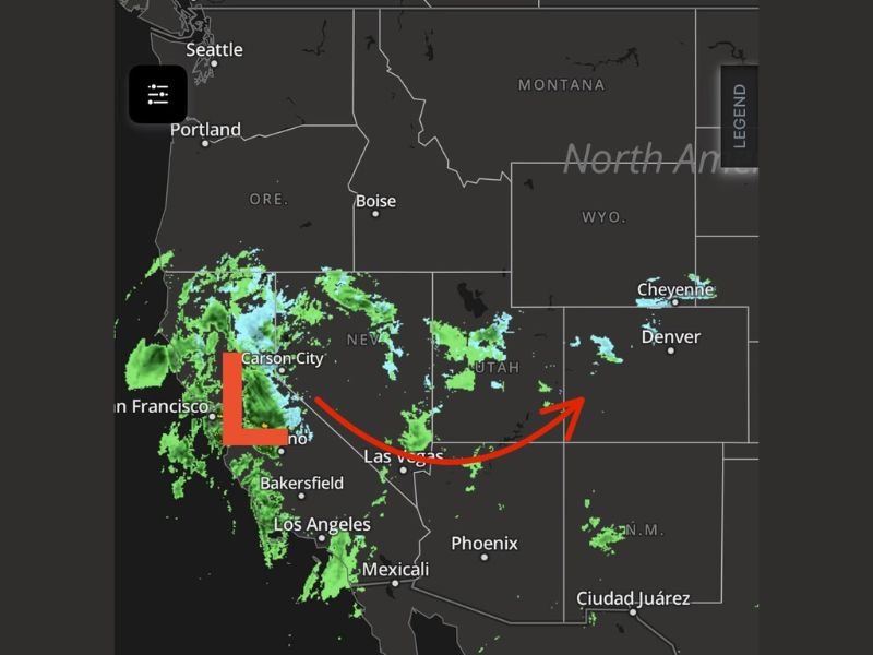
Radar imagery shows a broad precipitation shield wrapping around a low-pressure system positioned near Carson City and Reno, Nevada, extending into northern California. The moisture feed is targeting the Sierra Nevada, where elevations are high enough to support heavy snow totals.
Forecast projections call for 6 to 12 inches of snow across mountain zones, with the highest peaks potentially reaching 18 inches before the system tapers off. These are substantial accumulations capable of improving snowpack and creating travel concerns across mountain passes.
Lower elevations along the western slopes, including areas closer to Sacramento and parts of northern California valleys, are expected to experience mainly rain showers rather than snow.
Limited Precipitation East of the Divide
As the system pushes eastward into Utah and western Colorado, downslope effects will limit widespread precipitation east of the Continental Divide. While scattered rain and snow showers remain possible through Friday, it may be difficult to squeeze out consistent moisture for areas farther east.
Cities such as Salt Lake City, Las Vegas, and Denver appear on the edge of the system’s broader moisture field, with lighter and more scattered precipitation expected compared to the Sierra region.
The western slope of the Rockies may pick up some snowfall, but totals east of the Divide will likely be less impressive due to drying as air descends.
Southern Colorado and Southwest Kansas Watch Late-Week Energy
Another piece of energy moving out of New Mexico is expected to enhance precipitation chances for southern Colorado and southwest Kansas from Friday night into Saturday morning. This secondary impulse could bring additional rain or snow to those regions, depending on temperature profiles.
While not expected to match the mountain totals seen in Nevada and California, this follow-up system may still deliver measurable precipitation across portions of the southern High Plains.
Breaking the Dry Spell
The broader impact of this system is the shift away from dry conditions across the western U.S. The moisture infusion into Nevada, northern California, and parts of Utah marks a meaningful break in recent dry weather patterns.
Mountain communities and ski areas in the Sierra Nevada stand to benefit most from the snowfall, while lower elevations will see steady rain showers contributing to overall water totals.
Travelers crossing mountain passes should monitor conditions, as heavy snow at higher elevations could create slick roads and temporary closures.
As this dynamic West Coast system unfolds and additional energy follows later in the week, staying informed will be key for travel plans and outdoor events. For continued national weather updates and coverage of how changing conditions may affect festivals, concerts, and live gatherings across the country, visit ChicagoMusicGuide.com.