Valentine’s Day Severe Weather Threat Builds Across Texas and Louisiana as Strong Storm System Targets the Southern Plains
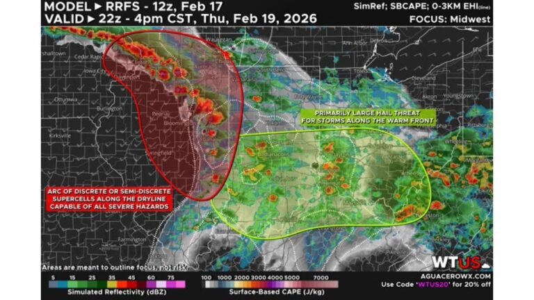
HOUSTON, TEXAS — A developing storm system expected to eject across the Southern Plains on Valentine’s Day (February 14) is raising concerns for potential severe weather across southeastern Texas into Louisiana. Forecast guidance highlights an overlap of strong atmospheric instability and powerful upper-level winds — a combination that often signals an environment capable of supporting strong to severe thunderstorms.
The projected setup shows the core of storm energy lifting out of the Southwest and spreading into Texas, with the most favorable severe parameters extending east into Louisiana. While details remain several days out, the early signal is strong enough to warrant attention, especially for residents with evening plans.
Why Southeast Texas and Louisiana Are in Focus
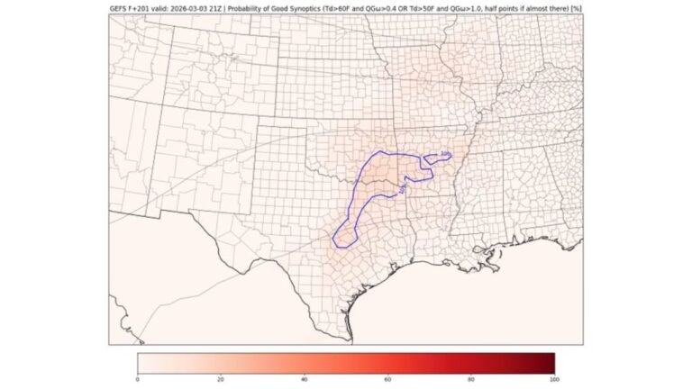
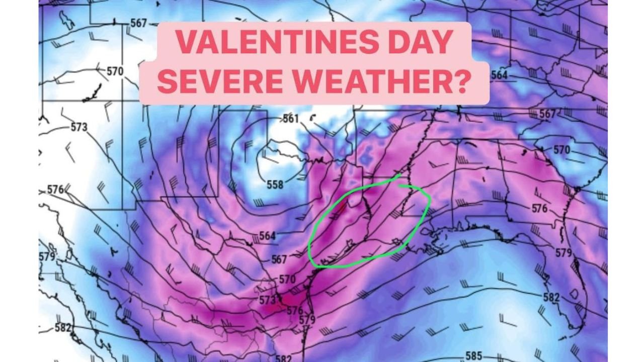
The atmospheric pattern shown in the forecast imagery indicates a robust trough swinging into the region. Height contours and wind barbs suggest strengthening upper-level dynamics over eastern Texas, with energy consolidating along a corridor from near the Texas Gulf Coast into western and central Louisiana.
The highlighted zone across southeastern Texas into Louisiana appears positioned where instability from Gulf moisture overlaps with strong kinematics — meaning favorable wind shear and storm organization potential. When instability and wind energy align this way, it can support organized thunderstorm clusters, rotating storms, or squall lines capable of damaging winds and isolated tornadoes.
The Gulf of Mexico will likely serve as a moisture source, increasing dew points ahead of the system. If daytime heating contributes additional lift, storm intensity could increase during the afternoon and evening hours on February 14.
Timing: Valentine’s Day Evening Could Be Active
Current projections suggest the most active window may occur during the afternoon into evening period on Valentine’s Day, particularly for communities along and east of the Interstate 45 corridor, including Houston, and extending toward Lake Charles, Louisiana, and surrounding areas.
Even if storms begin earlier in western Texas, the stronger dynamics appear to focus on the southeastern portion of the state before shifting into Louisiana. The exact timing and placement of the most intense storms will depend on how quickly the upper-level system ejects and how much instability builds ahead of it.
Residents planning dinners, concerts, or travel across Texas and Louisiana should monitor updates as we move closer to Friday. Severe weather setups in mid-February are not unusual in the Deep South, especially when a strong Pacific-origin system taps Gulf moisture.
What Makes This Setup Notable
The key ingredient in this developing pattern is the overlap of:
- Strong upper-level wind fields
- Increasing low-level moisture from the Gulf
- A lifting mechanism from the approaching trough
- A concentrated corridor of instability
When those factors align, forecasters often describe the setup as “kinematically favorable,” meaning storms that develop have the structural support to become organized and potentially severe.
While it is too early to define exact threat categories, the ingredients suggest at least a risk for strong thunderstorms, with the potential for damaging wind gusts and heavy rainfall. If low-level shear increases enough, isolated tornado development cannot be ruled out — especially across southeastern Texas into western Louisiana.
Looking Ahead
Forecast confidence will improve over the next several days as models better resolve the incoming energy. The system has yet to fully move inland, meaning adjustments are still possible in track, timing, and intensity.
For now, residents across Houston, Beaumont, Galveston, Lake Charles, and surrounding Gulf Coast communities should stay weather-aware heading into Valentine’s Day. Even small shifts in the storm’s track could move the highest threat zone slightly east or west.
We will continue monitoring this developing situation and provide timely updates as new data becomes available. For more regional weather coverage and updates affecting fans, venues, and travel plans across the country, visit ChicagoMusicGuide.com for the latest forecasts and insights.