Sierra Nevada Braces for 5+ Feet of Snow as Major Western Storm Cycle Targets California and Mountain West Through February 18
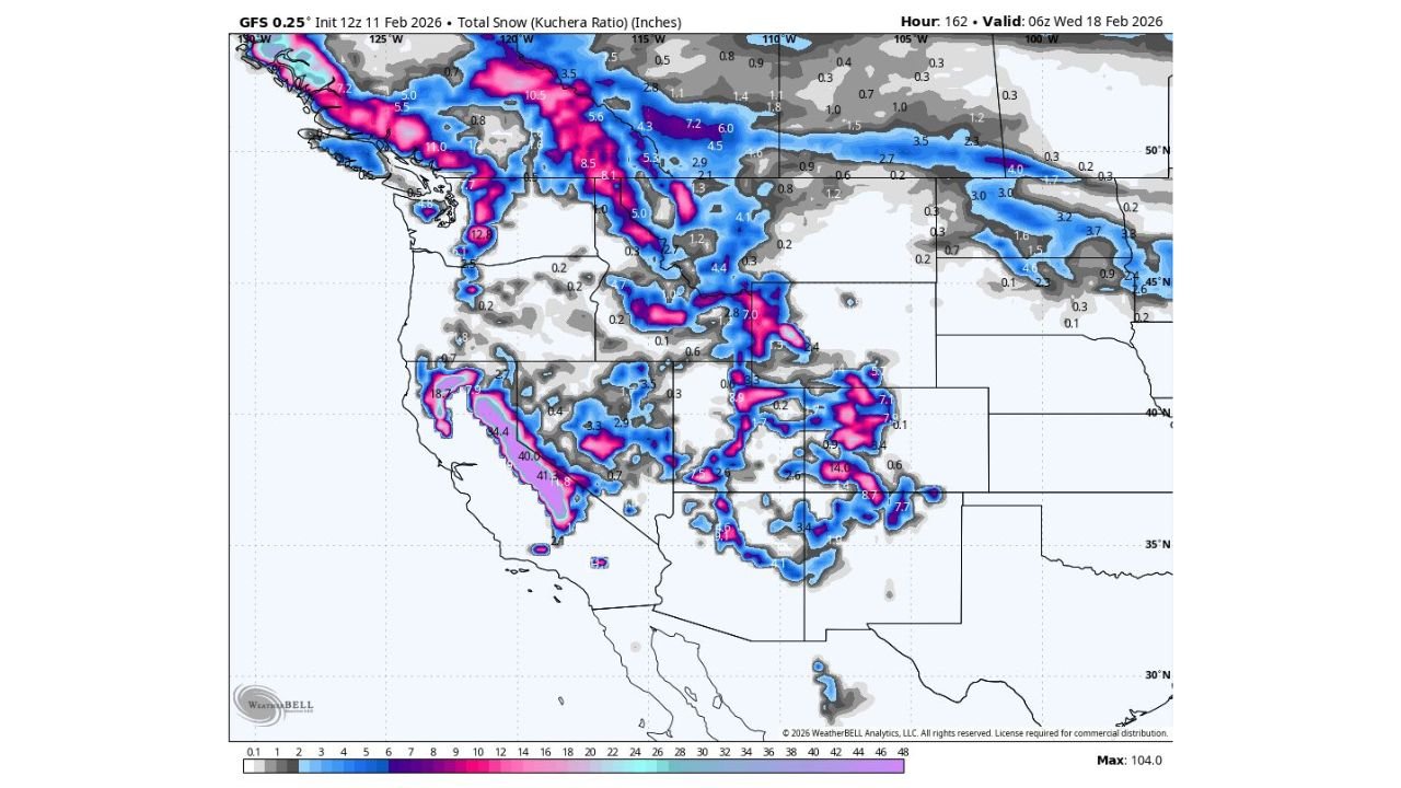
SACRAMENTO, CALIFORNIA — A powerful winter pattern is setting up across the Western United States, with forecast data indicating that more than five feet of snow could fall in the Sierra Nevada over the next week. Model projections through February 18 show the highest accumulations centered over the Sierra, where 60 inches or more of total snowfall is possible in favored higher elevations.
This developing storm cycle does not just impact California. Snowfall is projected across multiple mountain ranges in the West, including parts of Oregon, Washington, Idaho, Montana, Utah, Colorado, Arizona, and New Mexico, but the most extreme totals are concentrated in the Sierra Nevada corridor.
Sierra Nevada Could See 60+ Inches of Snow
The forecast map highlights the central and southern Sierra Nevada as the epicenter of heavy accumulation. Bright coloration over the mountain spine suggests widespread totals exceeding 40 inches, with several zones pushing toward or beyond 60 inches.
Higher elevations along the Sierra crest appear most favored, particularly from near Lake Tahoe southward toward Mammoth Mountain. These totals align with a multi-day storm sequence rather than a single event, meaning snowfall may arrive in waves.
Such accumulation is significant not only for winter recreation but also for long-term water supply. The Sierra snowpack plays a critical role in feeding California’s reservoirs during the spring melt season.
Widespread Mountain Snow Across the West
Beyond California, snow bands extend north into the Cascade Range in Washington and Oregon, where moderate to heavy totals are expected at higher elevations. Portions of Idaho and western Montana also show several inches to over a foot of snowfall.
In the interior West, mountain regions of Utah and Colorado display areas of notable accumulation, especially across higher terrain. The Rocky Mountains of Colorado show pockets of 10–20 inches in favored zones.
Further south, parts of northern Arizona and northern New Mexico indicate measurable snow, particularly in elevated terrain. Even lower-elevation basins may see lighter accumulations depending on storm track and temperature profiles.
What Is Driving This Pattern?
The projected totals suggest a sustained Pacific storm track feeding moisture into the West. This kind of setup often involves repeated disturbances embedded in a broader trough pattern, allowing snow to accumulate over several days.
The map timeframe extends through 06z Wednesday, February 18, capturing multiple impulses rather than a one-day burst. That distinction matters — prolonged snowfall increases avalanche risk, travel disruptions through mountain passes, and temporary road closures.
For California, this pattern is particularly meaningful as the state continues building seasonal snowpack heading toward spring. Strong snowpack development improves water outlooks for summer but can also create short-term travel and infrastructure challenges.
Travel and Impact Considerations
Mountain travel across Interstate 80 near Donner Pass, Highway 50, and higher elevations near Yosemite and Mammoth Lakes could face periodic chain controls and hazardous conditions during heavier snowfall periods.
In the Pacific Northwest, passes along Interstate 90 and Interstate 84 may also see winter driving impacts. Ski resorts throughout the Sierra, Rockies, and Cascades could benefit significantly, though temporary lift closures during peak wind or snowfall bursts are possible.
Lower elevations across much of the West appear less impacted, with snowfall largely confined to mountainous terrain.
Why This Snow Matters Heading Into Spring
Heavy snow accumulation in the Sierra Nevada is considered a positive sign for California’s long-term water supply. A strong snowpack acts as a natural reservoir, slowly releasing meltwater into rivers and reservoirs during late spring and early summer.
With some projections showing 5+ feet of snowfall in higher elevations, this event could meaningfully boost seasonal totals. While additional storms later in the season will determine final snowpack strength, this upcoming period appears poised to deliver a substantial contribution.
Forecast details may shift slightly in exact placement and totals, but confidence is high that the Sierra Nevada will be the primary beneficiary of this western storm cycle.
For more weather updates impacting travel, events, and music fans across the country, stay connected with ChicagoMusicGuide.com for continuing coverage.