Western U.S. Snowstorm Parade Could Bury Sierra Nevada in Over 6 Feet While Rockies and Cascades Stack Up Through February 25
SACRAMENTO, CALIFORNIA — A prolonged and powerful winter pattern is lining up across the Western United States, and long-range forecast guidance is painting an eye-catching picture: widespread mountain snowfall with extreme totals in California’s Sierra Nevada, the Pacific Northwest Cascades, and large portions of the Rocky Mountains through February 25.
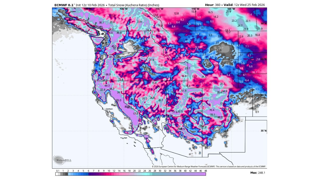
According to the projected accumulation map extending out 360 hours, several mountain regions could measure snow in feet rather than inches — with parts of the Sierra Nevada potentially exceeding 70 inches, and some localized peaks pushing even higher.
Sierra Nevada Positioned for Exceptional Totals
The most dramatic snowfall projections appear along the Sierra Nevada mountain range in California, particularly from near Lake Tahoe south toward Mammoth Mountain. Broad areas display totals in the 60–80 inch range, with isolated higher elevations exceeding that threshold.
The western slopes of the Sierra appear especially favored due to consistent Pacific moisture flow and orographic lift — where air is forced upward over terrain, enhancing snowfall. If the storm sequence verifies as shown, this would represent a significant boost to the California snowpack heading into late winter.
This kind of prolonged pattern suggests multiple waves of energy rather than a single storm, meaning snowfall may accumulate steadily over many days instead of all at once.
Cascades and Pacific Northwest Also in the Bullseye
Northward into Oregon and Washington, the Cascade Range shows widespread moderate to heavy totals. Mountain areas near Mount Hood, Mount Bachelor, and into Washington’s higher elevations could see substantial accumulation.
Even parts of British Columbia show enhanced snowfall along coastal and interior mountain zones. While lower elevations near major cities may see limited impacts, mountain passes could experience challenging travel conditions during peak periods.
Rockies From Idaho to Colorado Showing Strong Signal
Across the Northern Rockies, snowfall extends through Idaho and western Montana, with many high-elevation zones showing double-digit totals.
Further south, the Wasatch Range in Utah and the Colorado Rockies display significant snowfall pockets as well. Totals in favored terrain could exceed 20 to 40 inches in some areas depending on elevation.
Mountain ranges in Wyoming, northern Arizona, and northern New Mexico also show measurable snowfall, reinforcing that this is a broad Western event rather than a narrowly focused system.
Why This Pattern Is So Impressive
The extended forecast suggests a sustained Pacific storm track feeding moisture into the West. The repeated delivery of moisture combined with favorable cold air over higher elevations creates ideal conditions for cumulative snowfall growth.
The timeframe through 12z Wednesday, February 25 indicates that this is not a one-day event but a multi-system parade. When storms arrive back-to-back, snowpack deepens quickly, especially in regions like the Sierra where terrain enhances precipitation.
For California, this is especially meaningful. Strong snowpack development acts as a natural reservoir, slowly releasing water into rivers and reservoirs during spring and early summer melt season.
Travel and Infrastructure Impacts to Monitor
With projected totals in feet for some regions, mountain travel across:
- Interstate 80 near Donner Pass
- Highway 50 in California
- Interstate 90 across Washington
- Colorado mountain corridors along I-70
could face chain controls, closures, or hazardous winter driving conditions during active snowfall periods.
Ski resorts across California, Utah, Colorado, and the Pacific Northwest stand to benefit significantly, though intense snowfall bursts and strong winds may temporarily affect lift operations.
Lower elevations across the West are not projected to see the same extreme totals, with snowfall largely confined to mountainous terrain.
A Welcome Boost for Western Snowpack
While heavy snow can create short-term travel challenges, the broader picture is encouraging for water supply. Strong late-winter snowfall in the Sierra Nevada and across Western mountains helps build the snowpack necessary for sustained spring runoff.
If projections verify even partially, the Western U.S. could see one of its more substantial February snow cycles in recent seasons.
Forecast totals at this range can still shift, especially with the timing and track of individual waves. However, confidence is high that mountain regions across the West will remain active through late February.
For continued updates on major weather systems affecting travel, events, and music communities nationwide, stay tuned to ChicagoMusicGuide.com for the latest coverage.